Rükl 49
Contents
Rükl Zone 49 - LANGRENUS
Neighboring maps on the Rükl Nearside Map:
Table of Contents
[#Rükl Zone 49 - LANGRENUS Rükl Zone 49 - LANGRENUS]
[#Rükl Zone 49 - LANGRENUS-Photographic Map Photographic Map]
[#Rükl Zone 49 - LANGRENUS-Nearside Named Features Nearside Named Features]
[#Rükl Zone 49 - LANGRENUS-Farside Named Features Farside Named Features]
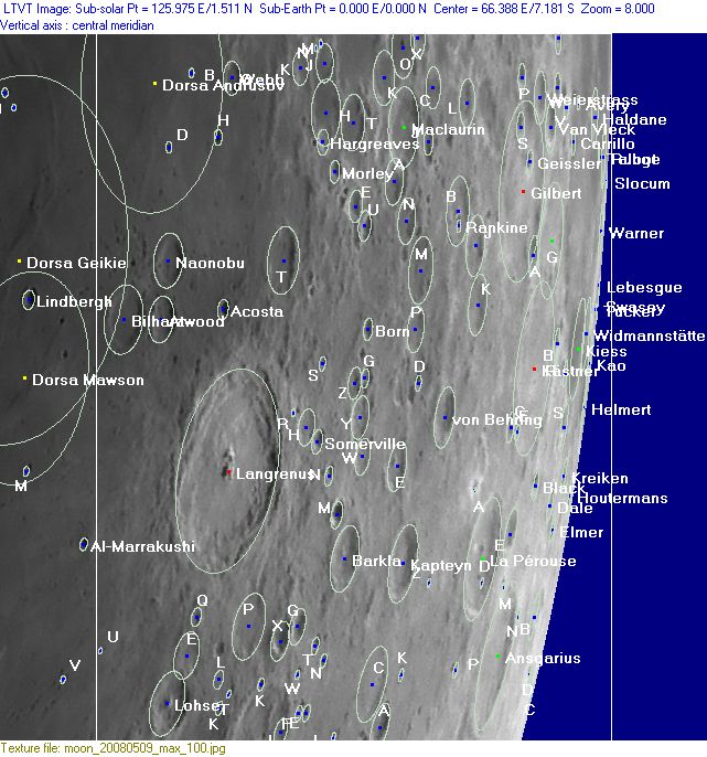
[#Rükl Zone 49 - LANGRENUS-Lettered Crater Locations Lettered Crater Locations]
[#Rükl Zone 49 - LANGRENUS-Lettered Crater Locations-Full zone with lettered craters Full zone with lettered craters]
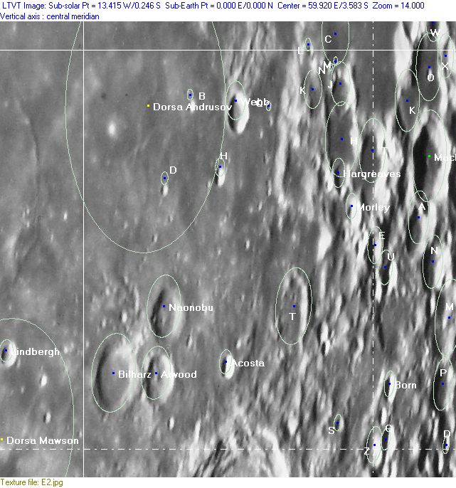
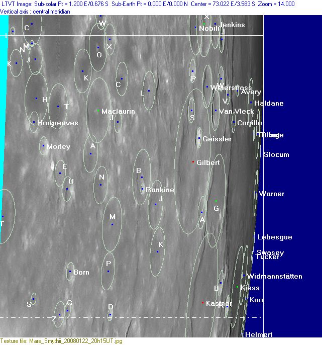
[#Rükl Zone 49 - LANGRENUS-Lettered Crater Locations-Lettered craters by quadrants Lettered craters by quadrants]
[#Rükl Zone 49 - LANGRENUS-Additional Information Additional Information]
[#Rükl Zone 49 - LANGRENUS-The equatorial zone near the eastern limb: a lunar nomenclaturist's nightmare The equatorial zone near the eastern limb: a lunar nomenclaturist's nightmare]
[#Rükl Zone 49 - LANGRENUS-Color anomalies in Langrenus Color anomalies in Langrenus]
| 49 |
||
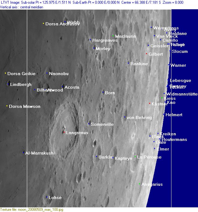
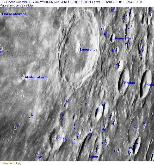
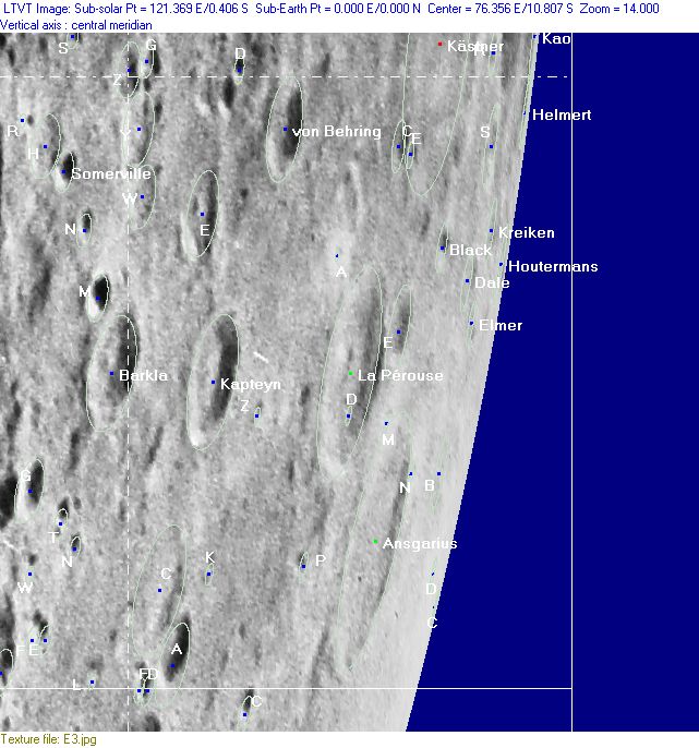
Photographic Map
(This map is based on an Earth-based photograph that has been computer-corrected to zero libration. The vertical white lines indicate the left and right boundaries of the Rükl rectangle)

  Background image source
Nearside Named Features
- Acosta
- Ansgarius
- Atwood (once called Aller by H.P.Wilkins) (W.R.Birt wanted to see the names of Baker, Livingstone, and Stanley at the trio of craters which are nowadays officially known as Atwood, Bilharz, and Naonobu) (Van Langren called these three craters S.Bedae) (J.Hewelcke called them Insula Minor).
- Avery
- Balmer-Kapteyn Basin (unofficial name) (see also Rukl Zone 60).
- Barkla
- Bilharz (one of the three craters which were once known as Van Langren's S.Bedae and J.Hewelcke's Insula Minor) (Bilharz was once called Vally by F.C.Lamech).
- Black
- Born
- Carrillo
- Cellini (a disallowed name for Kastner S, see Lunar Topographic Orthophotomap 81-B4).
- Chekov (a disallowed name for Kastner R, see Lunar Topographic Orthophotomap 81-B4).
- Dale
- Defoe (a disallowed name for Kastner B, see Lunar Topographic Orthophotomap 81-B4) (seems to have been called Watts by H.P.Wilkins).
- Dorsa Andrusov
- Dumas (a disallowed name for a crater east-northeast of Kastner, see Lunar Topographic Orthophotomap 81-B4).
- Elmer
- Geissler
- Gilbert
- Haldane
- Hargreaves
- Helmert
- Houtermans
- Johnson (a disallowed name for a crater west of Brunner, see Lunar Topographic Orthophotomap 81-C2).
- KAMP (Apollo 11's Command Module Pilot (Michael Collins) seems to have called a crater in or near Mare Spumans "KAMP", in honour of his family (Kate, Ann, Michael, and Pat). Source: John Moore, see discussion at LPOD 25-10-2009).
- Kao
- Kapteyn (J.Hewelcke's Montes Hippoci).
- Kästner
- Kiess (with Widmannstatten this pair was once called Wright Brothers by lunar scientists of NASA, see APOLLO 17 Preliminary Science Report, P. 28-12).
- Kreiken
- La Pérouse
- La Pérouse A (this is a most interesting high-albedo ray crater northwest of La Pérouse itself, because it looks like a bright star during local sunset circumstances).
- Langrenus (Van Langren's Langreni, J.Hewelcke's Insula Major) (note: orbiting Apollo astronauts reported rusty colored spots in this crater, see Additional Information below).
- Lebesgue
- Lohse
- Luna 16 (soft landed on September 20, 1970, west of Webb in Sinus Successus, near the upper left corner of Chart 49) (note: Antonin Rukl's small pocket moonatlas Moon, Mars, and Venus shows the landingsite of Luna 16 near the lower left corner of Chart 38).
- Maclaurin
- Mare Fecunditatis (Van Langren's Mare Langrenianum, J.Hewelcke's Mare Caspium) (the most eastern part of it, occupying the upper left section of Chart 49).
- Mare Smythii (at the upper right corner of Chart 49, see Chart 38 for wiki-link).
- Mare Spumans (the southern part of it, at the central section of Chart 49's upper margin, see Chart 38 for wiki-link).
- Montes Hippoci (J.Hewelcke's disallowed name for Kapteyn and Maclaurin F).
- Morley
- Naonobu (one of the three craters which were once known as Van Langren's S.Bedae and J.Hewelcke's Insula Minor).
- Novalis (a disallowed name for a crater south of Elmer, see Lunar Topographic Orthophotomap 81-C1).
- Paludes (J.Hewelcke's disallowed name for the east-southeastern limb region).
- Pope (a disallowed name for a crater west of Brunner, see Lunar Topographic Orthophotomap 81-C2).
- Rankine
- Runge
- S.Bedae (Van Langren's disallowed name for the three craters Atwood, Bilharz, and Naonobu) (J.Hewelcke called them Insula Minor).
- Sinus Successus (near the upper left corner of Chart 49, see Chart 38 for wiki-link).
- Slocum
- Somerville
- Swasey
- Talbot
- Terra Pacis (Van Langren's disallowed name for the whole of Chart 49) (sans Mare Fecunditatis at upper left).
- Terra Vigoris (Riccioli's discontinued name for the whole of Chart 49) (sans Mare Fecunditatis at upper left).
- Tucker
- Van Vleck
- von Behring
- Warner
- Watts (a disallowed name from H.P.Wilkins for Kastner B) (was also known as Defoe on LTO-map 81-B4).
- Webb
- Weierstrass
- Widmannstätten (see at Kiess for the disallowed name Wright Brothers).
- Zola (a disallowed name for a crater south of Houtermans, see Lunar Topographic Orthophotomap 81-C2).
Farside Named Features
(The following features are not formally included in the present Rükl rectangle, but they are adjacent to it and their centers are less than 10° beyond the mean limb -- so they may be seen here in whole or in part with a favorable libration)
Lettered Crater Locations
(click on the thumbnails to view full-sized images; use browser BACK button to return to this page)
Full zone with lettered craters
Lettered craters by quadrants
(the dashed white lines are the centerlines of the Rükl zones)
| North West |
North East |
| South West |
South East |
Additional Information
- Other online descriptions of features in this Rükl map section:
The equatorial zone near the eastern limb: a lunar nomenclaturist's nightmare
- This region (west and southwest of Mare Smythii) and the adjacent northern region at Map 38 was the most photographed area during the whole Apollo program. It is also the moon's area which is literally swimming in official nomenclature. A look at page 124 of Antonin Rükl's original Atlas Of The Moon shows the impressive list of names for this region. - DannyCaes DannyCaes Nov 4, 2008
Color anomalies in Langrenus
- According to NASA's book Apollo 14 Preliminary Science Report, there should be color anomalies in Langrenus. Page 275: “A distinct rusty color is evident in one of a group of smooth bulbous domes with single or multiple furrows at or near the crests” (on the eastern wall of Langrenus). See also: Colored Regions on the Moon's Surface (Part 1).
This page has been edited 1 times. The last modification was made by - tychocrater tychocrater on Jun 13, 2009 3:24 pm - mgx2
