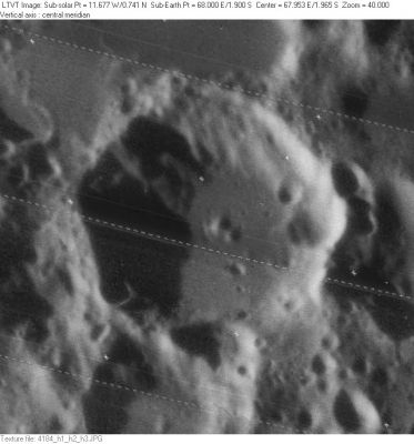
Maclaurin
Contents
Maclaurin
| Lat: 1.9°S, Long: 68.0°E, Diam: 50 km, Depth: 3.38 km, Rükl: 49 |
Images
LPOD Photo Gallery Lunar Orbiter Images Apollo Images
- AS15-88-11959 shows Apollo 15's CSM Endeavour over the southern part of Mare Spumans (upper right corner) and Maclaurin (just above the third cross rightward of the large central cross). Looking southeastward. See also LAC 80 in Ben Bussey's and Paul Spudis's Clementine Atlas of the Moon.
- AS16-122-19530 shows the approaching Ascent Stage of Apollo 16's LM Orion, with Maclaurin just leftward of it. The southern part of Mare Spumans is seen below the black silhouette (upper margin).
- Research orbital Apollo photography: Danny Caes
Maps
(LAC zone 80B2) LAC map Geologic map LTO map
Description
Description: Elger
(IAU Directions) MACLAURIN.--The principal member of a group of irregular ring-plains on the E. side of the Mare Fecunditatis, a little S. of the lunar equator. Schmidt shows no details within it, except a small crater on the W. side of the floor.
Description: Wikipedia
Additional Information
- Depth data from Kurt Fisher database
Pike, 1976: 3.38 km
Westfall, 2000: 3.38 km
Cherrington, 1969: 1.09 km - According to the shadows in LO-IV-184H, the height of the straight section of west wall varies from about 2900 m in the south to 3900 m in the north. The central peaks appear to be about 400 m tall. - JimMosher
- Maclaurin EA is a thermal anomaly crater, implying a youthful age - Moore et al, 1980
Nomenclature
Colin; Scottish mathematician (1698-1746). (Spelling changed from MacLaurin.)
LPOD Articles
Bibliography
