Imbrium, Mare
Contents
Imbrium Basin
(unofficial name; IAU feature name for central 1,123 km of mare: Mare Imbrium )
|
Lat: 32.8°N, Long: 15.6°W, Main ring diam: 1,160 km, Basin depth: 2.9 km, Rükl: 11 |


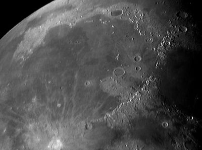
Left: Peter Lloyd (note the couple of pronounced ejecta-rays from Copernicus, running across the southern part of Mare Imbrium).
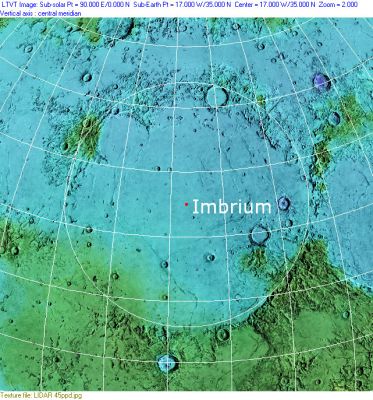
Right: Clementine, Clementine LIDAR Altimeter texture from PDS Map-a-Planet remapped to north-up aerial view by LTVT. The dot is the center position and the white circle the main ring position from Chuck Wood's Impact Basin Database. Grid spacing = 10 degrees.
Images
LPOD Photo Gallery Lunar Orbiter Images Apollo ImagesNew composite Clementine/various images
Maps
(LAC zone 24C3) LAC map Geologic map
Basin Classification
(description of terms and most numeric basin data from Wood, C.A. (2004) Impact Basin Database)
| Certainty of Existence |
USGS Age |
Wilhelms Age Group |
Ring Diameters |
Mare Thickness |
Mascon |
| Certain |
Imbrian |
12 |
550, 790, 1160, 1700, 2250, 3200 km |
5.24 km |
Yes, +88 mG gravity anomaly |
Description
The Imbrium Basin, an ancient impact basin that has been infilled by impact and volcanic materials since its formation, dominates the morphology of this region. Mountain ranges with peaks up to 5500 meters above the mean lunar radius (Montes Apenninus in the S-SE) define most of the circular morphology of the basin.

  Further north, stretching for around 200 km with peaks of 3,650 meters, Montes Caucasus delineate the border between mare Imbrium and Mare Serenitatis in the east (360,000 km2). Continuing in an anticlockwise direction, we meet another mountain chain: Montes Alpes. The progressive infilling of the basin and the nearby excavation of a large crater (Cassini) gave rise to the formation of promontories Deville and Agassiz. Vallis Alpes, a nearly rectilinear valley 130 km long and 10 km wide, dissects the mountain range and features a lava channel linking Imbrium Basin and Mare Frigoris in to the north. We find similar valleys at other large impact basins on the Moon and these are often interpreted as grabens produced by faulting at the time of formation of the raised rims. Subsequent lava flows infilled the depression, as demonstrated by a prominent rille occupying the centre of the valley.

  Further west, we encounter the semi-circular mountain chain Montes Jura, with peaks reaching 3800 meters. They outline a secondary circular structure that has ‘lost’ its southeastern rim: Sinus Iridum. This 260 km crater was excavated not long after the formation of the Imbrium basin. Subsequently, the newly formed circular depression, 600 meters lower than the average neighbouring mare topography, was infilled by numerous lava flows. Promontories Laplace and Heraclides terminate the semicircular mountain chain. Montes Gruithuisen Gamma and Delta today give away to a vast stretch of maria connecting the Imbrium Basin with Oceanus Procellarum. Dorsi Bucher and Arduino, together with Montes Delisle, Harbinger, and Vinogradov may represent the remnants of the missing crater rim section.

  The projected circular rim ‘re-emerges’ at 15 N 30 W in the form of the 280 km long chain of Montes Carpatus. This is characterised by peaks of around 2,400 meters, craters Tobias Mayer (35 km) and Gay-Lussac (24 km), and in the north, the promontory Cape Banat.

  Smaller mountain chains are also found within the basin, for instance the northern Montes Recti (2,020 m high), Teneriffe (1,450), and eastern Spitzbergen (1,450).

 Mons Pico and Mons Piton, both around 2,400 meter high, are two isolated mountain peaks that stand out in the northeast.
Major Craters
Along with Sinus Iridum, the region under study features many other well-known large craters. Mare Imbrium is dominated in the south by the bright rays of Copernicus (107 km, 10 N 20 W), which can be still detected nearly to the centre of the basin (~30 N). Eratosthenes (60 km) is located just south of the Montes Apenninus near Sinus Aestuum and it is characterised by an elevated crater rim (3,900 m). Archimedes and Plato are both flat-floored craters, infilled by mare materials, and of comparable age and dimensions (~100 km diameter and 2,000 m height). Aristillus and Autolycus are two major craters found in the west of the basin, the former characterised by a system of valleys radiating towards Mare Imbrium and Palus Nebularum. Other major craters within the mare are Cassini (29 km – 2,400 m), Timocharis (40 – 2,870), Lambert (29 – 2,400), Euler (28 –2,200), Delisle (26 – 2,420), Diophantus (21 – 2,590), Le Verrier (18 – 2,450).
Marginal Areas and Neighbouring Regions
Palus Nebularum and Palus Putredinis represent two marginal mare locations that have become ‘isolated’ following the major impacts Archimedes, Aristillus, and Autolycus.
Mare Imbrium borders in the north with Mare Frigoris (251,000 km2) and Sinus Roris, Mare Serenitatis in the East, Sinus Aestuum (25,000 km2) and Mare Insularum in the South, and in the west with Oceanus Procellarum (4,000,000 km2).
- bugiolacchi
Description: Wikipedia
Additional Information
- Depth data from Kurt Fisher database
Cherrington, 1969: -2.44 km - Mare area of 1,130,000 km^2 according to measurements by Jim Whitford-Stark.
- "Herringbone" ridges south of Heinrich (between Heinrich and Eratosthenes): APOLLO OVER THE MOON; A VIEW FROM ORBIT, Chapter 5: Craters (Part 3), Figure 124.
- Another "Herringbone" at 22°30' North/ 24°30' West (between Pytheas and Euler): Part 3, Figures 126 and 127.
Schroter's observation of a peculiar phenomenon at Mare Imbrium
Source: W.R.Corliss, Mysterious Universe; a handbook of astronomical anomalies, pages 220-221
  (Bispham, K.; British Astronomical Association, Journal, 78:381, 1968)

  A few days before reading the Lunar Section Report by Patrick Moore, printed in the February issue of the Journal, I had been reading and doing some abstracting from Schroter's Selenographische Fragmente, and came across the quotations which I append below in a translation. These are in connection with Moore's remarks on the rarity of flashes on the moon.
  "As I was observing the night side of the moon on the 15th October, 1789 in the morning with the marking Plato, together with the Mare Imbrium in view, but absolutely nothing of the illuminated lunar hemisphere in the field, there arose, soon after 5 o'clock, in, or rather in front of the dark lunar disk, and just, in fact, in the centre of the Mare Imbrium, as far as I was able to report, after my sudden astonishment, and almost right in the middle of the field of telescope, quite suddenly and quickly, a bright burst of light, which was composed of many single, separate small sparks which had just such a white light as the illuminated day side of the moon, and which all moved away together in a straight line northwards over the northern part of the Mare Imbrium and the other parts of the moon's surface bordering this to the north, but from there onwards through the remaining empty field of the telescope.
  "When this light shower had travelled half its distance, a further, similar burst of light arose to the south of it over just the same place or perhaps somewhat more to the east of where the first originated: the second was exactly the same in appearance as the first, composed of like, small, white sparks of light which flashed away in the same direction and in an exact parallel direction towards the north, as far as the edge of the telescopic field.
  "Startling as this impression was also, which this distant light phenomenon made on me, nevertheless, I quickly recovered my wits, re-imagined this phenomenon repeatedly, and vividly after it had quite disappeared and estimated, using a pocket watch, the time it took each shower of light to travel from the position of origin to the edge of the telescope field as about 2 seconds, and thus the complete duration of this phenomenon as 4 seconds, in which time it was all over without leaving the faintest trace behind".
  Of the multitude of changes reported in Schroter's book, this is surely one of the strangest.
Nomenclature
The IAU feature name means "Sea of Showers".
- Named Regio Magna Orientalis (Large Eastern Region) on pre-telescopic sketch map by William Gilbert in ~1600 AD [Whitaker: Mapping and Naming the Moon, p 15]
- The impact basin is named after the mare.
- Called Mare Mediterraneum by Johann Hewelcke (see his moonmap of 1647, "Figure Q", page 53 of E.A.Whitaker's book).
- The Sixteen-West ray (a nickname by Danny Caes for the easternmost one of the two pronounced ejecta-rays from Copernicus) (running at approximately 16 degrees West across the southern part of Mare Imbrium).
- The Nineteen-West ray (a nickname by Danny Caes for the westernmost one of the two pronounced ejecta-rays from Copernicus) (running at approximately 19 degrees West across the southern part of Mare Imbrium).
LPOD Articles
- The Woefull State of Lunar Image Maps
- More Spectacular Flows in Imbrium
- Northern Arc
- Raisin Pits
- A Penetrating View of Imbrium
- Crazy Quilt Imbrium
- X-Raying Imbrium
- Brown Flows
Lunar 100
- L98: Mare lava-flow boundaries.
Bibliography
- Schultz, P. H. and Crawford, D. A. (2016). Origin and implications of non-radial Imbrium Sculpture on the Moon – Nature, Volume: 535, Pages: 391–394. DOI: doi:10.1038/nature18278. Date published: (21 July 2016).
- Nakamura, R. et al (2012). Compositional evidence for an impact origin of the Moon’s Procellarum basin – Nature Geoscience, Vol 5, No 10, DOI:10.1038/ngeo1614. Published 28 Oct, 2012.
- Schultz, P. (1995) Making the Man in the Moon: Making the Imbrium Basin. LPSC, 26th, p 1251.
- Wood, C.A. Feb. 2005. In and around Imbrium. S&T Feb 2005 v109 p72
- Wood, C.A. 4/2007. Mystery Maria. S&T 113(4):63-64