Difference between revisions of "Malapert"
| (2 intermediate revisions by the same user not shown) | |||
| Line 5: | Line 5: | ||
Lat: 84.9°S, Long: 12.9°E, Diam: 69 km, Depth: km, [[R%C3%BCkl%2073|Rükl 73]]<br /> | Lat: 84.9°S, Long: 12.9°E, Diam: 69 km, Depth: km, [[R%C3%BCkl%2073|Rükl 73]]<br /> | ||
|} | |} | ||
| − | [http://www.lpod.org/coppermine/albums/userpics/Malapert_LO-IV-154H_LTVT.JPG [[Image: | + | [http://www.lpod.org/coppermine/albums/userpics/Malapert_LO-IV-154H_LTVT.JPG [[Image:Normal_Malapert_LO-IV-154H_LTVT.JPG|external image normal_Malapert_LO-IV-154H_LTVT.JPG]]][http://www.lpod.org/coppermine/albums/userpics/LTVT_Diviner_Malapert.jpg [[Image:Normal_LTVT_Diviner_Malapert.jpg|external image normal_LTVT_Diviner_Malapert.jpg]]][[Image:S-Pole-sband_100m1-Malapert_crop.jpg|S-Pole-sband_100m1-Malapert_crop.jpg]]<br /> '''Left''': Overhead view by ''[http://lpod.org/coppermine/displayimage.php?pos=-1997 LO-IV-154H]'' The brightly lit ridges above and below the center of this image are the north and southwest rims of '''Malapert'''. Because the Sun strays just 1½ degrees north and south of the Moon's equator, craters at high latitudes are always seen at low sun angles, and their floors are in perpetual darkness.<br /> '''Middle''': Infrared temperature map from the ''[http://lpod.org/coppermine/displayimage.php?pos=-4385 Diviner]'' instrument on LRO, with the principal IAU names. The area between [[Haworth|Haworth]] and [[Nobile|Nobile]] does not appear to be regarded as part of '''Malapert'''. Topographic maps of the [[south%20pole|south pole]] are helpful for understanding the relative depths of these features.<br /> '''Right''': Earth-based radar view by ''[http://www2.lpod.org/wiki/November_7,_2006 Campbell et al.]'' When the librations are favorable, the Moon's south pole can tip towards Earth by more than 7 degrees. Hence, as shown here, radar waves transmitted from Earth can illuminate more of '''Malapert's''' floor than can sunlight (note: in the LPOD image from which this has been cropped, the Earth-based radar data was re-mapped to a north-up aerial view).<br /> <div id="toc"> |
| − | + | ||
| − | |||
==Images== | ==Images== | ||
[http://www.lpod.org/coppermine/thumbnails.php?album=search&type=full&search=Malapert LPOD Photo Gallery] [http://www.lpi.usra.edu/resources/lunar_orbiter/bin/srch_nam.shtml?Malapert%7C0 Lunar Orbiter Images]<br /> - Although it is not mentioned in the LPI's search-list of orbital Apollo photographs, the crater called '''Malapert''' WAS photographed during the mission of Apollo 15. It was captured near the central part of the upper margin of frame [http://www.lpi.usra.edu/resources/apollo/frame/?AS15-95-12988 AS15-95-12988] (near the terminator). '''Malapert''' could be the most southern crater which was once photographed during the Apollo project. A High-Resolution scan of AS15-95-12988 is needed!<br /> - Research: Danny Caes.<br /> <br /> | [http://www.lpod.org/coppermine/thumbnails.php?album=search&type=full&search=Malapert LPOD Photo Gallery] [http://www.lpi.usra.edu/resources/lunar_orbiter/bin/srch_nam.shtml?Malapert%7C0 Lunar Orbiter Images]<br /> - Although it is not mentioned in the LPI's search-list of orbital Apollo photographs, the crater called '''Malapert''' WAS photographed during the mission of Apollo 15. It was captured near the central part of the upper margin of frame [http://www.lpi.usra.edu/resources/apollo/frame/?AS15-95-12988 AS15-95-12988] (near the terminator). '''Malapert''' could be the most southern crater which was once photographed during the Apollo project. A High-Resolution scan of AS15-95-12988 is needed!<br /> - Research: Danny Caes.<br /> <br /> | ||
| Line 15: | Line 14: | ||
<br /> | <br /> | ||
==Description: Elger== | ==Description: Elger== | ||
| − | ''([[IAU% | + | ''([[IAU%20directions|IAU Directions]])'' MALAPERT.--A ring-plain situated far too near the limb for useful observation. Between it and [[Newton|Newton]] is a number of abnormally shaped enclosures.<br /> <br /> |
==Description: Wikipedia== | ==Description: Wikipedia== | ||
[http://en.wikipedia.org/wiki/Malapert_(crater) Malapert]<br /> <br /> | [http://en.wikipedia.org/wiki/Malapert_(crater) Malapert]<br /> <br /> | ||
==Additional Information== | ==Additional Information== | ||
| − | * The lunar peak on '''Malapert''''s southwest rim, assigned the name '''Malapert Alpha''' in [[Whitaker%2C%201954|Whitaker, 1954]], has been widely touted (usually under the name "Malapert Mountain" or "Malapert Peak") as an ideal base for future lunar observers. Some of the proponents have incorrectly stated that it is bathed in continuous sunlight. <span class="membersnap">- | + | * The lunar peak on '''Malapert''''s southwest rim, assigned the name '''Malapert Alpha''' in [[Whitaker%2C%201954|Whitaker, 1954]], has been widely touted (usually under the name "Malapert Mountain" or "Malapert Peak") as an ideal base for future lunar observers. Some of the proponents have incorrectly stated that it is bathed in continuous sunlight. <span class="membersnap">- JimMosher</span> |
<br /> | <br /> | ||
==Nomenclature== | ==Nomenclature== | ||
| Line 27: | Line 26: | ||
* [[Neison%2C%201876|Neison, 1876]], which greatly influenced the original [[IAU%20nomenclature|IAU nomenclature]], seems to follow [[Beer%20and%20M%C3%A4dler|Beer and Mädler]] in placing '''Malapert''' to the west of the Moon's prime meridian, directly under the peak Neison designated [[Montes%20Leibnitz#Neison|Leibnitz Alpha]] -- which can be identified with [[Whitaker%2C%201954|Whitaker, 1954]]'s '''M5'''/'''M4'''. This does not agree with the position of the modern '''Malapert'''. | * [[Neison%2C%201876|Neison, 1876]], which greatly influenced the original [[IAU%20nomenclature|IAU nomenclature]], seems to follow [[Beer%20and%20M%C3%A4dler|Beer and Mädler]] in placing '''Malapert''' to the west of the Moon's prime meridian, directly under the peak Neison designated [[Montes%20Leibnitz#Neison|Leibnitz Alpha]] -- which can be identified with [[Whitaker%2C%201954|Whitaker, 1954]]'s '''M5'''/'''M4'''. This does not agree with the position of the modern '''Malapert'''. | ||
* The name '''Malapert Alpha''' in the original [[IAU%20nomenclature|IAU nomenclature]] of [[Blagg%20and%20M%C3%BCller|Blagg and Müller]] (1935) was discontinued, along with most other Greek-lettered peaks, in [[IAU%20Transactions%20XVB|1973]]. Since [[Neison%2C%201876|Neison, 1876]] draws and describes it as being well to the west of '''Malapert''' (towards [[Cabeus|Cabeus]]), it seems unlikely to have been the same as [[Whitaker%2C%201954|Whitaker, 1954]]'s '''Malapert Alpha'''. | * The name '''Malapert Alpha''' in the original [[IAU%20nomenclature|IAU nomenclature]] of [[Blagg%20and%20M%C3%BCller|Blagg and Müller]] (1935) was discontinued, along with most other Greek-lettered peaks, in [[IAU%20Transactions%20XVB|1973]]. Since [[Neison%2C%201876|Neison, 1876]] draws and describes it as being well to the west of '''Malapert''' (towards [[Cabeus|Cabeus]]), it seems unlikely to have been the same as [[Whitaker%2C%201954|Whitaker, 1954]]'s '''Malapert Alpha'''. | ||
| − | * [[Whitaker|Whitaker]] (p.25) dismisses Malapert's [http://www.coelum.com/calanca/luna_malapert.htm map] as having "almost no merit", though it seems not much different from the engravings of Galileo, which Whitaker much admires. Malapert's engraving has the advantage of being dated, so that it can be compared to what would actually have been observed. It can be easily verified that the phase depicted agrees very well with what might have been seen in the pre-dawn hours of November 29, 1619, the stated date. The detailed features are less clear, but it appears to show [[Plato|Plato]], as expected, on the terminator to the north, with [[Eratosthenes|Eratosthenes]] and [[Copernicus|Copernicus]] below it. To the left of those Malapert appears to be indicating (somewhat out of place) the bright areas around [[Kepler|Kepler]] and [[Aristarchus|Aristarchus]]. In the south, [[Clavius|Clavius]] would have been on the terminator, and two craters, possibly [[Bullialdus|Bullialdus]] and [[Campanus|Campanus]], seem to have caught Malapert's eye and are shown to the left of his representation of the pockmarked lunar southern highlands. <span class="membersnap">- | + | * [[Whitaker|Whitaker]] (p.25) dismisses Malapert's [http://www.coelum.com/calanca/luna_malapert.htm map] as having "almost no merit", though it seems not much different from the engravings of Galileo, which Whitaker much admires. Malapert's engraving has the advantage of being dated, so that it can be compared to what would actually have been observed. It can be easily verified that the phase depicted agrees very well with what might have been seen in the pre-dawn hours of November 29, 1619, the stated date. The detailed features are less clear, but it appears to show [[Plato|Plato]], as expected, on the terminator to the north, with [[Eratosthenes|Eratosthenes]] and [[Copernicus|Copernicus]] below it. To the left of those Malapert appears to be indicating (somewhat out of place) the bright areas around [[Kepler|Kepler]] and [[Aristarchus|Aristarchus]]. In the south, [[Clavius|Clavius]] would have been on the terminator, and two craters, possibly [[Bullialdus|Bullialdus]] and [[Campanus|Campanus]], seem to have caught Malapert's eye and are shown to the left of his representation of the pockmarked lunar southern highlands. <span class="membersnap">- JimMosher</span> |
<br /> | <br /> | ||
==LPOD Articles== | ==LPOD Articles== | ||
| Line 48: | Line 47: | ||
<br /> | <br /> | ||
---- | ---- | ||
| − | + | </div> | |
Latest revision as of 20:24, 16 April 2018
Contents
Malapert
|
Lat: 84.9°S, Long: 12.9°E, Diam: 69 km, Depth: km, Rükl 73 |


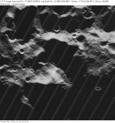
Left: Overhead view by LO-IV-154H The brightly lit ridges above and below the center of this image are the north and southwest rims of Malapert. Because the Sun strays just 1½ degrees north and south of the Moon's equator, craters at high latitudes are always seen at low sun angles, and their floors are in perpetual darkness.
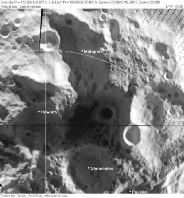
Middle: Infrared temperature map from the Diviner instrument on LRO, with the principal IAU names. The area between Haworth and Nobile does not appear to be regarded as part of Malapert. Topographic maps of the south pole are helpful for understanding the relative depths of these features.
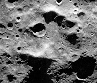
Right: Earth-based radar view by Campbell et al. When the librations are favorable, the Moon's south pole can tip towards Earth by more than 7 degrees. Hence, as shown here, radar waves transmitted from Earth can illuminate more of Malapert's floor than can sunlight (note: in the LPOD image from which this has been cropped, the Earth-based radar data was re-mapped to a north-up aerial view).
Images
LPOD Photo Gallery Lunar Orbiter Images
- Although it is not mentioned in the LPI's search-list of orbital Apollo photographs, the crater called Malapert WAS photographed during the mission of Apollo 15. It was captured near the central part of the upper margin of frame AS15-95-12988 (near the terminator). Malapert could be the most southern crater which was once photographed during the Apollo project. A High-Resolution scan of AS15-95-12988 is needed!
- Research: Danny Caes.
Maps
(LAC zone 144A4) USGS Digital Atlas PDF
Description
Description: Elger
(IAU Directions) MALAPERT.--A ring-plain situated far too near the limb for useful observation. Between it and Newton is a number of abnormally shaped enclosures.
Description: Wikipedia
Additional Information
- The lunar peak on Malapert's southwest rim, assigned the name Malapert Alpha in Whitaker, 1954, has been widely touted (usually under the name "Malapert Mountain" or "Malapert Peak") as an ideal base for future lunar observers. Some of the proponents have incorrectly stated that it is bathed in continuous sunlight. - JimMosher
Nomenclature
- Named for Charles Malapert (1581-1630), a Belgian astronomer, mathematician, and philosopher. Malapert was known as a staunch opponent of the Copernicans, and used his own astronomical observations to attack them. He published one of the earliest images of the Last Quarter Moon, following Galileo.
- Use of this name on the Moon was introduced by Riccioli although the crater he intended to use the name for is highly uncertain. Whitaker believes it may have been the modern Simpelius B, which is probably as good a guess as any.
- Neison, 1876, which greatly influenced the original IAU nomenclature, seems to follow Beer and Mädler in placing Malapert to the west of the Moon's prime meridian, directly under the peak Neison designated Leibnitz Alpha -- which can be identified with Whitaker, 1954's M5/M4. This does not agree with the position of the modern Malapert.
- The name Malapert Alpha in the original IAU nomenclature of Blagg and Müller (1935) was discontinued, along with most other Greek-lettered peaks, in 1973. Since Neison, 1876 draws and describes it as being well to the west of Malapert (towards Cabeus), it seems unlikely to have been the same as Whitaker, 1954's Malapert Alpha.
- Whitaker (p.25) dismisses Malapert's map as having "almost no merit", though it seems not much different from the engravings of Galileo, which Whitaker much admires. Malapert's engraving has the advantage of being dated, so that it can be compared to what would actually have been observed. It can be easily verified that the phase depicted agrees very well with what might have been seen in the pre-dawn hours of November 29, 1619, the stated date. The detailed features are less clear, but it appears to show Plato, as expected, on the terminator to the north, with Eratosthenes and Copernicus below it. To the left of those Malapert appears to be indicating (somewhat out of place) the bright areas around Kepler and Aristarchus. In the south, Clavius would have been on the terminator, and two craters, possibly Bullialdus and Campanus, seem to have caught Malapert's eye and are shown to the left of his representation of the pockmarked lunar southern highlands. - JimMosher
LPOD Articles
- Polar Classic (Ewen Whitaker's map of South Pole)
- 20 m Resolution! (source of above radar image)
- A View of our Future (Malapert Alpha on horizon)
- Pole 2.0 (Malapert and surroundings, radar image)
LROC Articles
Bibliography
- Cooper, B. L. 2006. Craters and Channels on Malapert Mountain in the Lunar South Pole Region (PDF). Space Resources Roundtable VIII (online conference proceedings).
- Hill, Harold. A Portfolio of Lunar Drawings, pages 188, 189 (the south polar regions).
- Quignon, Georges. 1930. Charles Malapert, astronome montois (1581-1630). Ciel et Terre, Volume 46. Bulletin of the Société Belge d'Astronomie, Brussels, p. 4.
- Sharpe, Burton L.; Schrunk, David G. 2003. Malapert mountain: Gateway to the moon. Advances in Space Research, Volume 31, Issue 11, p. 2467-2472.