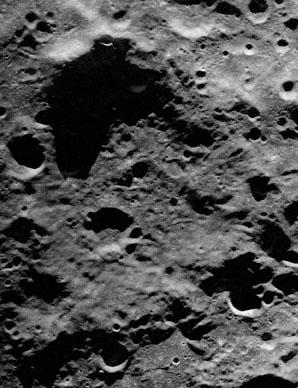
Cabeus
Contents
[hide]Cabeus
|
Lat: 85.28°S, Long: 41.81°W, Diam: 100.58 km, Depth: 5.71 km, Rükl: 73 |
Earth-based radar view by Campbell et al.: Cabeus is the large, somewhat irregular depression filling most of the frame. When the librations are favorable, the Moon's north pole can tip towards Earth by more than 7°. Hence radar waves transmitted from Earth can illuminate more of Cabeus' floor than can sunlight, which never shines from more than 1½° north of the Moon's equator. Note: in the LPOD image from which this has been cropped, the Earth-based radar data was re-mapped to a north-up aerial view, that is, the Earthward direction (from which the radar waves emanate) is to the top. The circular crater to the left of center, near the bottom of this view, has been named Ibn Bajja.
Images
LPOD Photo Gallery Lunar Orbiter Images Apollo Images
- Apollo 15's B-and-W Hasselblad frame AS15-95-12988 could be the only Apollo photograph on which the lunar south pole's immediate environs are seen. The crater Malapert is visible near the central part of the frame's upper margin. The south pole itself must be "touching" the upper margin (or perhaps a little bit beyond the margin).
- A High-Resolution scan of this frame (of AS15-95-12988) is needed! On the Hi-Res scan of it, we should get the answer to the question if Cabeus is also visible in it.
- Research Apollo 15 photograph: Danny Caes.
Maps
(LAC zone 144B3) USGS Digital Atlas Shaded Relief USGS Digital Atlas Lunar Orbiter
Description
Elger
(IAU Directions) CABEUS.--Another object out of the range of satisfactory scrutiny. Madler considered that it is as deep as Newton. According to Neison, a central peak and two craters can be seen within under favourable conditions. Schmidt draws a long row of great depressions on the N. side of it.
Wikipedia
Additional Information
- IAU page: Cabeus
- Depth data from Kurt Fisher database
- Westfall, 2000: 5.71 km
- NASA's LCROSS mission impacted in Cabeus on October 9, 2009.
Nomenclature
- Named for Niccolò Cabeo (February 26, 1586 – June 30, 1650), an Italian Jesuit philosopher. He is noted for his contributions to physics experiments and observations. Cabeo's second publication was a commentary on Aristotle's Meteorology. In this work, he carefully examined a number of ideas proposed by Galileo Galilei, including the motion of the earth and the law of falling bodies. Cabeo was opposed to Galileo's theories. Cabeo also discussed the theory of water flow proposed by Galileo's student, Benedetto Castelli.
- The name Cabeus was introduced by Riccioli. Whitaker (p. 211) believes the crater labeled by Riccioli is the modern Newton, but since only a single crater is drawn in an area occupied by many, it is difficult to say. - Jim Mosher
- In her Collated List Mary Blagg reported the name Cabaeus in use for the present feature (Catalog Number 3319) by Beer and Mädler and by Neison, 1876. She also found the name used by Julius Schmidt, but was uncertain what feature he intended to use the name for, since Schmidt's crater appeared to be farther to the east.
- According to a report by Arthur in IAU Transactions XIIB, Franz used the name Cabeus for the crater currently known as Drygalski.
- The name Cabaeus (for the present feature) was part of the original IAU nomenclature of Named Lunar Formations.
- The spelling was "corrected" to Cabeus in Table III of Kuiper's Photographic Atlas, where Cabaeus is said to be an "error by Blagg."
- John Westfall proposed calling Cabeus B, at 82.4° south/ 53.0° west, Bonestell (see: the south pole map on page 67 of the article Exploring the Moon's South Pole, by Alan M. MacRobert). Chesley Bonestell was one of the most important pioneers of Space Art, and was also one of the contributors to the legendary illustrated spaceflight articles by Wernher von Braun and Willy Ley in Collier's magazine. Westfall's suggestion was not adopted by the IAU, however Bonestell is honored by an IAU-named crater on Mars. - DannyCaes Apr 12, 2008
LPOD Articles
- A Wetter Hole? (LCROSS target selection)
- On Top of the World
- Polar Classic (Ewen Whitaker's map of South Pole)
- 20 m Resolution! (source of above radar image)
- A View of our Future (Cabeus in upper left)
Bibliography
- Elphic, R. C. et al (2011). The Average Water Concentration Within Cabeus Crater: Inferences from LRO/Diviner, LCROSS and Lunar Prospector – 42nd LPSC Conference (Mar), 2011.
- Farrell, W. M. et al (2011). Could Lunar Polar Ice be a ‘Fountain’ Source for the Dayside Water Veneer? – 42nd LPSC Conference (Mar), 2011.
- Hurley, D. M. et al (2011). Comparing LAMP Data to Models of the LCROSS Vapor Plume – 42nd LPSC Conference (Mar), 2011.
- Mitorfanov, I. G. et al (2011). Neutron Suppression Regions at Lunar Poles, as Local Areas of Water-Rich Permafrost – 42nd LPSC Conference (Mar), 2011.
- Moriarty, D. P. III et al (2011). Finsen and Alder: A Compositional Study of Lunar Central Peak Craters in the South Pole-Aitken Basin – 42nd LPSC Conference (Mar), 2011.
- Hill, Harold. 1991. A Portfolio of Lunar Drawings, pages 188, 189 (the south polar regions).
- Alan M. MacRobert. "Exploring the Moon's South Pole", Sky and Telescope, October 1993, pages 66-67.
Named Features -- Prev: Cabannes -- Next: Cai Lun
