Campanus
Contents
[hide]- 1 Campanus
- 1.1 Images
- 1.2 Maps
- 1.3 Description
- 1.4 Description: Elger
- 1.5 Description: Wikipedia
- 1.6 Additional Information
- 1.7 Field of Irregular Mare Patches (IMPs) to the east-northeast of the bowl-shaped crater Campanus A
- 1.8 Nomenclature
- 1.9 The mysterious name Golubiz Cluster
- 1.10 LPOD Articles
- 1.11 Bibliography
Campanus
|
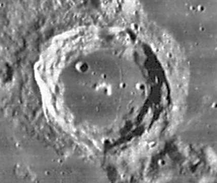
Lat: 28.0°S, Long: 27.8°W, Diam: 48 km, Depth: 2 km, Rükl: 53, Lower Imbrian |

LO-IV-131-h3
Note the rille on the eastern part of the floor of Campanus.
Images
LPOD Photo Gallery Lunar Orbiter Images Apollo Images
Maps
(LAC zone 94D4) LAC map Geologic map
Description
Description: Elger
(IAU Directions) CAMPANUS.--A ring-plain, 30 miles in diameter, on the rocky barrier, extending in nearly a straight line from Hippalus to Cichus. Its terraced walls, which rise on the W. more than 6,000 feet above the floor, are broken on the S. by a narrow valley, and on the W. by a small crater. A small central mountain is apparently the only object on a very dark interior.
Description: Wikipedia
Additional Information
- Depth data from Kurt Fisher database
- Pike, 1976: 2 km
- Westfall, 2000: 2 km
- Viscardy, 1985: 2.08 km
- Cherrington, 1969: 2.04 km
- Central peak composition: GNTA1, GNTA2 & AN (Tompkins & Pieters, 1999)
- Satellite crater Campanus A is on the ALPO list of bright ray craters and also on the ALPO list of banded craters
Field of Irregular Mare Patches (IMPs) to the east-northeast of the bowl-shaped crater Campanus A
- The exact coordinates of the main IMP in this field: LAT -25.70 / LON -27.66
- Catalogued as Number 5 (Nubium) in the list of known IMP fields.
Nomenclature
- Johannes Campanus of Navara (1220-1296) was an Italian astrologer, astronomer, and mathematician who devised a house system for the horoscope which bears his name. This house system divides the prime vertical into equal 30° arcs, or houses.
- Campanus Zeta (hill-complex north of Campanus, east of Campanus A) (see Chart 80 in the Times Atlas of the Moon).
- Rima Campanus (an unofficial name for the rille on the eastern part of the floor of Campanus).
- Chart 91 in the Times Atlas of the Moon and the lower left corner of LAC 94 show the shallow rille Rima Campanus I, south of Campanus, running toward the triplet of hillocks Marth Alpha, Beta, and Gamma. This rille is not named on charts E6 and E7 in the System of Lunar Craters. No trace of it on the LPI's red-labeled scan of Lunar Orbiter IV frame LOIV-131-h3.
The mysterious name Golubiz Cluster
- The system of hillocks east-northeast of Campanus (between Campanus and Kies) is unofficially known as the Golubiz Cluster. This name was printed on the greenish Rand McNally moonmap. It is not known if the dome Kies pi is also included in the Golubiz cluster. The exact origin of the name Golubiz Cluster is still unknown (who was Golubiz?). For a list of other mysterious names on this moonmap, see Rand McNally. - DannyCaes Aug 23, 2008
LPOD Articles
Bibliography
A Portfolio of Lunar Drawings (Harold Hill), pages 112, 113.