Difference between revisions of "Rükl 51"
(Created page with "<div id="content_view" class="wiki" style="display: block"> =Rükl Zone 51 - MERSENIUS= <br /> Neighboring maps on the [http://the-moon.us/wiki/R%C3%BCkl%20Index%20Map Rük...") |
|||
| (One intermediate revision by the same user not shown) | |||
| Line 2: | Line 2: | ||
=Rükl Zone 51 - MERSENIUS= | =Rükl Zone 51 - MERSENIUS= | ||
<br /> Neighboring maps on the [http://the-moon.us/wiki/R%C3%BCkl%20Index%20Map Rükl Nearside Map]:<br /> <div id="toc"> | <br /> Neighboring maps on the [http://the-moon.us/wiki/R%C3%BCkl%20Index%20Map Rükl Nearside Map]:<br /> <div id="toc"> | ||
| − | + | ||
| − | |||
{| class="wiki_table" | {| class="wiki_table" | ||
| | | | ||
| Line 70: | Line 69: | ||
(click on the thumbnails to view full-sized images; use browser BACK button to return to this page)<br /> <br /> | (click on the thumbnails to view full-sized images; use browser BACK button to return to this page)<br /> <br /> | ||
===Full zone with [[Satellite%20feature|lettered craters]]=== | ===Full zone with [[Satellite%20feature|lettered craters]]=== | ||
| − | [http://the-moon.us/wiki/file/detail/Rukl_51_satellites.jpg [[Image:Rukl_51_satellites.jpg|external image Rukl_51_satellites.jpg | + | [http://the-moon.us/wiki/file/detail/Rukl_51_satellites.jpg [[Image:Rukl_51_satellites.jpg|external image Rukl_51_satellites.jpg|64x64px]]]<br /> <br /> |
===Lettered craters by quadrants=== | ===Lettered craters by quadrants=== | ||
(the dashed white lines are the centerlines of the Rükl zones)<br /> | (the dashed white lines are the centerlines of the Rükl zones)<br /> | ||
| Line 78: | Line 77: | ||
|- | |- | ||
| | | | ||
| − | [http://the-moon.us/wiki/file/detail/Rukl_51_satellites_NW.jpg [[Image:Rukl_51_satellites_NW.jpg|external image Rukl_51_satellites_NW.jpg | + | [http://the-moon.us/wiki/file/detail/Rukl_51_satellites_NW.jpg [[Image:Rukl_51_satellites_NW.jpg|external image Rukl_51_satellites_NW.jpg|64x64px]]]<br /> |
| | | | ||
| − | [http://the-moon.us/wiki/file/detail/Rukl_51_satellites_NE.jpg [[Image:Rukl_51_satellites_NE.jpg|external image Rukl_51_satellites_NE.jpg | + | [http://the-moon.us/wiki/file/detail/Rukl_51_satellites_NE.jpg [[Image:Rukl_51_satellites_NE.jpg|external image Rukl_51_satellites_NE.jpg|64x64px]]]<br /> |
|- | |- | ||
| | | | ||
| − | [http://the-moon.us/wiki/file/detail/Rukl_51_satellites_SW.jpg [[Image:Rukl_51_satellites_SW.jpg|external image Rukl_51_satellites_SW.jpg | + | [http://the-moon.us/wiki/file/detail/Rukl_51_satellites_SW.jpg [[Image:Rukl_51_satellites_SW.jpg|external image Rukl_51_satellites_SW.jpg|64x64px]]]<br /> |
| | | | ||
| − | [http://the-moon.us/wiki/file/detail/Rukl_51_satellites_SE.jpg [[Image:Rukl_51_satellites_SE.jpg|external image Rukl_51_satellites_SE.jpg | + | [http://the-moon.us/wiki/file/detail/Rukl_51_satellites_SE.jpg [[Image:Rukl_51_satellites_SE.jpg|external image Rukl_51_satellites_SE.jpg|64x64px]]]<br /> |
|- | |- | ||
| South West<br /> | | South West<br /> | ||
| Line 98: | Line 97: | ||
<br /> | <br /> | ||
---- | ---- | ||
| − | + | </div> | |
Latest revision as of 17:02, 22 April 2018
Contents
Rükl Zone 51 - MERSENIUS
Neighboring maps on the Rükl Nearside Map:
| 51 |
||
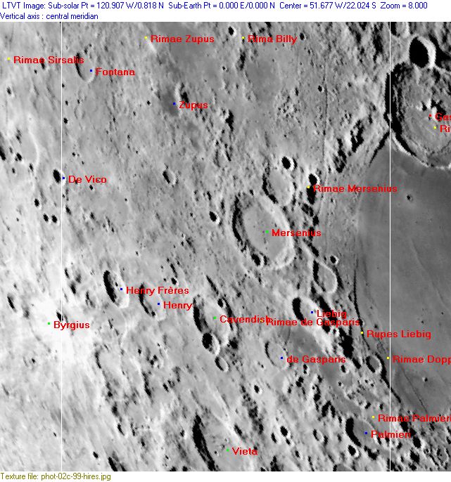
Photographic Map
(This map is based on an Earth-based photograph that has been computer-corrected to zero libration. The vertical white lines indicate the left and right boundaries of the Rükl rectangle)

  Background image source
Named Features
- Aegyptus (regio) (J.Hewelcke's disallowed name for the southwestern highlands).
- Byrgius A (once called La Paz by H.P.Wilkins) (Byrgius A is the bowl-shaped crater with high-albedo ejectablanket around it, at the left margin of Chart 51) (this was Van Langren's Malvezzi, J.Hewelcke's Mons Acabe).
- Cavendish (J.Hewelcke's Mons Ajax).
- de Gasparis
- De Vico
- Doppelmayer Pyroclastics (an informal name, incorporated on Chart FM3, page 82 in the 21st Century Atlas of the Moon (C.A. Wood/ M. Collins). This is the low-albedo region at the southwestern part of Mare Humorum).
- Eye (a nickname from D.Caes for Liebig J at the northern part of Rimae Doppelmayer) (Liebig J shows a rare bright "iris" at its inner slopes).
- Fluvius Nilus (J.Hewelcke's disallowed name for the dark streaks at Billy-Mersenius).
- Fontana
- Giovanelli (Van Langren's disallowed name for Mersenius Zeta).
- Guldini (Van Langren's disallowed name for Palmieri Alpha).
- Henry
- Henry Frères
- Jiyah (a disallowed name from H.P.Wilkins for Mersenius D).
- Lacus de Gasparis-Liebig-Palmieri (an unofficial name from D.Caes for the low-albedo region near the southwestern part of Mare Humorum's rim) (seems to have been called Paludes Arabiae by J.Hewelcke).
- Landerer (a disallowed name from H.P.Wilkins for Mersenius B).
- Liebig
- Magini (Van Langren's disallowed name for Liebig Gamma).
- Mare Humorum (Van Langren's Mare Venetum) (the most western part of it, at the right margin of Chart 51).
- Mersenius
- Mons Sacer (J.Hewelcke's disallowed name for the western border of Mare Humorum).
- Palmieri
- Paludes Arabiae (J.Hewelcke's disallowed name for the low-albedo area at de Gasparis and Palmieri).
- Paul Henry Delta (elevation north of both the Henry craters) (see Chart 78 in the Times Atlas of the Moon).
- Peninsula Fulminum (Riccioli's discontinued name for the region between Gassendi and Letronne, depicted near the upper right corner of Chart 51).
- Percy Mountains (a disallowed name from W.R.Birt for the mountainous region at the northwestern part of Mare Humorum's rim).
- Rima Billy
- Rimae de Gasparis
- Rimae Doppelmayer
- Rimae Liebig (a discontinued IAU name).
- Rimae Mersenius
- Rimae Palmieri
- Rimae Zupus
- Rupes Liebig
- Terra Caloris (Riccioli's discontinued name for the lower left part of Chart 51).
- Terra Iustitiae (Van Langren's disallowed name for the lower left part of Chart 51).
- Unexpected remains of a possible basin (see this page).
- Vieta (J.Hewelcke's Mons Casius) (note: together with the IAU's Fourier this is the first one of J.Hewelcke's Montes Casius, because there's also a second one at Chart 52: the IAU's Agatharchides P) (Mons Casius should not be confused with the unofficial name Mons Caes near Helmholtz).
- Zupus (Van Langren's Flumen S. Augustini, Riccioli's Fontana).
Lettered Crater Locations
(click on the thumbnails to view full-sized images; use browser BACK button to return to this page)
Full zone with lettered craters
Lettered craters by quadrants
(the dashed white lines are the centerlines of the Rükl zones)
| North West |
North East |
| South West |
South East |
Additional Information
- Other online descriptions of features in this Rükl map section:


