Difference between revisions of "History of the LAC maps"
| Line 1: | Line 1: | ||
<div id="content_view" class="wiki" style="display: block"> | <div id="content_view" class="wiki" style="display: block"> | ||
=History of the LAC maps= | =History of the LAC maps= | ||
| − | [[Image: | + | [[Image:Lachistory-header.jpg|lachistory-header.jpg]]<br /> <br /> <div id="toc"> |
==Description== | ==Description== | ||
Revision as of 18:45, 15 April 2018
Contents
History of the LAC maps

Description
From September 1961 through April 1969 the USAF Aeronautical Chart and Information Center (ACIC) maintained a permanent staff of cartographic visual observers, scientific illustrators and photographers at Lowell Observatory to compile detailed lunar charts from visual and photographic telescopic observations. This page describes the genesis and production of the original Lunar Astronautical Chart (LAC) map series made there. It derives primarily from the commentary in Kopal and Carder, 1974.
Genesis
- From Carder and Scott (1966): "Two years prior to this date [President Kennedy's 1961 commitment to a manned landing on the Moon] ACIC had initiated a program to study and collect lunar data that would be useful in charting the moon. With a manned lunar landing becoming an established and accepted space goal, the National Aeronautics and Space Administration (NASA), the agency responsible for the lunar mission, requested ACIC to continue its cartographic investigation of the moon with an ultimate objective of providing the necessary lunar charts for Project Apollo."
- From Kopal and Carder, 1974: "...largely motivated by logistic needs of a grand effort which culminated with repeated manned landings on the Moon between 1969-1972 ... In the United States a comprehensive lunar mapping program was initiated in 1959 by two Department of Defense (DOD) mapping agencies - the U.S. Air Force Aeronautical Chart and Information Center (ACIC) and the U.S. Army Map Service (AMS). This coordinated DOD program was accomplished in support of, and funded by, the National Aeronautics and Space Administration (NASA). In the course of this program - the greatest in the history of our subject - the cause of lunar mapping enlisted for the first time the services of professional cartographers experienced in the production of terrestrial maps of highest quality; and the outcome of their efforts speedily relegated all previous work into obsolescence."
- Note: at least as regards the LAC and earlier series of maps, the last sentence seems a bit unfair to earlier workers. Lohrmann and Debes, for example, were professional terrestrial cartographers operating within the constraints of the technology of their day, and there is no reason to think the ACIC personnel stationed at Lowell Observatory had any unusual skills that allowed them to visually detect and interpret fine detail better than earlier observers such as Fauth . Likewise the AMS based its lunar topographic efforts at that time on interpretation of photos found in the Paris Atlas, hardly the best data available.
- From Weir (2009) "Beginning in 1957 and 1958, respectively, the Air Force Aeronautical Chart and Information Center (ACIC) and the Army Map Service (AMS) initiated efforts to collect telescope observations and photographic data with an eye toward composing maps of the moon. With this step, the cause of lunar mapping enlisted for the first time the services of professional cartographers experienced in the production of terrestrial maps of the highest quality. The outcome of their effort quickly surpassed all extant lunar cartography."
- From Wright et al. (1963, page 19): "Good lunar maps are currently being constructed. A co-operative venture between the U.S. Air Force and the University of Manchester and the Pic du Midi Observatory in France, with the assistance of the University of Arizona, aims to construct an accurate topographic chart at a scale of 1:1,000,000. Over 25,000 photographs have been taken at the Pic of sufficient quality that positions on the lunar surface can be measured to within 1 km on the lunar surface and heights of some lunar mountains may be measured to within +/-10 meters by the shadow method. Data reduction and map making are done at the Aeronautical Chart and Information enter of the U.S. Air Force in St. Louis.
- From Cherrington (1968): "Three lunar projects characteristic of the Space Age are now in progress. One is a series of navigational charts of the moon prepared and published by the Aeronautical Chart and Information Center of the U. S. Air Force. The scale, 1:1,000,000 or one inch to 16 miles, is the same as that of the terrestrial Regional Aeronautical Charts well known to every pilot. All surface features are shown down to those about 1/2 mile across, contour lines are drawn at intervals of 300 meters (985 feet), and the topography is represented vividly in shaded relief. Moreover, areas near the limb, where craters appear elliptical owing to foreshortening, have been rectified so the craters are shown in their true circular form as an astronaut would see them from directly above. Charts in the vicinity of the original Apollo touchdown zone in Oceanus Procellarum were prepared first, and some 40 sections now are available...Ultimately a set of 144 charts covering the entire moon, back as well as front is contemplated. All charts published since March, 1964, have an additional feature which increases their usefulness. The shaded relief drawing is printed not only on the face of the chart but also separately on the back of the sheet. The innovation provides the use with the equivalent of a detailed, large-scale photograph of the region in addition to the navigational chart. Each of the LAC's, as the charts are designated, covers an are3a of about 115,000 square miles and is printed in several colors on a sheet 29 by 22 inches."
- From Mutch, 1970: "The Aeronautical Chart and Information Center (ACIC) of the U.S. Air Force is making integrated use of visual observations, thousands of telescopic photographs, and - more recently - Orbiter photographs to construct topographic maps of the entire Moon at a scale of 1:1,000,000. These are air-brush portrayals with subtle textures much more clearly shown than in previous line drawings by other worker. ... They do not replace good Orbiter photographs as a portrayal of the lunar scene, but they provide an excellent base for geologic information."
- From the Times Atlas of the Moon (1969): "It took the realisation of the possibility of man landing on the Moon and exploring its surface to give the science started by Galileo [moon mapping] a new impetus. The techniques of mapping moved out of the hands of the astronomers and into those of the cartographers and experts in mapping by aerial photography. ... Using the star trail and other methods the United States Air Force Aeronautical Chart and Information Center began to produce, in 1960, the first real maps of the Moon, entitled the 1:1,000,000 Lunar Charts. Based on the Franz-Saunder network, more than 90,000 photographs went into their making, and these were supplemented by continuous lunar observations at the Lowell Observatory, Flagstaff, California [sic]."
- From Kuiper (1972): "The NASA-sponsored program of lunar cartography, leading to the well-known LAC series, scale 1:1,000,000, and the more detailed special maps based on the results of the Ranger TV images, were all "proof read" by Mr. Ewen Whitaker and other LPL staff. Throughout this period the NASA-sponsored cartography at the Aeronautical Chart and Information Center (to which Dr. Kuiper provided the initial liaison in 1959-1960 while still at Chicago) has been a source of extreme satisfaction because of the consistently high quality of the maps. Particular thanks are due to Mr. Robert Carder and his staff for a full decade of close cooperation, and General Thomas for his gracious support."
- Note: Each LAC and AIC map bears the note "prepared with advisory assistance from Dr. Gerard P. Kuiper and his collaborators, D.W.G. Arthur and E.A. Whitaker." The preceding statement by Kuiper might be taken as a backhanded after-the-fact attempt to take credit for the ACIC lunar mapping efforts, but this is not likely to be his intent. In his many prior reports detailing the activities of his LPL Kuiper mentions his Photographic Lunar Atlas and its various supplements, the System of Lunar Craters and attendant control network development, construction of the 61-inch reflector at Catalina Station, and his own work on the Ranger program, but mentions connections with the ACIC in only the most oblique way (primarily acknowledging their assistance in producing grid overlays for the Orthographic Atlas of the Moon). Although Kuiper's Photographic Lunar Atlas was funded by the Air Force as means of collecting photographic data to jump-start the ACIC mapping, Kuiper's involvement with a the mapping itself (as acknowledged on the maps) seems to have been an advisory rather than a leadership one. Further information regarding the LPL's role in producing the LAC maps can likely be found in the correspondence preserved in the Kuiper Archive.
- From Gerald Schaber's oral history of the USGS: "In November 1965 the personnel located at the U.S. Air Force's ACIC, lunar and planetary facility at Lowell Observatory in Flagstaff included the following: Bill Cannell, chief, Sharon Gregory, secretary, Leonard Martin, observer, Louise Riley, observer, Fred Dungan, scientific illustrator, Barbara Virgil, scientific illustrator, Bob Maulfair, photographer, Tom Dungan, scientific illustrator, Cliff Snyder, scientific illustrator, Jim Greenacre, observer, Gail Gibbons, scientific illustrator, Terry McCann, observer, Bruce Faure, observer, Pat Bridges, scientific illustrator, and Jim Jennings, observer (taken from the Air Force Orientor, 12 November 1965; courtesy of Pat Bridges)."
Production
From Kopal and Carder, 1974:
- Work on the LAC series commenced in October 1959 under a task force headed by ACIC cartographer Howard Holmes and assisted by ACIC cartographers Jerry Higgins and Charles Moore.
- ACIC cartographer William Cannell performed the work of laying out the LAC series in 144 sheets on three types of projections.
- In its earliest efforts, the ACIC positioned features using the systems of control points compiled by the LPL's Arthur, but later developed its own, which it considered superior.
- ACIC cartographers concluded that lunar features could be artistically drawn and airbrushed with India ink on translucent plastic sheets, following the style of lead illustrator Patricia Bridges.
- Another important surface characteristic is the ray system. The relief and rays are shown on the same chart by printing them in two colors: olive-green for relief and blue-gray for the full-moon ray system. These colors were selected for their aesthetic value because the true color of the moon was not known in 1960.
- The first LAC's were compiled entirely from existing photographs without benefit of visual telescopic observations (presumably using the collection of plates in Kuiper's Photographic Atlas of the Moon, compiled with Air Force funding).
- ACIC published the first LAC (Copernicus, LAC-58) in Feb. 1960 (revised with additional visual and photographic detail and reissued in April 1964).
- {| class="captionBox"
| class="captionedImage" |
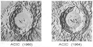 |-
| class="imageCaption" | Elaboration of detail by visual observation (LAC58 details, from Kopal and Carder, 1974)
|}
- To establish a network of 300-m contours for a LAC area, several thousand shadow measurements were needed for each chart. Many photographs of varying Sun angles were required. For this, the Aeronautical Chart and Information Center let a contract with the University of Manchester to establish a lunar photographic program at Pic du Midi Observatory. To support this program ACIC provided a USAF K-22 aerial camera which was modified to take lunar exposures. This was mounted on the Pic du Midi 24-in. refractor. The K-22 camera used 9-in. rolls of film which, after exposure, were forwarded to a USAF Base in France, and subsequently flown to ACIC for processing and measurement. In this way ACIC acquired approximately 60000 time lapsed lunar photographs from 1961 through 1966.
- The first ACIC lunar drawings were reviewed by Gerard Kuiper, then the director of Yerkes Observatory and a lifelong visual observer of the Moon. He advised that it was impossible to interpret fine structure of lunar relief from photographs without visual observations because one can see visually two to three times more than can be seen on the best photograph. ACIC made several trips to Yerkes in the summer of 1960 to observe the Moon with the 40-in. Yerkes refractor but it soon became evident that the number of clear nights at this location would not provide sufficient viewing time to support an extensive lunar mapping program.
- In October 1960 ACIC cartographer William Cannell visited the U.S. Naval Observatory's Flagstaff Station and was permitted to use their 40-in. reflector to observe the Kepler region. The seeing conditions were excellent and every night was crystal clear. Impressive as the Navy's telescope was, it was impossible to consider using it for lunar mapping on a continuing basis because it was heavily scheduled with stellar work. However, USNO Station Director Arthur Hoag suggested that Cannell approach John Hall, director of the nearby Lowell Observatory.
- In the fall of 1960, two lunar charts, LAC-57 Kepler and LAC-75 Letronne were placed in work at ACIC as pilot editions based on telescopic observations. Monthly trips were established for visits to Lowell so that visual observations could be made with their their 24-in refractor during the two or three days required for the terminator to cross the charting area. Usually the morning terminator was observed but occasionally the stay was extended two weeks to observe the same region with the evening Sun. Cannell made most of the observations; sometimes he was assisted by Higgins or Moore of the ACIC Lunar Branch in St. Louis.
- On one trip Cannell was accompanied by Mrs Patricia Bridges who, because of her intense interest in the Moon and her exceptional ability to interpret the lunar forms and render them with an airbrush, became ACIC's lunar illustrator.
- {| class="captionBox"
| class="captionedImage" |
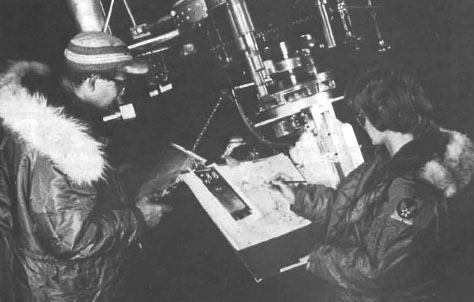 |-
| class="imageCaption" | Cannel and Bridges checking a drawing at the Clark refractor (from Kopal and Carder)
|}
- NASA was favorably impressed with the first 1: 1 000000 scale LACs made from visual observations at Lowell and requested ACIC to map the entire Apollo zone. This was to be a total of ten LACs covering the area from 50° E to 50° W and from 16° N to 16° S. This meant that continuous observations would be required to meet a planned completion date of April 1964. It was estimated that the job could be accomplished by two observers and one illustrator working full time at Lowell Observatory.
- ACIC contracted with Lowell Observatory to provide observing time on their 24-in. refractor and office space to accommodate three persons. Thus, the ACIC Lowell office was officially established on September 1, 1961, and staffed by ACIC personnel William Cannell, James Greenacre and Patricia Bridges. Cannell was placed in charge of the office and tasked along with Greenacre to do the observing while Mrs Bridges was to render the relief drawings. The three made an excellent team and completed five LACs during the first 12 months of operation.
- A telephone link was established between the telescope and the office. Often, when Cannell or Greenacre was observing, Mrs Bridges would be working on the drawing in the office. When seeing conditions became exceptionally good or the illumination of some feature was of particular interest, Mrs Bridges was telephoned to hustle up to the telescope for a first-hand look.
- Visual observations of the Moon were normally made along the terminator and up to approx 30 deg in front of the terminator. The visual observer attempts to record his observations at the telescope by drawing sketches of what he sees or by making notes or annotations on a photograph of a region. When the image is steady with only slow pulsations or swimming motion, the amount of small, fine details that can be seen at one time will usually overwhelm him so that he can do nothing but stare in amazement. At times like this the camera is a most valuable tool.
- It was John Hall, the director of Lowell Observatory, who suggested that a motion picture camera could be used to advantage to supplement visual observations because a large number of photographs taken in rapid sequence would increase the likelihood of catching a portion of the image when it is nearly stationary. A 35-mm motion picture camera was obtained and custom-fitted to the tailpiece of the 24-in. telescope. Thus, the telescope was equipped for both visual and photographic observations. The best image is obtained when the exposure is made precisely during the instant the image is absolutely quiet. This rarely occurs, but by running the camera for a few seconds to obtain a burst of frames, the odds are favorable that some of the frames will record sharp images during a steady moment. Normally some images are taken on each night of observations. When processed the next day they serve to assist the observer because having clearly seen the same area in the telescope he can readily interpret his visual annotations recorded the night before. Later the 35-mm camera was replaced with a 70-mm Hulcher camera which provides a much larger field of view. Greenacre, having some prior photographing experience became the film and print processor.
- {| class="captionBox"
| class="captionedImage" |
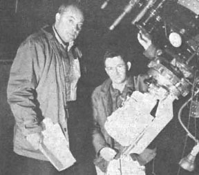 |-
| class="imageCaption" | Greenacre and Barr at the Clark refractor, note the motion picture camera (from Kopal and Carder)
|}
- To keep pace with the rapidly expanding lunar charting workload, ACIC transferred two more cartographers, Leonard Martin and Fred Dungan, to Lowell. With the help of Dungan's airbrush ACIC was rapidly reaching a rate of one LAC every six weeks.
- As the drawing for each LAC was finished, Cannell or Greenacre personally transported it from Flagstaff to the University of Arizona in Tucson for consultation with Kuiper, Arthur and Whitaker. This team of lunar experts, being intimately familiar with the Moon offered constructive suggestions on feature portrayal -a procedure that ACIC followed for each lunar chart drawn from telescopic observations.
- {| class="captionBox"
| class="captionedImage" |
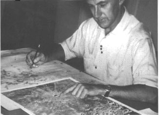 |-
| class="imageCaption" | Ewen Whitaker 'proof reading' an LAC at the LPL in Tucson (from Kopal and Carder)
|}
- Six of the original ten LACs had been completed by the beginning of 1963, but NASA had decided by this time to extend the LAC coverage as far as visual observations would permit. The small ACIC Lowell staff offive persons was insufficient to accomplish the job before the scheduled flight of Apollo. Rather than send more personnel from ACIC in St. Louis, it was decided to contract with Lowell Observatory for increased personnel. Two geographers from the University of Washington were hired in July 1963. The two new selenographers, Terrence McCann and Edward Barr immediately began learning to observe the Moon with the 24-in. refractor. McCann was teamed with Cannell to observe the region near the central meridian and Barr worked with Greenacre in the western limb area.
- 20 Apollo Intermediate Charts spanning the equatorial region from 50°W to 50°W and 8°N to 8°S were also prepared for targeting the forthcoming Lunar Orbiter missions, which would scout for Apollo landing sites. Each AIC detailed one-quarter the area of an LAC, but in the same style.
- It soon became evident that ACIC needed additional telescopic facilities if schedules were to be met. Fortunately, John Hall knew a Texas oil man and amateur astronomer, Benjamin Morgan, who owned a 20-in. Tinsley apochromatic refractor and was willing to sell it. After some tentative agreements were reached with ACIC, Roger Putnam, the trustee of Lowell, agreed to purchase the Morgan 20-in. telescope, move it to Flagstaff and rent it to ACIC. The Morgan 20-in telescope arrived in early 1964; a new dome was built and [stopped to 18-in ?] it was dedicated for lunar work on April 15, 1964. Afterwards, the staff of the ACIC Lowell office was further enlarged and a new building was designed to accommodate as many as 20 persons. Lowell hired a full-time photographer, Robert Maulfair, to assist ACIC.
- ACIC tried to observe the impact of Ranger VII by stationing observers at the 20-in. and 24-in. telescopes and the Lowell 69-in. Perkins reflector, expecting that a large plume of ejecta would be visible even if a sudden flash were not. Others across the country were doing the same thing but no one reported a sighting.
- The need for astrometric photographs to support the ACIC selenodetic program was being met by taking sequential, short exposure photographs with the Pic du Midi 24-in. coude refractor. The 24-in. Lowell refractor could not be used for this program because the scale was too small. The full lunar disc in the Lowell telescope was only 3 in. in diam while in the Pic du Midi telescope it was nearly 7 in. In 1964 it occurred to Cannell that the new Navy 61-in. astrometric telescope located at the Naval Observatory's Flagstaff Station would be ideally suited for this kind of photography. This cooperative program between ACIC and the Navy of taking a few full-moon photographs during each lunation started in 1964 and continued through 1967.
- By July 1966 the work force had grown to 18 persons, but the end of visual observations was in sight. Only seven of the 44 LACs remained to be completed and the Orbiter was getting ready to fly. The first three Orbiters had no influence on the LAC visual observations because they were near the equator while the remaining LACs were in the polar regions. Landing site maps were compiled in St. Louis from the first three Orbiters and the Lowell illustrators were called upon to render them with an airbrush.
- The telescope was virtually obsolete with respect to lunar observations when Orbiter IV flew successfully and returned complete photographic coverage of the near side as well as some 75% of the far side.
- A crash project to produce a new far side lunar map from Orbiters I, II, III, IV and Zond 3 photographs at a 1: 5000000 scale was started in April 1967 and was completed in July in time for NASA to take it to the Prague IAU meeting in August 1967. The Orbiter IV high-resolution photographs were used to finish the remaining few LAC by September 1967.
- By 1968, eight illustrators had learned the Bridges technique of lunar illustration. Over an eight year period they compiled and drafted forty-four LACs and twenty AICs from telescopic observations. In addition, they rendered the drawings for seventeen Ranger charts, six Orbiter Site maps, two Surveyor Site maps and a lunar globe.
- {| class="captionBox"
| class="captionedImage" |
 |-
| class="imageCaption" | Jay Inge drawing gores for the NASA globe in the ACIC office at Lowell Observatory (from Kopal and Carder)
|}
Photographic Basis
- In rendering the lunar surface, the ACIC photographers used all available data, including photos from many sources, apparently primarily from the University of Manchester station they sponsored at Pic du Midi and from their own motion picture films taken at Lowell.
- Other observatories contributing new photos to the LAC effort included the private Stony Ridge Observatory in California (photography done under contract through Lockheed Aircraft), the Kwasan Observatory in Kyoto, Japan, and the Kottomia Station of the Helwan Observatory in Egypt (photography, as at Pic du Midi, done under contract to the University of Manchester).
- The following are prints of sequential "good" and "bad" frames from the motion picture films of Gould obtained at by the ACIC at Lowell, as shown in Kopal and Carder, 1974, which (after visual interpretation and comparison with other resources) presumably contributed to the rendering in LAC 94. For comparison, the same region is shown as later photographed by the LPL's 61-inch reflector and printed as Plate F15 in the Consolidated Lunar Atlas.
- {| class="captionBox"
| class="captionedImage" |
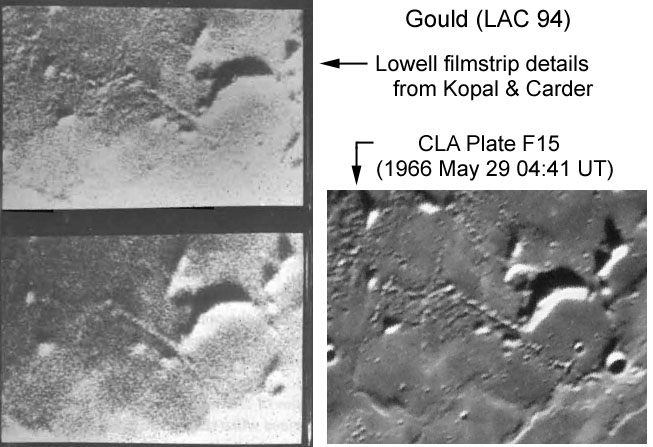 |-
| class="imageCaption" | Comparison of ACIC Lowell imagery (from Kopal and Carder) with later photo by LPL
|}
- The Lowell filmstrip seems decidedly inferior to the later CLA plate. The photos from Pic du Midi, at least as reproduced in Kopal's Photographic Atlas of the Moon, seem similar in quality to the Lowell example. For example, they show few, if any, craterlets on the floor of Plato. This compares to 8 or so craterlets detectable in the CLA plates, and about 24 in the ACIC's airbrush rendering of Plato's floor in LAC 12, including one indicated as a control point at the foot of the west wall. Unfortunately, the existence of most of the craterlets added to LAC 12 by visual "enhancement" of the photographic record were not verified by space-based photography (see for example, the Lunar Orbiter photo used as the basis for the modern IAU nomenclature map). As a result, despite their general usefulness, this leaves the LAC's a bit like a road atlas depicting small secondary routes which may or may not have ever existed.
Accuracy
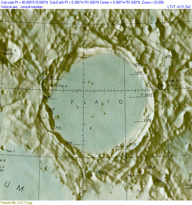
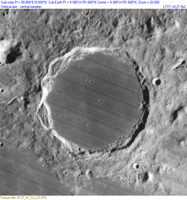
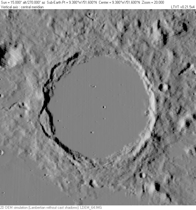
Despite the best efforts of the ACIC, the end product shows considerable fine detail that could not be verified in satellite images. As a somewhat random example, click the following thumbnails to compare the region around Plato as portrayed in LAC 12 with the detail later photographed with lighting from the east by Lunar Orbiter (frame LOIV-127H) and a constant western lighting simulation (without cast shadows -- similar to the intent of the LAC renderings) based on LOLA topographic data:
| LAC 12 |
LOIV-127H |
LOLA |
Although arguably a better representation than any earlier map, the Plato craterlets are not entirely accurate, and fine detail in the surrounding area is even less so. For example, from the LAC one would expect the largest craterlet on the floor to be the 2.8 km diameter one depicted near the slump block in the west rim (once known as Plato Zeta), but it is not double (as shown), and it is actually (true size 1.8 km) considerably smaller than one near the center (which is plotted at a diameter of 2.1 km but whose true size -- 2.4 km -- dominates its neighbors). As with older maps, still smaller craters shown on the floor are sufficiently misplaced it becomes difficult to be sure which (if any) real ones they correspond to. In the rougher areas surrounding Plato, craters drawn with diameters up to 5 to 7 km cannot be trusted to exist.
LPOD Articles
Bibliography
- ACIC. 1965. "Lunar Charting Program: Quarterly Progress Report No. 4: 1 April 1965 - 20 June 1965." (PDF)
- Anon. 1960. "St. Louis-Made Moon Maps For First U.S. Spaceman." St. Louis Post-Dispatch (6 November 1960, Sunday supplement).
- Batson, R. M. 1978. "Planetary Mapping with the Airbrush." Sky and Telescope. Vol. 55, No. 2 (February issue), pp. 109-112.
- Carder, R. W. 1962. Lunar Charting on a Scale of 1:1000000. In: The Moon, (Kopal, Z., and Mikhailov, Z. K., editors) IAU Symposium 14, Academic Press, pp. 117-129. (detailed information on how the first LAC's were produced)
- Carder, R. W. and Scott, S. P. 1966. Lunar Charting for Project Apollo. Navigation, Vol. 13, No. 1 (Spring issue), pp. 49-58.
- Eriksen, J. G. 1965. "Lunar charting". Air Univ. Rev., 16, p. 76.
- Goodyear, J. 1963. Trail Blazers for Moon Explorers. Popular Mechanics. Feb. issue, pp. 128ff (lunar mapping efforts for Apollo program)
- Inge, J. L.; Bridges, P. M. 1976. Applied photo interpretation for airbrush cartography. In: American Society of Photogrammetry and American Congress on Surveying and Mapping, Fall Convention, Phoenix, Ariz., October 26-31, 1975, Proceedings. (A76-38501 19-43) Falls Church, Va., American Society of Photogrammetry, 1976, p. 244-265.
- Kopal, Zdenek; Carder, Robert W. 1974. Mapping of the moon. Past and present. Astrophysics and Space Science Library, Dordrecht: Reidel.
- Kuiper, G. P. 1972. "The Lunar and Planetary Laboratory and Its Telescopes." Communications of the LPL No. 172 (PDF)
- Pace, Eric. 1993. "Zdenek Kopal, A Lunar Expert And Author, 79". New York Times on-line.
- Rackham, Tom. 1962. Installing a Big Telescope for Moon Research. New Scientist Feb 15 issue.
- Schimerman, Lawrence A., ed., 1973, Lunar Cartographic Dossier, Volume I, NASA and the Defense Mapping Agency, St. Louis, Missouri. With changes and additions to 1977 July. (approx. 359 pp).
- St. Clair, J. H.; Carder, R. W.; Schimerman, L. A. 1979. United States lunar mapping - A basis for and result of project Apollo. Moon and the Planets, vol. 20, Apr. 1979, p. 127-148.
- Weir, Gary E. 2009. Our Heritage: Lunar Cartography Informed Early Space Program. NGA Pathfinder Nov-Dec.
- Wright, F. E., Wright, F. H. and Wright, Helen. 1963. "The Lunar Surface: Introduction" in Middlehurst, Barbara. The moon, meteorites, and comets. The solar system / ed. by Gerard P. Kuiper, Vol. 4. Chicago, Ill: Univ. of Chicago Press.
- Kuiper archive
- Zdenek Kopal papers (details)
