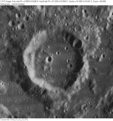
Lohrmann
Contents
[hide]Lohrmann
|
Lat: 0.5°S, Long: 67.2°W, Diam: 30 km, Depth: 1.31 km, Rükl 39 |
Images
LPOD Photo Gallery Lunar Orbiter Images
- Apollo 17's orbital NIKON-camera photograph AS17-158-23900 (made in earthlight) shows Lohrmann in the foreground. The dark spot near the curved horizon is Riccioli's floor.
- Research Danny Caes
Maps
(LAC zone 74A1) LAC map Geologic map
Description
Description: Elger
(IAU Directions) LOHRMANN.--This ring-plain, with Hevel(ius) and Cavalerius on the N. of it, is a member of a linear group, which, but for its propinquity to the limb, would be one of the most imposing on the moon's surface. Lohrmann, about 28 miles in diameter, is surrounded by a bright wall, which, to all appearance, is devoid of detail. Two prominent ridges, with a fine intervening valley, connect it with the N. end of Grimaldi. It has a large but not conspicuous central mountain. On the rugged surface, between the ring-plain and the W. edge of the Oceanus Procellarum, lies a very interesting group of crossed clefts, some of which run from N.W. to S.E., and others from N.E. to S.W. Three of the latter proceed from different points in a coarse valley extending from E. to W., and cross the ridges just mentioned. They follow a parallel course, and terminate on the S. side of a crater-row, consisting of three bright craters ranging in a line parallel to the coarse valley. On the N. side of these objects, and tangential to them, is another cleft, which traverses the E. and W. walls of Lohrmann, and, crossing the region between it and Riccioli, terminates apparently at the E. wall of the latter formation. No map shows this cleft, though it is obvious enough; and, when the W. wall of Hevel(ius) is on the morning terminator, the notches made by it in the border of Lohrmann are easily detected. Capt. Noble, F.R.A.S., aptly compares two of the crossed clefts to a pair of scissors, the craters at which they terminate representing the oval handles. On the grey surface of the Mare E. of Lohrmann is the bright crater Lohrmann A, from which, running N., proceeds a rill-like valley ending at a large white spot, which has a glistening lustre under a high light.
Description: Wikipedia
Additional Information
- Depth data from Kurt Fisher database
Westfall, 2000: 1.31 km - Satellite crater Lohrmann A is on the ALPO list of bright ray craters.
- Lohrmann A is also a thermal anomaly crater, implying a youthful age - Moore et al, 1980
- East-southeast of the bright crater Lohrmann A, at 1° South/ 61° West, is the location of a curious little swirl which could be part of Reiner Gamma's southwestern extension. Research Danny Caes. See also LPOD Swirlette.
Nomenclature
- Wilhelm Gotthelf Lohrmann (January 31, 1796–February 20, 1840) was a Saxon cartographer, astronomer, meteorologist and patron of the sciences. In 1821 he made observations of the Moon, enabling him to produce a Mondkärtchen (lunar map). The first four sections of a proposed 25-sheet map at a scale of three feet to the lunar diameter appeared in 1824 as Topographie der sichtbaren Mondoberfläche ("Topography of the visible surface of the moon"). The remaining sections were completed by 1836, but not published during Lohrmann's lifetime. The appearance of Lohrmann's 25 sections, printed as a 38.5 cm (15 1/4") diameter Kleine Karte des Mondes ("Small map of the Moon") in 1838, was probably overshadowed by Beer and Mädler's 38 inch Mappa Selenographica (1834-1836). In 1878, Julius Schmidt (with help from F. W. Opelt, and then his son Moritz) edited and published all 25 sheets of Lohrmann's map at their original scale as Mondcharte in 25 Sectionen. These were re-issued in 1892 and republished in 1963. According to Birmingham's 1878, Schmidt omitted Lohrmann's biographical history of the names and much of his descriptive text, as well as deleting some of the names from the maps and making other alterations (including, possibly, adding some names suggested by himself and the Opelts).
- Swirlette (a nickname for the small Reiner Gamma type swirl east-southeast of Lohrmann A), see: http://bit.ly/2oo6g7D
Miyamori Valley
- West of Lohrmann, running toward Riccioli, is a formation which is sometimes called the Miyamori Valley. Although this name is not official, it is mentioned in several Moon books, such as Harold Hill's A Portfolio of Lunar Drawings, page 138 (drawing page 139).
LPOD Articles
Bibliography
- Anon. 1878. Description of prospectus issued prior to publication of Lohrmann's map set.
- Anon. 1878. Advertisment for 25-sheet map set, and a separate booklet and map by 0. M. Oppelt.
- Anon. 1878. Lohrmann's Moon Charts. The Academy, Issue 13. -- (review of publication and its history)
- Anon. 1878. W. G. Lohrmann's Mondcharte Sirius: Zeitschrift für populäre Astronomie, Volume 11, pp. 73-79. -- very thorough review (in German)
- Birmingham, J. 1878. Lohrmann's Lunar Map. Astronomical register, vol. 16, pp. 197-198.
- Bruns, C. 1878. W. G. Lohrmann: Mondcharte. Jenaer Literaturzeitung, Volume 5, Nr. 17, pp. 252-253. -- extended review (in German)
- Fischer, Walther. 1987. Lohrmann, Wilhelm Gotthelf in: Neue Deutsche Biographie 15, S. 137-138. (online - in German)
- Hill, Harold. A Portfolio of Lunar Drawings, pages 138, 139 (the "Miyamori valley" region).
