Difference between revisions of "Montes Doerfel"
| Line 2: | Line 2: | ||
=Montes Doerfel= | =Montes Doerfel= | ||
''(discontinued [[IAU|IAU]] name; former IAU name '''Doerfel Mountains''')''<br /> <div id="toc"> | ''(discontinued [[IAU|IAU]] name; former IAU name '''Doerfel Mountains''')''<br /> <div id="toc"> | ||
| − | + | ||
| − | |||
{| class="wiki_table" | {| class="wiki_table" | ||
| | | | ||
| Line 25: | Line 24: | ||
* A peculiar [[clair-obscur|clair-obscur]] effect on Doerfel Gamma in a waning lunar crescent was drawn by Harold Hill (see bibliography below). | * A peculiar [[clair-obscur|clair-obscur]] effect on Doerfel Gamma in a waning lunar crescent was drawn by Harold Hill (see bibliography below). | ||
* On [http://books.google.com/books?id=cj8_bPbiiacC&lpg=PA130&pg=PA131#v=onepage&q&f=false page 132] of Harold Hill's splendid book ''[[A%20Portfolio%20of%20Lunar%20Drawings|A Portfolio of Lunar Drawings]]'' there's an interesting telescopic observation of a shadowed (yet dimly illuminated) mountain range at the moon's south-southwestern limb ("behind" [[Bailly|Bailly]]) -- the '''Montes Doerfel''' -- as observed during the pre-dawn hours of September 27th, 1951. It shows the '''Dorfel''' range with five sunlit peaks, and the lower part of the mountain's mass in a dim light which Mr. Hill thought could have been [[Earthshine|Earthshine]] (at that day in 1951, the moon was at its ''Waning Crescent'' [[phase|phase]], and, as seen from the moon, the Earth should have been at ''Waxing Gibbous''). Could it (this weak illumination) have been a combination of Earthshine and reflected light of nearby sunlit slopes slightly east of the Dorfel range? Research Danny Caes. | * On [http://books.google.com/books?id=cj8_bPbiiacC&lpg=PA130&pg=PA131#v=onepage&q&f=false page 132] of Harold Hill's splendid book ''[[A%20Portfolio%20of%20Lunar%20Drawings|A Portfolio of Lunar Drawings]]'' there's an interesting telescopic observation of a shadowed (yet dimly illuminated) mountain range at the moon's south-southwestern limb ("behind" [[Bailly|Bailly]]) -- the '''Montes Doerfel''' -- as observed during the pre-dawn hours of September 27th, 1951. It shows the '''Dorfel''' range with five sunlit peaks, and the lower part of the mountain's mass in a dim light which Mr. Hill thought could have been [[Earthshine|Earthshine]] (at that day in 1951, the moon was at its ''Waning Crescent'' [[phase|phase]], and, as seen from the moon, the Earth should have been at ''Waxing Gibbous''). Could it (this weak illumination) have been a combination of Earthshine and reflected light of nearby sunlit slopes slightly east of the Dorfel range? Research Danny Caes. | ||
| − | ** ''Note: Hill's drawing of the five sunlit peaks seems somewhat fanciful when compared to [http://ltvt.wikispaces.com/file/detail/HaroldHill_p132_Bailly_Doerfels_simulation.jpg this simulation], which is likely to be [http://the-moon.us/wiki/North+Pole#StefanLammelPhoto very similar] to how the Moon would have looked in a photo taken at the time of his observations. The approach of daylight on Earth may have affected how the features appeared visually.''<span class="membersnap">- | + | ** ''Note: Hill's drawing of the five sunlit peaks seems somewhat fanciful when compared to [http://ltvt.wikispaces.com/file/detail/HaroldHill_p132_Bailly_Doerfels_simulation.jpg this simulation], which is likely to be [http://the-moon.us/wiki/North+Pole#StefanLammelPhoto very similar] to how the Moon would have looked in a photo taken at the time of his observations. The approach of daylight on Earth may have affected how the features appeared visually.''<span class="membersnap">- Jim Mosher</span> |
* Description by Harold Hill: | * Description by Harold Hill: | ||
** '''''The Dorfel range''': the old appellation for these mountains, which actually form the ramparts of [[Hausen|Hausen]] and other large rings in this region.'' | ** '''''The Dorfel range''': the old appellation for these mountains, which actually form the ramparts of [[Hausen|Hausen]] and other large rings in this region.'' | ||
| − | * Descriptions of the latitude range over which the Doerfels extend differ widely, so the exact identity of the intended peaks intended by various authors is not clear. <span class="membersnap">- | + | * Descriptions of the latitude range over which the Doerfels extend differ widely, so the exact identity of the intended peaks intended by various authors is not clear. <span class="membersnap">- Jim Mosher</span> |
<br /> | <br /> | ||
==Nomenclature== | ==Nomenclature== | ||
| Line 55: | Line 54: | ||
[http://the-moon.us/wiki/file/detail/Schroter_Doerfel_peaks_1789Aug12_aerial.JPG [[Image:Schroter_Doerfel_peaks_1789Aug12_aerial.JPG|external image Schroter_Doerfel_peaks_1789Aug12_aerial.JPG?size=64]]]<br /> | [http://the-moon.us/wiki/file/detail/Schroter_Doerfel_peaks_1789Aug12_aerial.JPG [[Image:Schroter_Doerfel_peaks_1789Aug12_aerial.JPG|external image Schroter_Doerfel_peaks_1789Aug12_aerial.JPG?size=64]]]<br /> | ||
|} | |} | ||
| − | <br /> Schröter [http://books.google.com/books?id=T6oaAAAAYAAJ&pg=PA129#v=onepage&q&f=false next looked] for the peaks on November 15, 1788 and again on January 12, 1789, but saw only a single peak at those times, which is consistent with the above identifications. On August 12, 1789, when the libration was very similar to his initial view, he made a daytime observation of the limb and again noted the four peaks as shown in the middle simulation. This is "unrolled" to an aerial view in the final image, where the locations of the features producing the labeled peaks in the first two simulations is indicated relative to modern [[IAU|IAU]]-named features (represented by a gray-scale version of the topographic heights, white being high, and black low). The blue line is the theoretical limb, with most of the area above the line visible from Earth.<br /> <br /> ''Note: the preceding was based entirely on a reading, by a person with little knowledge of German, of the verbal description in the on-line scan of Volume 1 of Schröter's book. The words refer to plate T. IV, in which Schröter illustrated these and other observations. Reproductions of that plate do not appear to be available on-line, however a [http://the-moon.us/wiki/file/detail/Schroeter_T_IV-NigelLongshawScan_reduced.jpg scan] of T. IV has recently been made available by [http://www.mikeoates.org/mas/cn/lunabooks/home.htm Nigel Longshaw], and it confirms that the Fig. 5 drawing, and its lettering, match the October 15, 1788 simulation (although rotated, and the "delta" peak is not shown in the simulation). Plate [http://gallica.bnf.fr/ark:/12148/btv1b2600117x.item.f46.pagination.langEN TL] (part of Volume 2) appears to show the Sun rising over the limb peaks near [[Bailly|Bailly]], but the text that accompanies it is not currently available on-line.''<span class="membersnap">- | + | <br /> Schröter [http://books.google.com/books?id=T6oaAAAAYAAJ&pg=PA129#v=onepage&q&f=false next looked] for the peaks on November 15, 1788 and again on January 12, 1789, but saw only a single peak at those times, which is consistent with the above identifications. On August 12, 1789, when the libration was very similar to his initial view, he made a daytime observation of the limb and again noted the four peaks as shown in the middle simulation. This is "unrolled" to an aerial view in the final image, where the locations of the features producing the labeled peaks in the first two simulations is indicated relative to modern [[IAU|IAU]]-named features (represented by a gray-scale version of the topographic heights, white being high, and black low). The blue line is the theoretical limb, with most of the area above the line visible from Earth.<br /> <br /> ''Note: the preceding was based entirely on a reading, by a person with little knowledge of German, of the verbal description in the on-line scan of Volume 1 of Schröter's book. The words refer to plate T. IV, in which Schröter illustrated these and other observations. Reproductions of that plate do not appear to be available on-line, however a [http://the-moon.us/wiki/file/detail/Schroeter_T_IV-NigelLongshawScan_reduced.jpg scan] of T. IV has recently been made available by [http://www.mikeoates.org/mas/cn/lunabooks/home.htm Nigel Longshaw], and it confirms that the Fig. 5 drawing, and its lettering, match the October 15, 1788 simulation (although rotated, and the "delta" peak is not shown in the simulation). Plate [http://gallica.bnf.fr/ark:/12148/btv1b2600117x.item.f46.pagination.langEN TL] (part of Volume 2) appears to show the Sun rising over the limb peaks near [[Bailly|Bailly]], but the text that accompanies it is not currently available on-line.''<span class="membersnap">- Jim Mosher</span><br /> <br /> |
==LPOD Articles== | ==LPOD Articles== | ||
<br /> | <br /> | ||
| Line 65: | Line 64: | ||
<br /> <br /> | <br /> <br /> | ||
---- | ---- | ||
| − | + | </div> | |
Revision as of 16:39, 15 April 2018
Contents
Montes Doerfel
(discontinued IAU name; former IAU name Doerfel Mountains)|
Lat: 60-80S, Long: 90W, Length: km, Height: km, Rükl 71 |

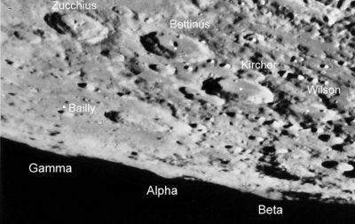
Consolidated Lunar Atlas The peaks are labeled as named by Schröter (see below). A fourth peak, Delta, is out of the field to the left.
Images
- The August 11, 2008 LPOD features an excellent Earthbased red-blue stereo image of Montes Doerfel from the AstronoMinsk imagers. The peaks Beta, Alpha, Gamma and Delta of Schröter, Neison, and (formerly) the IAU can be seen arrayed from left to right.
- The May 11, 2008 LPOD shows the Montes Doerfel peaks from an unusual space-based perspective, with the Kaguya HDTV camera looking roughly northward along the mean limb, from Drygalski. The former Doerfel Beta is seen protruding out of the rim of Drygalski at around the 10 o'clock position, with the sharper peak of Alpha behind it, sticking partly above the limb. Gamma is seen as a broad mass on the horizon (to the right of Alpha), with the highly foreshortened crater Boltzmann recognizable, with some effort, in front of it, a little to the right.
- Alpha, Gamma and Delta are on the limb in the August 4, 2008 LPOD.
- Gamma is well onto the disk with the stronger libration of the June 10, 2010 LPOD. Alpha is the second sharp peak from the right. The smaller cratered peak to its left not part of the classic Doerfels -- it is a farside peak near Zeeman R, at about 72.4°S/119.2°W.
Maps
(LAC zone 143B3)
Description
Suspected mountain range near the moon's southwestern limb (near Bailly).
Description: Elger
(IAU Directions) DORFEL MOUNTAINS.--On the S.W. limb between S. lat. 57 deg. and S. lat. 80 deg.
Additional Information
- A peculiar clair-obscur effect on Doerfel Gamma in a waning lunar crescent was drawn by Harold Hill (see bibliography below).
- On page 132 of Harold Hill's splendid book A Portfolio of Lunar Drawings there's an interesting telescopic observation of a shadowed (yet dimly illuminated) mountain range at the moon's south-southwestern limb ("behind" Bailly) -- the Montes Doerfel -- as observed during the pre-dawn hours of September 27th, 1951. It shows the Dorfel range with five sunlit peaks, and the lower part of the mountain's mass in a dim light which Mr. Hill thought could have been Earthshine (at that day in 1951, the moon was at its Waning Crescent phase, and, as seen from the moon, the Earth should have been at Waxing Gibbous). Could it (this weak illumination) have been a combination of Earthshine and reflected light of nearby sunlit slopes slightly east of the Dorfel range? Research Danny Caes.
- Note: Hill's drawing of the five sunlit peaks seems somewhat fanciful when compared to this simulation, which is likely to be very similar to how the Moon would have looked in a photo taken at the time of his observations. The approach of daylight on Earth may have affected how the features appeared visually.- Jim Mosher
- Description by Harold Hill:
- The Dorfel range: the old appellation for these mountains, which actually form the ramparts of Hausen and other large rings in this region.
- Descriptions of the latitude range over which the Doerfels extend differ widely, so the exact identity of the intended peaks intended by various authors is not clear. - Jim Mosher
Nomenclature
- Named for Georg Samuel Doerfel (1643-1688), a German astronomer. See Doerfel.
- These peaks were originally named by Johann Schröter (see Schröter's observations, below).
- Beer and Mädler do not seem to have understood Schröter's description of either the Doerfels or the Leibnitz Mountains (to their east), interchanging the two. A diagram illustrating this reversed definition can be found in Mädler's article about the partial solar eclipse of 1833; and a list of his Randberge (limb mountain) positions can be found at the end of a longer article from May, 1837.
- Neison, 1876 labeled the Doerfel peaks in a manner consistent with Schröter.
- The Doerfel Mountains were catalog number 2660 in Mary Blagg's Collated List, and were part of the original IAU Nomenclature of 1935, which included four Doerfel peaks: Alpha, Beta, Gamma and Delta; probably based on Neison's depiction.
- The name was Latinized to Montes Doerfel in 1964 (IAU Transactions XIIB); however six years later it was dropped as one of "a number of mountain ranges ... found not to be clearly identifiable" (IAU Transactions XIVB, 1970).
- The name Montes Doerfel is still printed on some of the modern Moon maps, such as the Hallwag map and others.
- Also called The Dorfels or The Dorfel range.
Schröter's Observations
Johann Schröter, "discoverer" of the Doerfel Mountains, was a meticulous observer who left careful records of his observations, including the date and time at which they were made, and such things as a record of the observed librations by means of noting how far Plato and Grimaldi were offset from the limb. The date and time makes it easy to reconstruct what he must have seen based on data on the shape of the Moon's surface returned by instruments on the Kaguya and LRO spacecraft (as added proof, see this simulation of the expected appearance of the limb at the time of the Consolidated Lunar Atlas photo reproduced above).
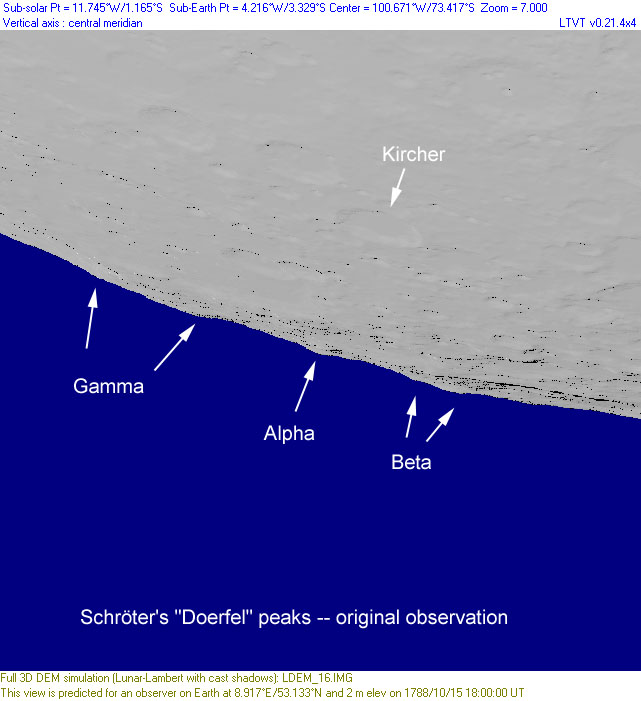
In the case of the Doerfel peaks, Schröter's initial observation was on October 15, 1788 at about 18:00 UT, at which time he saw three relatively prominent peaks along the Moon's limb. He called these Doerfel Alpha (central peak), Beta (to east of Alpha) and Gamma (to west of Alpha), noting that a straight line from Tycho through Kircher crossed the limb at Doerfel Alpha. He also carefully recorded the width and spacing of the peaks (as well as their heights), and noted a possible fourth peak to the west of of Gamma. This careful description unambiguously identifies the peaks as shown in the first simulation, below.
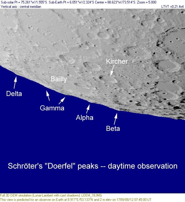
| Oct 15 1788 |
Aug 12 1789 |
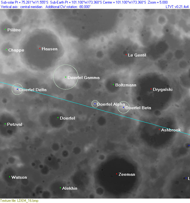
Aerial View |
Schröter next looked for the peaks on November 15, 1788 and again on January 12, 1789, but saw only a single peak at those times, which is consistent with the above identifications. On August 12, 1789, when the libration was very similar to his initial view, he made a daytime observation of the limb and again noted the four peaks as shown in the middle simulation. This is "unrolled" to an aerial view in the final image, where the locations of the features producing the labeled peaks in the first two simulations is indicated relative to modern IAU-named features (represented by a gray-scale version of the topographic heights, white being high, and black low). The blue line is the theoretical limb, with most of the area above the line visible from Earth.
Note: the preceding was based entirely on a reading, by a person with little knowledge of German, of the verbal description in the on-line scan of Volume 1 of Schröter's book. The words refer to plate T. IV, in which Schröter illustrated these and other observations. Reproductions of that plate do not appear to be available on-line, however a scan of T. IV has recently been made available by Nigel Longshaw, and it confirms that the Fig. 5 drawing, and its lettering, match the October 15, 1788 simulation (although rotated, and the "delta" peak is not shown in the simulation). Plate TL (part of Volume 2) appears to show the Sun rising over the limb peaks near Bailly, but the text that accompanies it is not currently available on-line.- Jim Mosher
LPOD Articles
Bibliography
- Hill, H. A Portfolio of Lunar Drawings (Cambridge, 1991), pages 130-131 (Bailly and the Dörfels).
- Wanders, A.J.M. Op Ontdekking in het Maanland, Moon map: quadrant III, d-1. ("Doerffel gebergte").
- Whitaker, E. A. Mapping and Naming the Moon (Cambridge, 1999).


