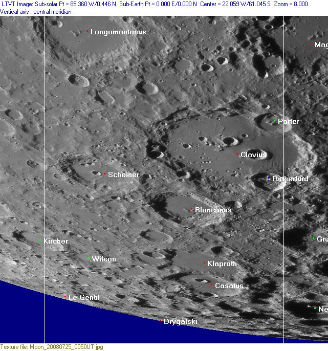
Rükl 72
Contents
Rükl Zone 72 - CLAVIUS
Neighboring maps on the Rükl Nearside Map:
| 72 |
||
Photographic Map
(This map is based on an Earth-based photograph that has been computer-corrected to zero libration. The vertical white lines indicate the left and right boundaries of the Rükl rectangle)

  Background image source
Nearside Named Features
- Arabia (regio) (J.Hewelcke's disallowed name for the south-southwestern limb area).
- Bailly-Newton Basin (an unofficial name).
- Blancanus (Van Langren's Ferdinandi Elect. Col., J.Hewelcke's Vallis Hajalon).
- Bonestell (J.Westfall's unofficial name for Cabeus B, see also the section Additional Information at the lower part of Rukl's 73).
- Casatus (Van Langren's Anselmi Elect. Mogunt.).
- Chandrayaan-2's possible landingsite, east of Klaproth A, see: http://bit.ly/2FIm6jZ
- Clavius (Van Langren's Maximiliani Duc. Bava., J.Hewelcke's Desertum Hevila).
- According to Chart 107 in the Times Atlas of the Moon, a tiny hill on the floor of Clavius (west of Clavius D) seems to have been called Clavius Theta.
- Desertum Raphidim (J.Hewelcke's disallowed name for the western part of Clavius).
- Drygalski
- Klaproth
- Luna Incognita (an unofficial name, see also Chart 73).
- Le Gentil
- Longomontanus (Van Langren's Ioanni D. Sax., J.Hewelcke's Mons Annae).
- Porter (C.Gaudibert's Draper).
- Rutherfurd
- Scheiner (J.Hewelcke's Vallis Hajalon).
- Terra Fertilitatis (Riccioli's discontinued name for the whole of Chart 72).
- Wilson
Farside Named Features
(The following features are not formally included in the present Rükl rectangle, but they are adjacent to it and their centers are less than 10° beyond the mean limb -- so they may be seen here in whole or in part with a favorable libration)
Lettered Crater Locations
(click on the thumbnails to view full-sized images; use browser BACK button to return to this page)
Full zone with lettered craters
Lettered craters by quadrants
(the dashed white lines are the centerlines of the Rükl zones)
| North West |
North East |
| South West |
South East |
Additional Information
- Other online descriptions of features in this Rükl map section:


