Montes Cordillera
Contents
Montes Cordillera
(former IAU name: Cordillera Mts)
|
Lat: 19.6°S, Long: 94.7°W, Diam: 945 km (see note), Height: 6 km, Rükl: 50 |
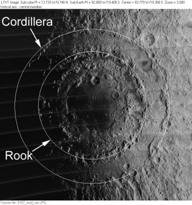
LO-IV-187M The circles superimposed on this Lunar Orbiter view indicate what are probably most usually taken to be the IAU's Montes Cordillera and Montes Rook ranges around Mare Orientale. Montes Rook probably includes the ring of peaks inside the inner circle, a formation known to many lunar geologists as the Inner Rook Ring.
Images
LPOD Photo Gallery Lunar Orbiter Images Apollo Images
Maps
(LAC zone 108B2) In USGS Digital Atlas mapped on LAC-90 PDF, LAC-73 PDF, LAC-108 PDF, and LAC-91 PDF. For an overview see Farside PDF. See also the older LMP-1 and LMP-2.
Description
Elger
(IAU Directions) THE CORDILLERAS.--Close to the W. limb; they lie between S. lat. 8 deg. and S. lat. 23 deg.
Wikipedia
Additional Information
- The position and coordinates given in the title line (and illustrated in the Lunar Orbiter image) differ from those in given on the IAU page.
- The names Rook and Cordillera were originally given by Earth-based observers, but lunar geologists using Lunar Orbiter overhead views made the distinction between the Inner Rook and Outer Rook Mountains because there are two different rings. The smaller circle on the diagram above is the Outer Rooks, and the more fragmentary 480 km wide Inner Rook chain is easily visible inside it. From Earth these looked like one mountain chain. The offical IAU nomenclature just has Rook Mountains - the IAU is about 40 years behind science in recognizing that there are two Rook rings. Some lunar scientists interpret the conspicuous Cordillera as the main rim of the Orientale Basin, others think that the hilly material in the moat between the Cordillera and Outer Rook is basin ejecta, therefore the Outer Rook would be the main rim. See Orientale Basin for more information. - tychocrater Oct 30, 2007
- Depth data from Kurt Fisher database
- Viscardy, 1985: 6 km
- Cherrington, 1969: 6.09 km
Nomenclature
- "Cordillera" is Spanish for "mountain chain".
- Cordillera Mts. was included in the original IAU nomenclature of Blagg and Müller. It was No. 2029 in Blagg's Collated List, where she notes the name was used by Beer and Mädler. According to Baum and Whitaker (p. 132), Beer and Mädler applied this name to the region between the modern Eichstadt and Schlüter, which they depicted as a continuous range of mountains. The name may have been inspired by Schröter's earlier mention of having observed a "sehr hohen Mondcordilleren" in this vicinity (ibid, p. 130).
- The understanding of the Cordillera Mts by early 20th century observers trying to follow the IAU nomenclature did not necessarily correspond to the present understanding of the term. For example, Wilkins and Moore place the Cordillera Mts well to the south, on the far side of Mare Orientale, at the limit of what can be seen at the most favorable libration. This most likely corresponds to farside peaks of the inner rings. They place the Rook Mts still farther south, and at a similarly extreme longitude, corresponding possibly to some of the more distant parts of the present Montes Cordillera. The peaks on the nearside of Mare Orientale are not named. The Army Map Service's early LTM series (attempting to illustrate the Blagg and Müller nomenclature) placed these features in the same way (see LTM-2 and Shaded Topo 2).
- As noted by Whitaker (p. 235), the Cordillera Mts. was among the features the LPL felt were inadequately identified in Named Lunar Formations, and they "moved" the name to the feature(s) intended by the "original authority" (Mädler, in this case). These changes were published in Table III of their Photographic Lunar Atlas, and approved by the IAU in 1961 (IAU Transactions XIB).
- The name was Latinized to Montes Cordillera in 1964 (IAU Transactions XIIB).
- Since the name is not mentioned in any subsequent IAU Transactions, it is not entirely clear if the IAU name was ever meant to include the full extent of the ring made visible by the views from space. A 1969 written memo by the then Lunar Nomenclature Working Group chairman suggests this was the intention, but it does not seem to have been voted on (see Mare Orientale Nomenclature).
- The "definition" of Montes Cordillera indicated by the circle shown above agrees with the labeling of this feature in the unofficial USGS Digital Atlas, which seems to be based on NASA's LMP-1 and LMP-2 (prepared by the DMA).
- Lunar geologists, whose terminology does not always correspond to the IAU names (see, for example, Apennine Front), typically refer to the complete ring as the Cordillera Ring, or, less commonly, the Cordillera Mountains. Head (1974) also suggests the alternative name Eichstadt Ring (after the crater on the rim. They assign this ring a diameter of 900 km (Head, 1974) to 930 km (Bussey and Spudis, 1997).
- On Hans Schwarzenbach's lunar farside map of Hallwag, Montes Cordillera is printed as Montes Cordilleres.- DannyCaes Oct 24, 2010
- Montes Cordillera seems to be a difficult name, because it is mentioned as Montes Cordellaris on page 177 of Charles J. Byrne's The Far Side of the Moon; a Photographic Guide (Springer, 2008). Hmmm... Montes Cordellaris... On page 174 it is mentioned as Montes Cordillara. - DannyCaes Dec 9, 2017
LPOD Articles
The Edge of a Bull's Eye A Mountain Range or a Scarp? Rims on the Limb An Overlooked Gem
- (see Mare Orientale for additional LPOD links)
Bibliography
- Baum and Whitaker, 2007
- Bussey, D.B.J. & P.D. Spudis. 1997. Compositional analysis of the Orientale basin using full resolution Clementine data: Some preliminary results. Geophysical Research Letters v24, p445-448.
- Head, J.W. 1974. Orientale multi-ringed basin interior and implications for the petrogenesis of lunar highland samples. Earth, Moon, and Planets v. 11 p327-356.
Named Features -- Prev: Copernicus -- Next: Cori
