Rükl 37
Contents
Rükl Zone 37 - TARUNTIUS
Neighboring maps on the Rükl Nearside Map:
Table of Contents
[#Rükl Zone 37 - TARUNTIUS Rükl Zone 37 - TARUNTIUS]
[#Rükl Zone 37 - TARUNTIUS-Photographic Map Photographic Map]
[#Rükl Zone 37 - TARUNTIUS-Named Features Named Features]
[#Rükl Zone 37 - TARUNTIUS-Lettered Crater Locations Lettered Crater Locations]
[#Rükl Zone 37 - TARUNTIUS-Additional Information Additional Information]
[#Rükl Zone 37 - TARUNTIUS-Apollo 15's CSM Endeavour over Taruntius and Asada Apollo 15's CSM Endeavour over Taruntius and Asada]
[#Rükl Zone 37 - TARUNTIUS-Mount Marilyn Mount Marilyn]
| 37 |
||
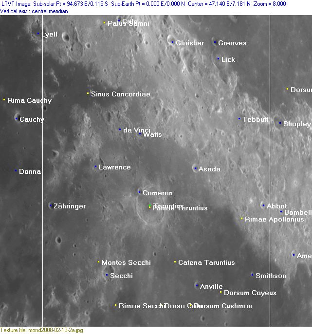
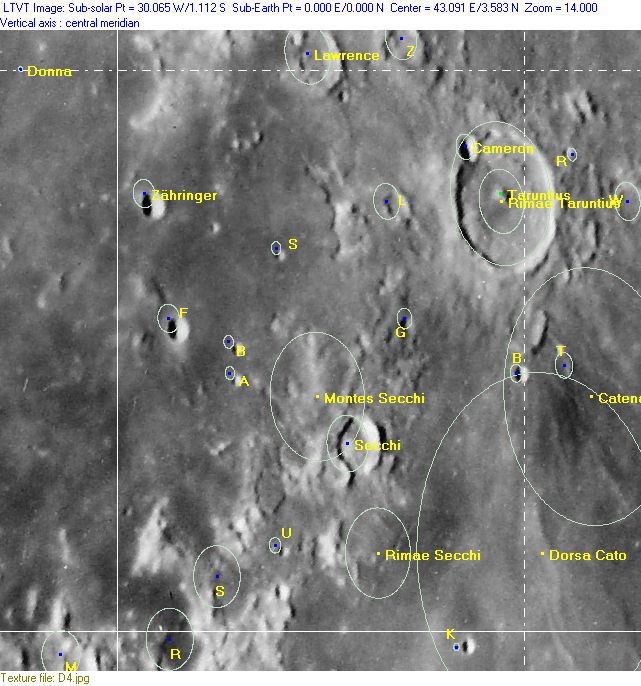
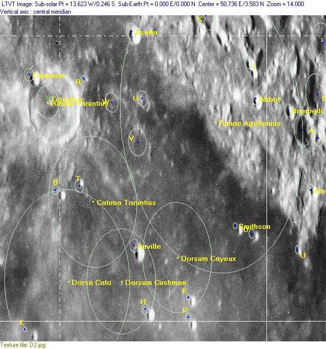
Photographic Map
(This map is based on an Earth-based photograph that has been computer-corrected to zero libration. The vertical white lines indicate the left and right boundaries of the Rükl rectangle)

  Background image source
Named Features
- Abbot
- Anville
- Anville group / Gang of Four (two nicknames from D.Caes for the four bowl-shaped craters Anville, Taruntius H, Taruntius K, and Taruntius P).
- Apollo Ridge (an informal NASA related name for a (not quite identifiable) formation south-southwest of Secchi, east of Secchi U).
- Asada (see Additional Information below; Apollo 15's CSM Endeavour over Asada and Taruntius).
- Cameron
- Catena Taruntius
- Cauchy D hills (a nickname from D.Caes for the cluster of hills north-northeast of the bowl-shaped crater Cauchy D, at the western part of Sinus Concordiae) (these hills seem to be sections of an ancient crater, see SLC-A4) (System of Lunar Craters).
- Coxwell Mountains (W.R.Birt's name for the southwestern part of Mare Crisium's rim).
- Crile
- da Vinci (this name was introduced by one of the most mysterious persons in the history of selenography... a certain Peucker) (who was Peucker?) (the crater now known as da Vinci was once J.Hewelcke's Prom. Herculeum).
- Dorsa Cato
- Dorsum Asada (an unofficial name from D.Caes for the wrinkle ridge west of Asada).
- Dorsum Cayeux
- Dorsum Cushman
- Dry Gulch (an informal NASA related name for a straight shallow "rille" north of the bowl-shaped crater Secchi K, see Chart 48).
- Fretum Pacis (Van Langren's disallowed name for the arc-shaped mare region between Taruntius and Asada).
- Furnace Gulch (an informal NASA related name for an irregular cluster of shallow depressions west of Dorsum Cushman and the Anville group).
- Gemini Ridge (an informal NASA related name for a wrinkle ridge near Dorsa Cato).
- Glaisher
- Greaves
- James (a disallowed name for Lick F, see Lunar Topographic Orthophotomap 62-A4).
- Lawrence
- Lick
- Mare Crisium (Van Langren's Mare Caspium (de Moura) (occupying the upper right section of Chart 37) (J.Hewelcke's Palus Maeotis).
- Mare Fecunditatis (Van Langren's Mare Langrenianum) (the northern part of it, occupying the lower right section of Chart 37).
- Mishqui Basin (a rare informal name for the flat region north of Abbot, called Mishqui Basin on the Rand McNally moonmap).
- Mons Corax (J.Hewelcke's disallowed name for the southwestern rim of Mare Crisium).
- Montes Secchi
- Moreti (Van Langren's disallowed name for Picard Gamma at the southwestern part of Mare Crisium).
- Mount Marilyn (an informal NASA related name for the triangular mount near the lower left corner of Chart 37, see also Additional Information below) (and also Mark Robinson's very interesting article Mt.Marilyn: Navigating to the Surface).
- Noether (a disallowed name for Cauchy D, see Lunar Topographic Orthophotomap 61-B4).
- Palus Somni (Van Langren's Aestuaria Bamelrodia, J.Hewelcke's Lacus Corocondametis).
- Prom. S. Ignatii (Van Langren's disallowed name for the region south of Sinus Concordiae, northwest of Lawrence).
- Prom. S. Michaelis (Van Langren's disallowed name for the region southwest of Taruntius) (Montes Secchi).
- Rimae Apollonius (called Fossae Apollonius on Lunar Topographic Orthophotomaps 62-D1, 62-D3, 62-D4).
- Rimae Secchi (called Fossae Secchi on Lunar Topographic Orthophotomap 61-C4) (also called Apollo Rille during the hey-days of the first Apollo missions).
- Rimae Taruntius (called Fossae Taruntius on Lunar Topographic Orthophotomap 61-C2).
- Sarmatiae Asiaticae pars (J.Hewelcke's disallowed name for the region south of Mare Crisium).
- Secchi
- Sinus Concordiae (J.Hewelcke's Sinus Caucasius).
- Smithson
- Smokey Basin (an informal NASA related name for Lubbock S east-southeast of Mount Marilyn).
- Taruntius (see Additional Information below; Apollo 15's CSM Endeavour over Taruntius and Asada).
- Tebbutt
- Terra Vigoris (Riccioli's discontinued name for the region between Mare Crisium at upper right and Mare Fecunditatis at the lower part of Chart 37).
- Twin Craters Ridge (an informal NASA related name for the elevated eastern part of an officially unnamed crater about halfway between Mount Marilyn and Secchi).
- Watts
- Weatherford (an informal NASA related name for an irregular crater northwest of Mount Marilyn).
- Zähringer
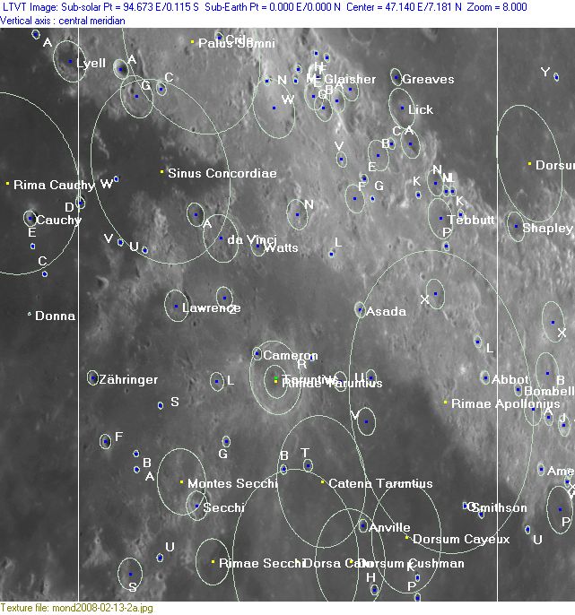
Lettered Crater Locations
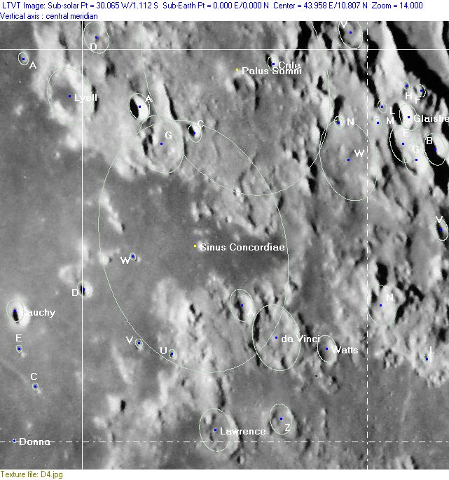
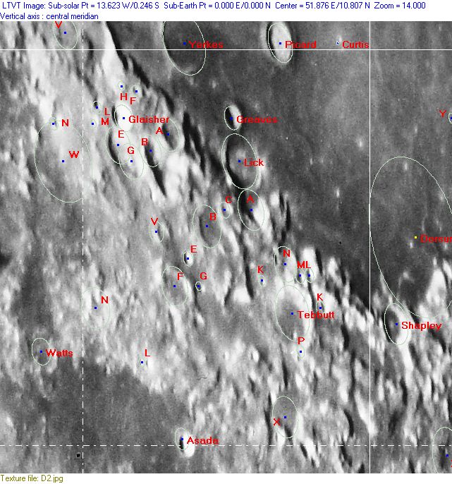
(click on the thumbnails to display full-sized images; use browser BACK button to return - the dashed white lines are the midpoints of the Rükl zones)

  Full zone with lettered craters:


  Lettered craters by quadrants:
| North West |
North East |
| South West |
South East |
Additional Information
- Other online descriptions of features in this Rükl map section:
Apollo 15's CSM Endeavour over Taruntius and Asada
- The southern part of this region was frequently photographed during most of the Apollo missions. Especially during the docking sequence of Apollo 15's Command/Service Module (Endeavour) with the Lunar Module (Falcon). Several books on manned spaceflight show mostly one of the well-known orbital photographs of the exposed SIM-bay in Apollo 15's CSM Endeavour with crater Taruntius and the moon's curved horizon in the background. One of those photographs (AS15-88-11972) shows CSM Endeavour "between" craters Taruntius (the "half" crater at the left margin) and the bright bowl-shaped crater Asada (slightly below the photograph's centre, "right" of Endeavour). Take also a look at the lower part of Apollo 15's Hasselblad Magazine 88/TT. Research: Danny Caes.
Mount Marilyn
- One of the most recognizeable surface formations which received an unofficial name by one of NASA's Apollo astronauts is the triangle-shaped "peninsula" in the lower left corner of this map. Astronaut James Lovell (Apollo 8/ Apollo 13) called it Mount Marilyn, after his wife. See also page Montes Secchi (Nomenclature).- DannyCaes DannyCaes Nov 20, 2008
- Stereo view
This page has been edited 1 times. The last modification was made by - tychocrater tychocrater on Jun 13, 2009 3:24 pm - mgx2
