Difference between revisions of "Rükl 13"
| (4 intermediate revisions by the same user not shown) | |||
| Line 64: | Line 64: | ||
<br /> | <br /> | ||
==Lettered Crater Locations== | ==Lettered Crater Locations== | ||
| − | (click on the thumbnails to display full-sized images; use browser BACK button to return - the dashed white lines are the midpoints of the Rükl zones)<br /> <br /> Full zone with [[Satellite%20feature|lettered craters]]:<br /> [http://the-moon.us/wiki/file/detail/Rukl_13_satellites.jpg [[Image:Rukl_13_satellites.jpg|external image Rukl_13_satellites.jpg | + | (click on the thumbnails to display full-sized images; use browser BACK button to return - the dashed white lines are the midpoints of the Rükl zones)<br /> <br /> Full zone with [[Satellite%20feature|lettered craters]]:<br /> [http://the-moon.us/wiki/file/detail/Rukl_13_satellites.jpg [[Image:Rukl_13_satellites.jpg|external image Rukl_13_satellites.jpg|64x64px]]]<br /> <br /> Lettered craters by quadrants:<br /> |
{| class="wiki_table" | {| class="wiki_table" | ||
| North West<br /> | | North West<br /> | ||
| Line 70: | Line 70: | ||
|- | |- | ||
| | | | ||
| − | [http://the-moon.us/wiki/file/detail/Rukl_13_satellites_NW.jpg [[Image:Rukl_13_satellites_NW.jpg|external image Rukl_13_satellites_NW.jpg | + | [http://the-moon.us/wiki/file/detail/Rukl_13_satellites_NW.jpg [[Image:Rukl_13_satellites_NW.jpg|external image Rukl_13_satellites_NW.jpg|64x64px]]]<br /> |
| | | | ||
| − | [http://the-moon.us/wiki/file/detail/Rukl_13_satellites_NE.jpg [[Image:Rukl_13_satellites_NE.jpg|external image Rukl_13_satellites_NE.jpg | + | [http://the-moon.us/wiki/file/detail/Rukl_13_satellites_NE.jpg [[Image:Rukl_13_satellites_NE.jpg|external image Rukl_13_satellites_NE.jpg|64x64px]]]<br /> |
|- | |- | ||
| | | | ||
| − | [http://the-moon.us/wiki/file/detail/Rukl_13_satellites_SW.jpg [[Image:Rukl_13_satellites_SW.jpg|external image Rukl_13_satellites_SW.jpg | + | [http://the-moon.us/wiki/file/detail/Rukl_13_satellites_SW.jpg [[Image:Rukl_13_satellites_SW.jpg|external image Rukl_13_satellites_SW.jpg|64x64px]]]<br /> |
| | | | ||
| − | [http://the-moon.us/wiki/file/detail/Rukl_13_satellites_SE.jpg [[Image:Rukl_13_satellites_SE.jpg|external image Rukl_13_satellites_SE.jpg | + | [http://the-moon.us/wiki/file/detail/Rukl_13_satellites_SE.jpg [[Image:Rukl_13_satellites_SE.jpg|external image Rukl_13_satellites_SE.jpg|64x64px]]]<br /> |
|- | |- | ||
| South West<br /> | | South West<br /> | ||
| Line 96: | Line 96: | ||
As pointed out in [http://lpod.wikispaces.com/March%2026%2C%202010 LPOD 26 March 2010], a portion of the highlands west of '''Lacus Mortis''' take on a 'pasty-looking' appearance that has yet to be explained. The two images below show the region under different lighting conditions ''(left)'' easterly-lit, ''(right)'' westerly-lit. Both images were taken from the ''[http://lroc.sese.asu.edu/index.html LROC]'' series having WAC Nos. [http://wms.lroc.asu.edu/lroc/view_lroc/LRO-L-LROC-2-EDR-V1.0/M116166990ME M116166990ME] and [http://wms.lroc.asu.edu/lroc/view_lroc/LRO-L-LROC-2-EDR-V1.0/M119694019ME M119694019ME] respectively. Each was calibrated by the [http://ltvt.wikispaces.com/Utility%20Programs#WAC_Viewer LROC_WAC_Previewer]. ''Click image for larger view.''<span class="membersnap">- | As pointed out in [http://lpod.wikispaces.com/March%2026%2C%202010 LPOD 26 March 2010], a portion of the highlands west of '''Lacus Mortis''' take on a 'pasty-looking' appearance that has yet to be explained. The two images below show the region under different lighting conditions ''(left)'' easterly-lit, ''(right)'' westerly-lit. Both images were taken from the ''[http://lroc.sese.asu.edu/index.html LROC]'' series having WAC Nos. [http://wms.lroc.asu.edu/lroc/view_lroc/LRO-L-LROC-2-EDR-V1.0/M116166990ME M116166990ME] and [http://wms.lroc.asu.edu/lroc/view_lroc/LRO-L-LROC-2-EDR-V1.0/M119694019ME M119694019ME] respectively. Each was calibrated by the [http://ltvt.wikispaces.com/Utility%20Programs#WAC_Viewer LROC_WAC_Previewer]. ''Click image for larger view.''<span class="membersnap">- | ||
{| class="captionBox" | {| class="captionBox" | ||
| − | | class="captionedImage" | | + | | class="captionedImage" | JohnMoore2 |
| − | |||
|- | |- | ||
| class="imageCaption" | JohnMoore2 | | class="imageCaption" | JohnMoore2 | ||
| Line 105: | Line 104: | ||
* {| class="captionBox" | * {| class="captionBox" | ||
| class="captionedImage" | | | class="captionedImage" | | ||
| − | [http://www.lpod.org/coppermine/displayimage.php?pid=4818&fullsize=1 [[Image: | + | [http://www.lpod.org/coppermine/displayimage.php?pid=4818&fullsize=1 [[Image:Normal_lacus-mortis-pasty.jpg|external image normal_lacus-mortis-pasty.jpg]]] |
|- | |- | ||
| class="imageCaption" | external image normal_lacus-mortis-pasty.jpg | | class="imageCaption" | external image normal_lacus-mortis-pasty.jpg | ||
Latest revision as of 18:56, 22 April 2018
Contents
Rükl Zone 13 - EUDOXUS
Neighboring maps on the Rükl Nearside Map:
| 13 |
||
Photographic Map
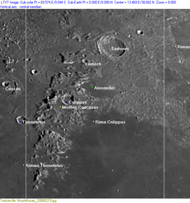
(This map is based on an Earth-based photograph that has been computer-corrected to zero libration. The vertical white lines indicate the left and right boundaries of the Rükl rectangle)

  Background image source
Named Features
- Alexander (J.Hewelcke's Mons Haemus).
- Alexander Kappa (the promontory at the northern rim of Mare Serenitatis, southeast of Alexander itself) (source: The Times Atlas of the Moon).
- Alexander Phi (the western one of the small group of hills south of Alexander Kappa) (source: The Times Atlas of the Moon).
- Annae D. Aurel. F. (Van Langren's disallowed name for the section Gamma in Montes Caucasus).
- Calippus
- Catena Mundi (J.Hewelcke's disallowed name for the northwestern border of Mare Serenitatis).
- Cusae (Van Langren's disallowed name for Eudoxus Kappa).
- Dorsum Calippus (an unofficial name from D.Caes for the wrinkle ridge near Rima Calippus at the northern part of Mare Serenitatis).
- Earhart (an unofficial name from R.Sood, L.Chappaz, and J.Melosh for a previously unknown large crater (diam. 200 km) of which the central part of it is located E.N.E. of the small bowl-shaped crater Eudoxus J, roughly speaking that's in the centre of the triangle Eudoxus - Lacus Mortis - Mare Serenitatis).
- Eudoxus (Van Langren's Copernici, J.Hewelcke's Mons Carpates).
- Glasenapp (a disallowed name from F.C.Lamech for Calippus A, southwest of Calippus itself).
- Great Pass (a well-known unofficial name for the pass between Mare Serenitatis and Mare Imbrium, or between Montes Caucasus and Montes Apenninus).
- Lamèch
- L-mountain/ L-shaped mountain (two nicknames from D.Caes for the L-shaped mountain west of Lamech) (because of its high-albedo western and southern slopes this mountain looks distinct during Full Moon, looking like an illuminated L).
- Mare Serenitatis (occupying the lower right section of Chart 13) (Van Langren's Mare Eugenianum, J.Hewelcke's Pontus Euxinus).
- Mare Serenitatis Triplet (an unofficial name from D.Caes for the curious chain of three craterlets at the upper half of Mare Serenitatis) (at 17° East/ 31°45' North).
- Mariannae Imper. F. (Van Langren's disallowed name for Calippus Alpha).
- Mons Elbruz (an unofficial name from D.Caes for the highest peak in the lunar Montes Caucasus, just west of Calippus, see also Additional Information below).
- Montes Caucasus
- Myriame (a disallowed name from F.C.Lamech for Eudoxus A, east-northeast of Eudoxus itself).
- Pasty highlands (a nickname from C.A.Wood and J.Moore for the region west of Lacus Mortis, see also Additional Information below).
- Promontorium Faraday (a disallowed name from J.F.J.Schmidt for the southern end of Montes Caucasus).
- Regio Moesia (J.Hewelcke's disallowed name for the northern border of Mare Serenitatis).
- Rima Calippus
- Shannen Ridge (an unofficial name from M.Collins, see description at the lower part of this page; Additional Information).
- Sinus Peronticus (J.Hewelcke's disallowed name for the northwestern "corner" of Mare Serenitatis).
- Sinus Sagaricus (J.Hewelcke's disallowed name for the north-northeastern part of Mare Serenitatis).
- Siredey (a disallowed name from F.C.Lamech for Cassini E (?), also called Baldet?) (E.A.Whitaker noticed this confusion).
- Terra Grandinis (Riccioli's discontinued name for the region at the upper half of Chart 13).
- Theaetetus (Riccioli's disallowed name for the 'bay' at Calippus Omega).
- (The) northwest-of-Posidonius W-ridges (a clumsy nickname from D.Caes for the two wrinkle ridges south of the northern rim of Mare Serenitatis, west of C.A.Wood's Lost Peninsula).
- Theresae Hispa. Inf. (Van Langren's disallowed name for Calippus Theta, Eta, and Omega).
- Triplet (a nickname from D.Caes for the small chain of three craterlets near the lower right corner of Chart 13, at 31°45' North/ 17° East) (this is an interesting test-object for common and large telescopes!).
- Valentine Dome (informal name, former IAU name: Linné Alpha).
- Zinger (a disallowed name from F.C.Lamech for Cassini C, northeast of Cassini itself).
Lettered Crater Locations
(click on the thumbnails to display full-sized images; use browser BACK button to return - the dashed white lines are the midpoints of the Rükl zones)

  Full zone with lettered craters:


  Lettered craters by quadrants:
| North West |
North East |
| South West |
South East |
Additional Information
- Other online descriptions of features in this Rükl map section:
Shannen Ridge
A previously undetected and officially unnamed ridge which runs from the part of the Montes Caucasus near Eudoxus toward the southern rim of Lacus Mortis (over the couple Plana and Mason) to Williams is unofficially called Shannen Ridge by Maurice Collins (with Charles Wood co-author of the 21st Century Atlas of the Moon). The name Shannen Ridge is incorporated on chart 9 of this atlas.
Mons Elbruz
As with the Mons Blanc in the lunar Alps, the lunar Caucasus range should get their own officially named peak! It would be interesting to give the peak immediately west of Calippus the name Mons Elbruz, because on earth too it's the king of the Caucasus range!
 - DannyCaes Sep 18, 2015
The pasty region west of Lacus Mortis
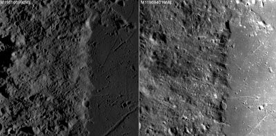
As pointed out in LPOD 26 March 2010, a portion of the highlands west of Lacus Mortis take on a 'pasty-looking' appearance that has yet to be explained. The two images below show the region under different lighting conditions (left) easterly-lit, (right) westerly-lit. Both images were taken from the LROC series having WAC Nos. M116166990ME and M119694019ME respectively. Each was calibrated by the LROC_WAC_Previewer. Click image for larger view.-
| JohnMoore2 |
| JohnMoore2 |
- {| class="captionBox"
| class="captionedImage" |
 |-
| class="imageCaption" | external image normal_lacus-mortis-pasty.jpg
|}


