Rükl 23
Contents
Rükl Zone 23 - LINNE
Neighboring maps on the Rükl Nearside Map:
| 23 |
||
Photographic Map
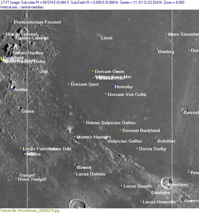
(This map is based on an Earth-based photograph that has been computer-corrected to zero libration. The vertical white lines indicate the left and right boundaries of the Rükl rectangle)

  Background image source
Named Features
- A hill northeast of Promontorium Fresnel seems to have received the Greek letter designation "Psi " (Fresnel Psi?).
- Another hill east of Promontorium Fresnel was called "Phi" (Fresnel Phi ?) (source of both Phi and Psi: System of Lunar Craters, 1966).
- Aratus CA (the strange twisted formation at Mare Serenitatis, which is called Lorca on Lunar Topographic Orthophotomap 42-A4).
- Banting
- Banting's three-fourth's ejectablanket craterlet (a weird nickname from D.Caes for a remarkable craterlet immediately southeast of Banting itself, its ejectablanket shows up as a "pacman" on orbital photographs made during high sun) (see also LROC article Nature's Art).
- Bobillier
- Bowen
- Clarae Isab. Leop. F. (Van Langren's disallowed name for the bright spot at Sulpicius Gallus M).
- Daubrée
- Donkey/ Shrek's donkey (two nicknames from A.Bozic for the dark region Manilius E and adjacent Lacus Felicitatis) (to be observed during Full Moon).
- Dorsa Sorby
- Dorsum Buckland
- Dorsum Gast
- Dorsum Owen (north of Aratus CA).
- Dorsum Von Cotta
- Great Pass (an unofficial name for the pass from Mare Serenitatis (east) to Mare Imbrium (west), between Montes Haemus-Montes Apenninus at south and Montes Caucasus at north).
- Hornsby
- Hypatiae (Van Langren's disallowed name for Sulpicius Gallus Gamma).
- Joy (see also Pit of Joy).
- Lacus Doloris
- Lacus Gaudii
- Lacus Hiemalis
- Lacus Lenitatis (east of Manilius; the pronounced crater at the lower margin of Chart 23).
- Lacus Odii
- Linné
- Manilius (Van Langren's Isabellae Reg. Hisp., J.Hewelcke's Insula Besbicus) (this is the pronounced crater at the lower margin of Chart 23).
- Manuel (at Aratus CA).
- Mare Serenitatis (Van Langren's Mare Eugenianum, J.Hewelcke's Pontus Euxinus).
- Mare Vaporum (the northeastern part of it, occupying the lower right section of Chart 23).
- Menelaus (Van Langren's Mariae Imp. Rom., J.Hewelcke's Byzantium (Urbs)).
- Menelaus Zeta (a shallow and rather large dome north-northwest of Menelaus, part of Rimae Menelaus, see Chart 24) (see also Chart 30 in the Times Atlas of the Moon).
- Montes Haemus (note about the curious orange and amber colored spots up there, see Additional Information below).
- Paludes Superiores (J.Hewelcke's disallowed name for a faint bright line at the western part of Mare Serenitatis).
- Pit of Joy (a nickname from D.Caes for the very sharp looking tiny craterlet on top of the hillock immediately east of the small crater Joy).
- Promontorium Fresnel, see Rukl's chart 22.
- Rima Sung-Mei (at Aratus CA).
- Rimae Sulpicius Gallus (once known as Fossae Sulpicius Gallus, see Lunar Topographic Orthophotomaps 41-C2, 42-D1).
- Sinus Salmydessus (J.Hewelcke's disallowed name for some sort of oblong area near or at Linne).
- Sulpicius Gallus
- Sulpicius Gallus Alpha (pronounced section of Montes Haemus, southeast of Sulpicius Gallus) (see Chart 30 in the Times Atlas of the Moon).
- Terra Nivium (Riccioli's discontinued name for the region between Montes Haemus and Montes Apenninus).
- Vallis Christel (at Aratus CA).
- Vallis Krishna (at Aratus CA).
- Yoshi (at Aratus CA).
Lettered Crater Locations
(click on the thumbnails to display full-sized images; use browser BACK button to return - the dashed white lines are the midpoints of the Rükl zones)

  Full zone with lettered craters:


  Lettered craters by quadrants:
| North West |
North East |
| South West |
South East |
Additional Information
- Other online descriptions of features in this Rükl map section:
Orange and amber colored spots at Montes Haemus
- In this region, at Montes Haemus and the small lakes west and southwest of it, the orbiting crew of Apollo 17 (december 1972) noticed lots of orange-red and amber colored spots and patches. This fact is mentioned in NASA's Apollo 17; A Preliminary Science Report. And indeed, this curious kind of coloration (at the Mts.Haemus area) is also noticeable through telescopes on Earth, especially during Full Moon (mentioned by several dedicated telescopic lunar observers). See also: Colored Regions on the Moon's Surface (Part 1). - DannyCaes Nov 11, 2008
Two partially reddish-brown colored ray craterlets north-northeast of Bowen (west-southwest of Sulpicius Gallus)
- In the summer of 1971 both of these partially reddish-brown colored ray craterlets were captured on two of Apollo 15's orbital Hasselblad photographs of the Bowen-Sulpicius Gallus region at Montes Haemus. These frames are AS15-93-12684 and 12685 (High-Resolution scans from Kipp Teague's Apollo photogalleries on Flickr).
- In December 1972 they were once again photographed from orbit during the mission of Apollo 17, also on two Hasselblad frames: AS17-152-23284 and 23285 (High-Resolution scans from Kipp Teague's Apollo photogalleries on Flickr).
- The pinpoint coordinates of these two ray craterlets are; The larger (eastern) one: LAT 18.9393/ LON 9.8642, the smaller (western) one: LAT 18.8511/ LON 9.6124. (see the LROC's online ACT-REACT QUICK MAP).
- Research: - DannyCaes Oct 11, 2015


