Rimae Liebig
Contents
[hide]Rimae Liebig
{"discontinued" IAU name)
|
Lat: 24.3°S, Long: 48.2°W, Diam: 200 km (?), Depth: , Rükl 51 |

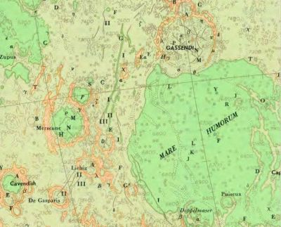
Army Map Service, 1964 An interpretation of the Liebig rilles listed in Named Lunar Formations (1935). Liebig Ir is pictured near the western shore of Mare Humorum, somewhat close to the modern Rupes Liebig. Liebig IIr and IIIr are pictured to the southwest of Liebig.
Images
LPOD Photo Gallery Lunar Orbiter Images Apollo Images
Maps
(LAC zone 93D1) LAC map Geologic map
Description
Description: Wikipedia
Additional Information
- Liebig Ir (in the nomenclature of Blagg and Müller is described in some detail in a 1965 article by William Quaide (see references). In that article, it is noted that in parts it looks like a "normal fault" (the modern Rupes Liebig), and north of that like a conventional rille (that portion currently being assigned to Rimae Mersenius).
Nomenclature
- Named after the nearby crater (Liebig).
- Mary Blagg's Collated List of 1913 included a number of rilles associated with Mersenius, Cavendish, Liebig and De Gasparis.
- Three of these rilles, catalog entries 2172, 2173, and 2185, were assigned to Liebig in Named Lunar Formations (1935). Their descriptions lean heavily of the maps and Greek-lettered designations of Neison. Unfortunately Neison's maps, and his labeling of them, is highly ambiguous.
- No rilles were associated with Liebig on the Quad Maps of the System of Lunar Craters. Liebig Ir of Named Lunar Formations appears to have become Rupes Liebig. Liebig IIr is possibly Rima De Gasparis I; the fate of Liebig IIIr is uncertain.
- The System of Lunar Craters also introduced the term rimae for describing multiple rille systems as a whole; however since no rilles were assigned to Liebig at that time, this term never really applied to Liebig Ir, IIr, and IIIr.
- Nonetheless, Rimae Liebig was listed as a "dropped" IAU name in the first editions of the IAU Planetary Gazetteer, and continues to be listed that way in the on-line version.
LPOD Articles
Bibliography
- Quaide, William. 1965. Rilles, Ridges and Domes-Clues to Maria History. Icarus, vol. 4, pp. 374-389.