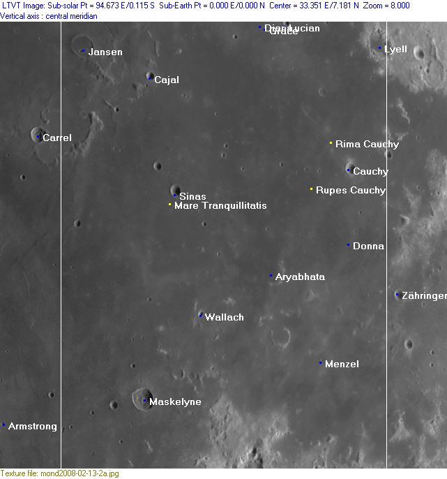
Rükl 36
Contents
[hide]Rükl Zone 36 - CAUCHY
Neighboring maps on the Rükl Nearside Map:
| 36 |
||
Photographic Map
(This map is based on an Earth-based photograph that has been computer-corrected to zero libration. The vertical white lines indicate the left and right boundaries of the Rükl rectangle)

  Background image source
Named Features
- Abduh (a disallowed name for Lyell A northwest of Lyell itself, see Lunar Topographic Orthophotomap 61-A2) (called Ring Nebula by D.Caes because of its remarkable appearance during Full Moon: a thin high-albedo ring around a tiny "star").
- Air Bubbles (a nickname from D.Caes for the couple of odd depressions at the northwestern end of Rupes Cauchy).
- Aryabhata
- Barbara Mesa (an informal NASA-related name for the pronounced peninsula east-southeast of Maskelyne, see LPOD US-1 and Other Signposts) (once called Promontorium Acutum by J.D.Cassini, Prom. Methonis by Van Langren, Prom. Heracleum by J.Hewelcke, not named by Riccioli).
- Bear Mountain (an informal NASA-related name for the elevation Maskelyne Alpha between Maskelyne A and Lonesome Mesa) (near the lower margin of Chart 36) (additional note about the name Bear Mountain: this is not the same as the one on the floor of the Taurus-Littrow Valley in which Apollo 17 landed!).
- Bob's Bend (an informal NASA-related name for the arc shaped appendix north of Barbara Mesa, see LPOD above).
- Boot Hill (an informal NASA-related name for the boot-shaped island Maskelyne Theta, south of Maskelyne, see LPOD above).
- Cajal
- Cape Bruce (an informal NASA-related name for the curious "hook" west of Maskelyne A, near the lower margin of Chart 36).
- Cape Venus (an informal NASA-related name for the small peninsula-like appendage Maskelyne Zeta near the lower right corner of Chart 36) (also called Saint Theresa?).
- Cauchy (J.Hewelcke's Insula Aea).
- Chama Peak (an informal NASA-related name for a hillock very near the lower right corner of Chart 36).
- Diamondback Rille (an informal NASA-related name for the rille between Maskelyne G and Maskelyne X).
- Diana
- Donna
- Dorsum Lamont-Maskelyne (an unofficial name from D.Caes for the wrinkle ridge running from Lamont to Maskelyne) (see also LPOD March 11, 2014) (the part of it near Maskelyne and Maskelyne B was called Snake Ridge during the hey-days of Project Apollo).
- Dorsum Sinas (an unofficial name from D.Caes for the wrinkle ridge west-southwest of Sinas).
- Duke Island (an informal NASA-related name for the hillock Maskelyne Phi slightly rightward of the lower left corner of Chart 36).
- El Greco (a disallowed name for Vitruvius G west-southwest of Lucian, see Lunar Topographic Orthophotomap 61-A1).
- Gemini Twins (an informal NASA-related name for the couple of bowl shaped craterlets west of Barbara Mesa).
- Grace
- Hussein (a disallowed name for Cauchy A north-northwest of Cauchy itself, see Lunar Topographic Orthophotomap 61-A2).
- Jansen
- Jansen Beta (the arc-shaped pronounced hill east of Carrel, south of Jansen).
- Lonesome Mesa (an informal NASA-related name for the pronounced peninsula east of Barbara Mesa).
- Lost Basin (an informal NASA-related name for the irregular crater southwest of the peninsula Cape Venus).
- Low Mesa (an informal NASA-related name for the bay-like area south-southeast of Lonesome Mesa).
- Lucian
- Lyell
- Mare Tranquillitatis (Van Langren's Mare Belgicum, J.Hewelcke's Pontus Euxinus).
- Maskelyne (Van Langren's Navei, J.Hewelcke's Insula Philyra).
- Menzel
- Mitika Peak (one of the rare names on Rand McNallys moonmap for the hillock Jansen Alpha immediately southwest of Jansen F', aka Cajal).
- Noether (a disallowed name for Cauchy D east-northeast of Cauchy itself, see Lunar Topographic Orthophotomap 61-B4).
- Rima Cauchy (once known as Fossa Cauchy, see Lunar Topographic Orthophotomap 61-A3).
- Rupes Cauchy (once known as Fossa Casals, see Lunar Topographic Orthophotomap 61-A3).
- Scopuli Erichtini (J.Hewelcke's disallowed name for the somewhat bright areas at Arago and Jansen).
- Sinas (and the curious half-disc shaped plateau at the southern part of its rim) (see also at Norman in Oceanus Procellarum).
- Sinas Skylight (an unofficial name from D.Caes for the unusual pit east-southeast of Sinas, northeast of Sinas A, see lower part of page Skylights).
- Sinus Phasianus (J.Hewelcke's disallowed name for the east-southeastern corner of Mare Tranquillitatis).
- Snake Ridge (an informal NASA-related name for the wrinkle ridge west-northwest of Maskelyne, north of Maskelyne B).
- The Cape (an informal NASA-related name for the small peninsula-like appendage Secchi Alpha near the lower right corner of Chart 36).
- Wallach
- Wash Basin (an informal NASA-related name for the bowl-shaped crater Maskelyne W, west of Boot Hill).
- Wendelini (Van Langren's disallowed name for Maskelyne A near the centre of the lower margin of Chart 36).
Lettered Crater Locations
(click on the thumbnails to display full-sized images; use browser BACK button to return - the dashed white lines are the midpoints of the Rükl zones)

  Full zone with lettered craters:


  Lettered craters by quadrants:
| North West |
North East |
| South West |
South East |
Additional Information
- Other online descriptions of features in this Rükl map section:


