Promontorium Taenarium
Contents
Promontorium Taenarium
|
Lat: 19.0°S, Long: 8.0°W, Diam: 70 km, Depth: 0.7 km, Rükl: 54 |
Table of Contents
[#Promontorium Taenarium Promontorium Taenarium]
[#Promontorium Taenarium-Images Images]
[#Promontorium Taenarium-Maps Maps]
[#Promontorium Taenarium-Description Description]
[#Promontorium Taenarium-Description: Wikipedia Description: Wikipedia]
[#Promontorium Taenarium-Additional Information Additional Information]
[#Promontorium Taenarium-Nomenclature Nomenclature]
[#Promontorium Taenarium-LPOD Articles LPOD Articles]
[#Promontorium Taenarium-Bibliography Bibliography]

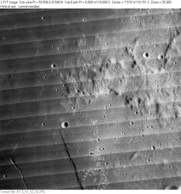
LO-IV-113H Promontorium Taenarium is the western part of the hilly peninsula sweeping across the frame from the east. The small circular craters just west of the headland are 4-km Lassell S (in the north) and 5-km Thebit D (in the south). Thebit D is at the northern end of the “Straight Wall” (Rupes Recta), visible as the dark gash running to the lower margin. The channel to its west is a part of the Rima Birt.
Images
LPOD Photo Gallery Lunar Orbiter Images Apollo Images
Maps
(LAC zone 95A1) LAC map Geologic map
Description
Description: Wikipedia
Additional Information
Depth data from Kurt Fisher database
- Viscardy, 1985: 0.7 km
Nomenclature
- Taenarium is the ancient name for the cape at the southern tip of mainland Greece, now known as Matapan or Tainaron.
- According to Whitaker (p. 208), the name Promontorium Taenarium was used by Hevelius, but for a completely different feature: the bright point at Guericke B.
- The name was apparently first associated with the modern feature by Tobias Mayer, who spelled it without the "T". Mayer's spelling was copied by Beer and Mädler, and adopted into the original IAU nomenclature by Blagg and Müller (1935).
- The spelling was corrected to its present form in Table III of the Photographic Lunar Atlas, which was approved by the IAU in 1961.
- The hilly region east of Promontorium Taenarium is called the Taenarium range on Rand Mc.Nally's moonmap and also on the same moonmap in Patrick Moore's Atlas of the Universe (1983). Research Danny Caes.
LPOD Articles
Bibliography
This page has been edited 1 times. The last modification was made by - tychocrater tychocrater on Jun 13, 2009 3:24 pm - afx3u2