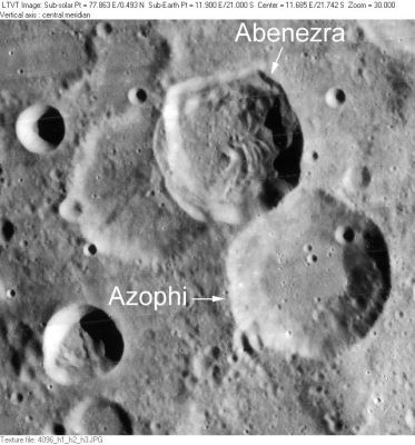
Abenezra
Contents
Abenezra
LO-IV-096H The older crater of similar size that Abenezra overlays on the southwest is Abenezra C. The field includes Azophi and a tiny part of the southwest rim of Geber is visible in the upper right corner.
Images
LPOD Photo Gallery Lunar Orbiter Images Apollo Images
- Abenezra was also captured on several frames made by the southward looking mapping/metric Fairchild camera of Apollo 16, such as frame AS16-M-0702, which shows the couple Abenezra and Azophi near the central part of the depicted curved horizon.
- Research: Danny Caes.
Maps
(LAC zone 96A4) LAC map Geologic map
Description
Elger
(IAU Directions) ABENEZRA.--When observed near the morning terminator, this noteworthy ring-plain, 27 miles in diameter, seems to be divided into two by a curved ridge which traverses the formation from N. to S., and extends beyond its limits. The irregular border rises on the E. to a height of more than 14,000 feet above the deeply-sunken floor, which includes several craters, hills, and ridges.
Wikipedia
Additional Information
- IAU page: Abenezra
- Depth data from Kurt Fisher database
- Westfall, 2000: 3.73 km
- Viscardy, 1985: 3.73 km
- Satellite craters Abenezra A and B are included in the ALPO list of banded craters
Nomenclature
- Named for Abraham ben Meir Ibn Ezra (1092-1164/1167), a Spanish mathematician and astronomer.
- This name has continued unchanged since its original usage for this feature on Riccioli's map (Whitaker, p. 210).
LPOD Articles
Bibliography
Google Scholar listings
Named Features -- Prev: Abel -- Next: Abetti
