Difference between revisions of "Rükl 57"
(Created page with "<div id="content_view" class="wiki" style="display: block"> =Rükl Zone 57 - CATHARINA= <br /> Neighboring maps on the [http://the-moon.us/wiki/R%C3%BCkl%20Index%20Map Rük...") |
|||
| Line 2: | Line 2: | ||
=Rükl Zone 57 - CATHARINA= | =Rükl Zone 57 - CATHARINA= | ||
<br /> Neighboring maps on the [http://the-moon.us/wiki/R%C3%BCkl%20Index%20Map Rükl Nearside Map]:<br /> <div id="toc"> | <br /> Neighboring maps on the [http://the-moon.us/wiki/R%C3%BCkl%20Index%20Map Rükl Nearside Map]:<br /> <div id="toc"> | ||
| − | + | ||
| − | |||
{| class="wiki_table" | {| class="wiki_table" | ||
| | | | ||
| Line 83: | Line 82: | ||
<br /> | <br /> | ||
==A lunar formation called LE ALDA (?)== | ==A lunar formation called LE ALDA (?)== | ||
| − | Mentioned during the mission of Apollo 16 in april 1972:<br /> '''154 02 57 G.E.T. - CMP Ken Mattingly''' (Command Module Pilot of CSM ''Casper''):<br /> "Okay. Maybe we could have drawn a terminator that was a little more over towards the area where we've shown our target, but there may be quite a drop-off in elevation here. It would only take - quite a bit, to the Sun angle wouldn't have to be an awful lot, on a geologic scale I guess. But the actual terminator was running down just to the west of '''Le Alda''' [or '''Mädler'''?] so I ran a strip down that".<br /> See: ''Apollo 16 Flight Journal'', David Woods and Tim Brandt.<br /> [http://history.nasa.gov/ap16fj/21_Day7.htm Day 7: Lunar Orbital Observations, Revs 35 to 45]<br /> Could that have been '''THE ALTAI''' ? (the northern extension of '''Rupes Altai''').<br /> <span class="membersnap">- | + | Mentioned during the mission of Apollo 16 in april 1972:<br /> '''154 02 57 G.E.T. - CMP Ken Mattingly''' (Command Module Pilot of CSM ''Casper''):<br /> "Okay. Maybe we could have drawn a terminator that was a little more over towards the area where we've shown our target, but there may be quite a drop-off in elevation here. It would only take - quite a bit, to the Sun angle wouldn't have to be an awful lot, on a geologic scale I guess. But the actual terminator was running down just to the west of '''Le Alda''' [or '''Mädler'''?] so I ran a strip down that".<br /> See: ''Apollo 16 Flight Journal'', David Woods and Tim Brandt.<br /> [http://history.nasa.gov/ap16fj/21_Day7.htm Day 7: Lunar Orbital Observations, Revs 35 to 45]<br /> Could that have been '''THE ALTAI''' ? (the northern extension of '''Rupes Altai''').<br /> <span class="membersnap">- DannyCaes <small>Sep 19, 2015</small></span><br /> <br /> |
==Tacitus and the high-albedo raycrater with its ''half ejectablanket'' (south of the bowl shaped crater Tacitus N)== | ==Tacitus and the high-albedo raycrater with its ''half ejectablanket'' (south of the bowl shaped crater Tacitus N)== | ||
| − | A bright "half ejectablanket" at 17°35' South/ 19°15' East (immediately south of '''Tacitus''' and the bowl shaped crater '''Tacitus N''') is noticeable during the days before, during, and after Full Moon. This ejectablanket looks like some sort of bright "arc". See also LAC 96 in B.Bussey's and P.Spudis's ''[http://the-moon.us/wiki/Clementine%20Atlas Clementine Atlas]''.<br /> <span class="membersnap">- | + | A bright "half ejectablanket" at 17°35' South/ 19°15' East (immediately south of '''Tacitus''' and the bowl shaped crater '''Tacitus N''') is noticeable during the days before, during, and after Full Moon. This ejectablanket looks like some sort of bright "arc". See also LAC 96 in B.Bussey's and P.Spudis's ''[http://the-moon.us/wiki/Clementine%20Atlas Clementine Atlas]''.<br /> <span class="membersnap">- DannyCaes <small>Nov 15, 2015</small></span><br /> |
---- | ---- | ||
| − | + | </div> | |
Revision as of 16:49, 15 April 2018
Contents
Rükl Zone 57 - CATHARINA
Neighboring maps on the Rükl Nearside Map:
| 57 |
||
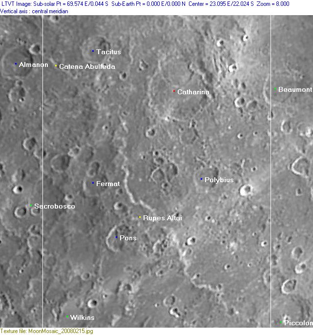
Photographic Map
(This map is based on an Earth-based photograph that has been computer-corrected to zero libration. The vertical white lines indicate the left and right boundaries of the Rükl rectangle)

  Background image source
Named Features
- A.Pavlov (a very rare case, seems to be a disallowed name for a crater southeast of Cyrillus, see A.V.Markov's book The Moon).
- Beaumont Delta (hill south of Beaumont and Beaumont M) (see Chart 85 in the Times Atlas of the Moon).
- Catena Abulfeda (see also Chart 56 for the part of it between Abulfeda and Almanon).
- Catharina (Van Langren's Piccolomini, J.Hewelcke's Mons Moschus).
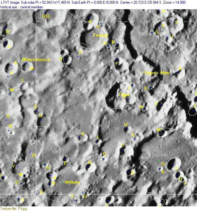
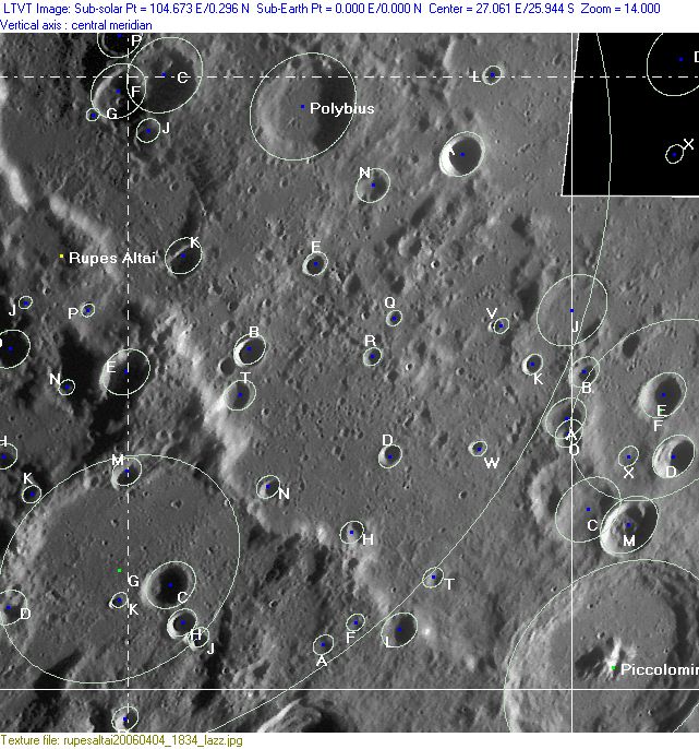
- Delvau-"X" (this is an unofficial name from R.Delvaux for a rather large X-shaped appearance at Rupes Altai) (note: Ron Delvaux's Delvau-"X" appearance is the combination of two totally different surface formations: the mountainous Rupes Altai and the bright Tycho-ray which runs all the way across Rupes Altai toward the high-albedo bowl shaped crater Polybius A) (Delvau-"X" is observable through all sorts of telescopes and large binoculars!) (ideal for First Quarter Moon observations at Public Observatories!).
- Fermat
- Gora Belukha/ Belukha mountain (an unofficial name from D.Caes for the highest peak in Rupes Altai) (because: on Earth, Gora Belukha is also the highest mountain in the Altai range).
- Larrieu's Dam (a clair-obscur effect, see page Polybius).
- Piccolomini Eta (a pronounced section of Rupes Altai west-northwest of Piccolomini) (see Chart 85 in the Times Atlas of the Moon).
- Polybius (Van Langren's Bracamonti).
- Polybius A (east of Polybius itself, this is a very bright bowl shaped crater on the eastern ray of Tycho, the one which runs all the way into Mare Nectaris) (note: on some editions of the Swiss HALLWAG moonmap, Polybius A seems to have been called Romana (a disallowed name from H.P.Wilkins), this name should have been printed near Fracastorius D on Chart 58).
- Polybius Beta (a pronounced section of Rupes Recta, south of Polybius) (see Chart 85 in the Times Atlas of the Moon).
- Pons
- Romana (a disallowed name from H.P.Wilkins for the exceptionally bright bowl shaped crater Polybius A? Or for Fracastorius D on Chart 58?).
- Rupes Altai (see also the strange case of LE ALDA, below at Additional Information).
- Tacitus (Van Langren's Chigi) (note the high-albedo ray craterlet south of it, with its half ejectablanket, see Additional Information below).
- Terra Dignitatis (Van Langren's disallowed name for the whole of Chart 57).
- Terra Fertilitatis (Riccioli's discontinued name for the southwestern part of Chart 57).
- Terra Vigoris (Riccioli's discontinued name for the northeastern part of Chart 57).
- Wilkins
An extra "name":
- The Altai boundary (on the moonmap of A.J.M.Wanders, the Altai scarp seems to be the boundary between Riccioli's Terra Fertilitatis (southwest) and Terra Vigoris (northeast), although it seems that Riccioli himself didn't created boundaries between his Terra regions).
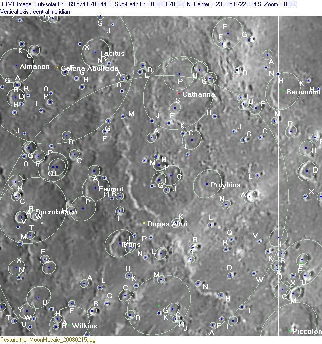
Lettered Crater Locations
(click on the thumbnails to view full-sized images; use browser BACK button to return to this page)
Full zone with lettered craters
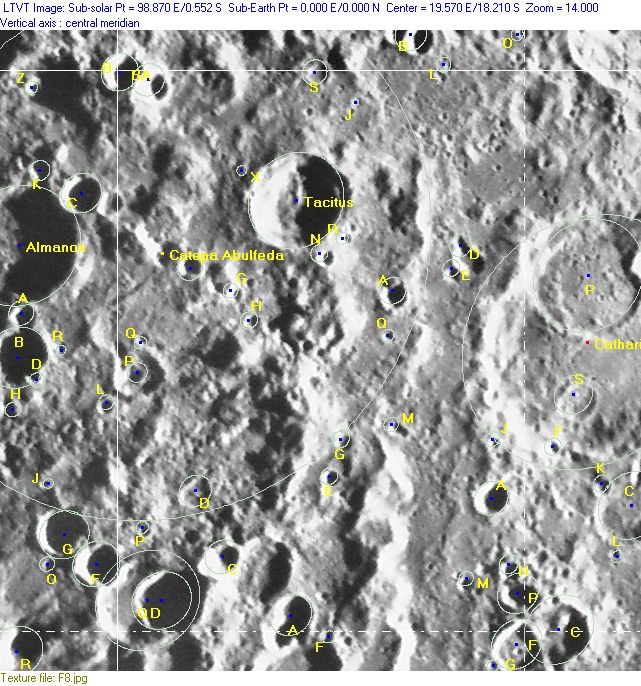
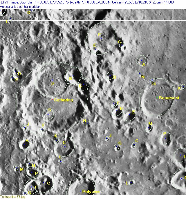
Lettered craters by quadrants
(the dashed white lines are the centerlines of the Rükl zones)
| North West |
North East |
| South West |
South East |
Additional Information
- Other online descriptions of features in this Rükl map section:
A lunar formation called LE ALDA (?)
Mentioned during the mission of Apollo 16 in april 1972:
 154 02 57 G.E.T. - CMP Ken Mattingly (Command Module Pilot of CSM Casper):
  "Okay. Maybe we could have drawn a terminator that was a little more over towards the area where we've shown our target, but there may be quite a drop-off in elevation here. It would only take - quite a bit, to the Sun angle wouldn't have to be an awful lot, on a geologic scale I guess. But the actual terminator was running down just to the west of Le Alda [or Mädler?] so I ran a strip down that".
  See: Apollo 16 Flight Journal, David Woods and Tim Brandt.
 Day 7: Lunar Orbital Observations, Revs 35 to 45
  Could that have been THE ALTAI ? (the northern extension of Rupes Altai).
 - DannyCaes Sep 19, 2015
Tacitus and the high-albedo raycrater with its half ejectablanket (south of the bowl shaped crater Tacitus N)
A bright "half ejectablanket" at 17°35' South/ 19°15' East (immediately south of Tacitus and the bowl shaped crater Tacitus N) is noticeable during the days before, during, and after Full Moon. This ejectablanket looks like some sort of bright "arc". See also LAC 96 in B.Bussey's and P.Spudis's Clementine Atlas.
 - DannyCaes Nov 15, 2015
