Difference between revisions of "Sinus Roris"
(Created page with "<div id="content_view" class="wiki" style="display: block"> =Sinus Roris= {| class="wiki_table" | Lat: 54.0°N, Long: 56.6°W, Diam: 202 km, Depth: km, [/R%C3%BCkl%201 Rü...") |
|||
| Line 3: | Line 3: | ||
{| class="wiki_table" | {| class="wiki_table" | ||
| | | | ||
| − | Lat: 54.0°N, Long: 56.6°W, Diam: 202 km, Depth: km, [ | + | Lat: 54.0°N, Long: 56.6°W, Diam: 202 km, Depth: km, [[R%C3%BCkl%201|Rükl: 1]]<br /> |
|} | |} | ||
<div id="toc"> | <div id="toc"> | ||
=Table of Contents= | =Table of Contents= | ||
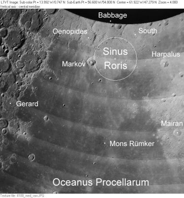
| − | <div style="margin-left: 1em">[#Sinus Roris Sinus Roris]</div><div style="margin-left: 2em">[#Sinus Roris-Images Images]</div><div style="margin-left: 2em">[#Sinus Roris-Maps Maps]</div><div style="margin-left: 2em">[#Sinus Roris-Description Description]</div><div style="margin-left: 2em">[#Sinus Roris-Description: Neison, 1876 Description: Neison, 1876]</div><div style="margin-left: 2em">[#Sinus Roris-Description: Wikipedia Description: Wikipedia]</div><div style="margin-left: 2em">[#Sinus Roris-Additional Information Additional Information]</div><div style="margin-left: 2em">[#Sinus Roris-Nomenclature Nomenclature]</div><div style="margin-left: 2em">[#Sinus Roris-LPOD Articles LPOD Articles]</div><div style="margin-left: 2em">[#Sinus Roris-Bibliography Bibliography]</div></div>[http://www.lpod.org/coppermine/displayimage.php?pid=3206&fullsize=1 [[Image:normal_Sinus_Roris_LO-IV-188M_LTVT.JPG|external image normal_Sinus_Roris_LO-IV-188M_LTVT.JPG]]]<br /> ''[http://lpod.org/coppermine/displayimage.php?pos=-3206 LO-IV-188M]'' The white circle illustrates the current [ | + | <div style="margin-left: 1em">[#Sinus Roris Sinus Roris]</div><div style="margin-left: 2em">[#Sinus Roris-Images Images]</div><div style="margin-left: 2em">[#Sinus Roris-Maps Maps]</div><div style="margin-left: 2em">[#Sinus Roris-Description Description]</div><div style="margin-left: 2em">[#Sinus Roris-Description: Neison, 1876 Description: Neison, 1876]</div><div style="margin-left: 2em">[#Sinus Roris-Description: Wikipedia Description: Wikipedia]</div><div style="margin-left: 2em">[#Sinus Roris-Additional Information Additional Information]</div><div style="margin-left: 2em">[#Sinus Roris-Nomenclature Nomenclature]</div><div style="margin-left: 2em">[#Sinus Roris-LPOD Articles LPOD Articles]</div><div style="margin-left: 2em">[#Sinus Roris-Bibliography Bibliography]</div></div>[http://www.lpod.org/coppermine/displayimage.php?pid=3206&fullsize=1 [[Image:normal_Sinus_Roris_LO-IV-188M_LTVT.JPG|external image normal_Sinus_Roris_LO-IV-188M_LTVT.JPG]]]<br /> ''[http://lpod.org/coppermine/displayimage.php?pos=-3206 LO-IV-188M]'' The white circle illustrates the current [[IAU|IAU]] definition of '''Sinus Roris'''. Originally the name seems to have meant most of [[Oceanus%20Procellarum|Oceanus Procellarum]] north of [[Mons%20R%C3%BCmker|Mons Rümker]], but ending at [[Harpalus|Harpalus]], for the dark [[mare|mare]] region beyond that (upper right) is now regarded as part of [[Mare%20Frigoris|Mare Frigoris]].<br /> <br /> |
==Images== | ==Images== | ||
[http://www.lpod.org/coppermine/thumbnails.php?album=search&type=full&search=Sinus%20Roris LPOD Photo Gallery] [http://www.lpi.usra.edu/resources/lunar_orbiter/bin/srch_nam.shtml?Sinus%20Roris%7C0 Lunar Orbiter Images]<br /> | [http://www.lpod.org/coppermine/thumbnails.php?album=search&type=full&search=Sinus%20Roris LPOD Photo Gallery] [http://www.lpi.usra.edu/resources/lunar_orbiter/bin/srch_nam.shtml?Sinus%20Roris%7C0 Lunar Orbiter Images]<br /> | ||
| Line 14: | Line 14: | ||
<br /> | <br /> | ||
==Maps== | ==Maps== | ||
| − | ''([ | + | ''([[LAC%20zone|LAC zone]] 10C2)'' [http://planetarynames.wr.usgs.gov/images/Lunar/lac_10.pdf USGS Digital Atlas PDF]<br /> <br /> |
==Description== | ==Description== | ||
<br /> | <br /> | ||
| − | ==Description: [ | + | ==Description: [[Neison%2C%201876|Neison, 1876]]== |
| − | ''([ | + | ''([[IAU%20Directions|IAU Directions]])'' SINUS RORIS - The great northern bay of the [[Oceanus%20Procellarum|Oceanus Procellarum]], bordered on the east by the highlands of the [[Sinus%20Iridum|Sinus Iridum]], on the north by the elevated region between [[Harpalus|Harpalus]] and [[Oenopides|Oenopides]], and on the west by the bright ridge extending between [[Oenopides|Oenopides]] and [[Gerard|Gerard]]. The northern section of the floor is the brightest and is traversed by a number of grey ridges.<br /> <br /> |
==Description: Wikipedia== | ==Description: Wikipedia== | ||
[http://en.wikipedia.org/wiki/Sinus_Roris Sinus Roris]<br /> <br /> | [http://en.wikipedia.org/wiki/Sinus_Roris Sinus Roris]<br /> <br /> | ||
| Line 26: | Line 26: | ||
* '''Sinus Roris''' is Latin for "Bay of Dew". | * '''Sinus Roris''' is Latin for "Bay of Dew". | ||
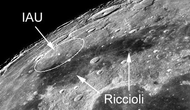
| − | * According to [ | + | * According to [[Whitaker|Whitaker]] (p. 216), this name was introduced on [[Riccioli|Riccioli]]'s map. However, Riccioli used the name to refer to the dark mare patches on either side of the crater [[Harpalus|Harpalus]] as seen in this zero-libration Earth-based view adapted from the ''[[Consolidated%20Lunar%20Atlas|Consolidated Lunar Atlas]]'' (note: for orientation, the word "Riccioli" is printed over [[Sinus%20Iridum|Sinus Iridum]] and the prominent central-peaked crater at the top is [[Pythagoras|Pythagoras]] with [[Babbage|Babbage]] below it): |
[http://lpod.org/coppermine/displayimage.php?pos=-3207 [[Image:Sinus_Roris_per_Riccioli_and_IAU_CLA-A16_LTVT.JPG|external image Sinus_Roris_per_Riccioli_and_IAU_CLA-A16_LTVT.JPG]]]<br /> | [http://lpod.org/coppermine/displayimage.php?pos=-3207 [[Image:Sinus_Roris_per_Riccioli_and_IAU_CLA-A16_LTVT.JPG|external image Sinus_Roris_per_Riccioli_and_IAU_CLA-A16_LTVT.JPG]]]<br /> | ||
| − | * Later cartographers extended Riccioli's definition of [ | + | * Later cartographers extended Riccioli's definition of [[Mare%20Frigoris|Mare Frigoris]] to include the dark mare region on the east of [[Harpalus|Harpalus]]. This pushed '''Sinus Roris''' to the west and south, where it assumed an increasingly ill-defined status. |
| − | * The name as adopted into the original [ | + | * The name as adopted into the original [[IAU%20nomenclature|IAU nomenclature]] of [[Blagg%20and%20M%C3%BCller|Blagg and Müller]] (1935), presumably refers to the large area described by Neison (above), which incorporates most of [[Oceanus%20Procellarum|Oceanus Procellarum]] north of [[Mons%20R%C3%BCmker|Mons Rümker]]. |
| − | * The name as printed on the ''[ | + | * The name as printed on the ''[[System%20of%20Lunar%20Craters|System of Lunar Craters]]'' [[Quad%20Maps|Quad Maps]] seems to continue this tradition, with the name printed in [[Oceanus%20Procellarum|Oceanus Procellarum]] roughly midway between [[Markov|Markov]] and [[Mairan|Mairan]]. |
| − | * For unknown reasons the [ | + | * For unknown reasons the [[IAU%20Planetary%20Gazetteer|IAU Planetary Gazetteer]] adopted a position and diameter (quoted in the title line of this page) that correspond to a much more restricted area, which is now, by default, the official definition. On the highland side it is bounded roughly by the craters [[Markov|Markov]], [[Oenopides|Oenopides]], [[Babbage|Babbage]] and [[South|South]]; and on the mare side it extends only to about the location of '''[[Harpalus|Harpalus]] E'''. Most of the area within this official circle is rough bright material, rather than dark mare. |
<br /> | <br /> | ||
==LPOD Articles== | ==LPOD Articles== | ||
Revision as of 15:17, 15 April 2018
Contents
Sinus Roris
|
Lat: 54.0°N, Long: 56.6°W, Diam: 202 km, Depth: km, Rükl: 1 |
Table of Contents
[#Sinus Roris Sinus Roris]
[#Sinus Roris-Images Images]
[#Sinus Roris-Maps Maps]
[#Sinus Roris-Description Description]
[#Sinus Roris-Description: Neison, 1876 Description: Neison, 1876]
[#Sinus Roris-Description: Wikipedia Description: Wikipedia]
[#Sinus Roris-Additional Information Additional Information]
[#Sinus Roris-Nomenclature Nomenclature]
[#Sinus Roris-LPOD Articles LPOD Articles]
[#Sinus Roris-Bibliography Bibliography]

LO-IV-188M The white circle illustrates the current IAU definition of Sinus Roris. Originally the name seems to have meant most of Oceanus Procellarum north of Mons Rümker, but ending at Harpalus, for the dark mare region beyond that (upper right) is now regarded as part of Mare Frigoris.
Images
LPOD Photo Gallery Lunar Orbiter Images
- Although there's nothing Sinus Roris-like mentioned in the LPI's Apollo Images Search, there are few orbital Hasselblads of Sinus Roris' southern part in Apollo 15's Hasselblad magazine 93-P (photographs AS15-93-12730 to 12734, looking north). Research: Danny Caes
- Curious twisted arc-shapes in Sinus Roris. Take a look at the lower part of Lunar Orbiter 4's frame LOIV-170-H3. This kind of twisted arc-shapes is also noticeable at Mare Frigoris, between La Condamine and J.Herschel. - DannyCaes DannyCaes Nov 10, 2009
Maps
(LAC zone 10C2) USGS Digital Atlas PDF
Description
Description: Neison, 1876
(IAU Directions) SINUS RORIS - The great northern bay of the Oceanus Procellarum, bordered on the east by the highlands of the Sinus Iridum, on the north by the elevated region between Harpalus and Oenopides, and on the west by the bright ridge extending between Oenopides and Gerard. The northern section of the floor is the brightest and is traversed by a number of grey ridges.
Description: Wikipedia
Additional Information
Nomenclature
- Sinus Roris is Latin for "Bay of Dew".
- According to Whitaker (p. 216), this name was introduced on Riccioli's map. However, Riccioli used the name to refer to the dark mare patches on either side of the crater Harpalus as seen in this zero-libration Earth-based view adapted from the Consolidated Lunar Atlas (note: for orientation, the word "Riccioli" is printed over Sinus Iridum and the prominent central-peaked crater at the top is Pythagoras with Babbage below it):
- Later cartographers extended Riccioli's definition of Mare Frigoris to include the dark mare region on the east of Harpalus. This pushed Sinus Roris to the west and south, where it assumed an increasingly ill-defined status.
- The name as adopted into the original IAU nomenclature of Blagg and Müller (1935), presumably refers to the large area described by Neison (above), which incorporates most of Oceanus Procellarum north of Mons Rümker.
- The name as printed on the System of Lunar Craters Quad Maps seems to continue this tradition, with the name printed in Oceanus Procellarum roughly midway between Markov and Mairan.
- For unknown reasons the IAU Planetary Gazetteer adopted a position and diameter (quoted in the title line of this page) that correspond to a much more restricted area, which is now, by default, the official definition. On the highland side it is bounded roughly by the craters Markov, Oenopides, Babbage and South; and on the mare side it extends only to about the location of Harpalus E. Most of the area within this official circle is rough bright material, rather than dark mare.
LPOD Articles
Bibliography
This page has been edited 1 times. The last modification was made by - tychocrater tychocrater on Jun 13, 2009 3:24 pm - afx3u2
