Difference between revisions of "Lamont"
| Line 4: | Line 4: | ||
| Lat: 4.4°N, Long: 23.7°E, Diam: 106 km, Depth: km, Rükl: 35<br /> | | Lat: 4.4°N, Long: 23.7°E, Diam: 106 km, Depth: km, Rükl: 35<br /> | ||
|} | |} | ||
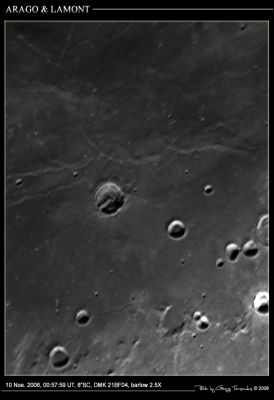
| − | [http://www.lpod.org/coppermine/displayimage.php?pid=1042&fullsize=1 [[Image:Normal_061110_Arago+Lamont_Tar.jpg|external image normal_061110_Arago+Lamont_Tar.jpg]]][http://www.mapaplanet.org/explorer-bin/explorer.cgi?map=Moon&layers=moon_clementine_ratio&info=NO&advoption=YES&lines=400&samples=400&sizeSelector=resolution&Resolution=40&projection=MERC&grid=none&stretch=auto&north=9.3&south=-0.5&west=18.7&east=28.7¢er=23.7&defaultcenter=on¢er_lat=0 [[Image: | + | [http://www.lpod.org/coppermine/displayimage.php?pid=1042&fullsize=1 [[Image:Normal_061110_Arago+Lamont_Tar.jpg|external image normal_061110_Arago+Lamont_Tar.jpg]]][http://www.mapaplanet.org/explorer-bin/explorer.cgi?map=Moon&layers=moon_clementine_ratio&info=NO&advoption=YES&lines=400&samples=400&sizeSelector=resolution&Resolution=40&projection=MERC&grid=none&stretch=auto&north=9.3&south=-0.5&west=18.7&east=28.7¢er=23.7&defaultcenter=on¢er_lat=0 [[Image:Lamont.t.jpg|external image jpg&height=300&width=300&bbox=18.7,-0.5,28.7,9.3&resamp_method=nearest_neighbor]]]<br /> '''Left''': ''[http://lpod.org/coppermine/displayimage.php?pos=-1042 George Tarsoudis]'' (north to left): The prominent crater to the left of center is [[Arago|Arago]]. '''Lamont''' is above it.<br /> '''Right''': ''Clementine UV/VIS Ratio Map'' (north at top): Mercator projection dynamically created by USGS lunar [http://www.mapaplanet.org/explorer/help/wmsUserDoc.html Web Map Service]. Click [http://planetarynames.wr.usgs.gov/jsp/AdvanceSearch2.jsp?body=Moon&ft=ALL&nlat=9.3&slat=-0.5&wlon=18.7&elon=28.7&lonDirection=EAST&as=ANY&sort=AName&ShowType=Yes&ShowDiam=Yes&ShowLat=Yes&ShowLon=Yes&ShowAD=Yes here] for a USGS-generated list of all [[IAU|IAU]]-named features with centers in the current field.<br /> <div id="toc"> |
==Images== | ==Images== | ||
Latest revision as of 19:06, 18 April 2018
Contents
Lamont (aka Dorsa Lamont)
| Lat: 4.4°N, Long: 23.7°E, Diam: 106 km, Depth: km, Rükl: 35 |


Left: George Tarsoudis (north to left): The prominent crater to the left of center is Arago. Lamont is above it.
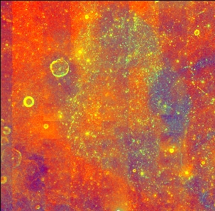
Right: Clementine UV/VIS Ratio Map (north at top): Mercator projection dynamically created by USGS lunar Web Map Service. Click here for a USGS-generated list of all IAU-named features with centers in the current field.
Images
LPOD Photo Gallery Lunar Orbiter Images Apollo Images
- A number of Ranger 8's Camera A frames show the southern part of the Lamont wrinkle ridge system. Frame A044 is one of them.
- Apollo 11's AS11-37-5438 is one of the most unusual and most remarkable orbital Hasselblads of Lamont, made during local sunrise (morning terminator) -- see A Lost Gem LPOD. Lamont is the system of wrinkle ridges at left of the photograph's centre. Carrel (formerly Jansen B) is the crater near the photograph's upper left corner. By the way, I wonder if the photographed region (Lamont and Carrel on AS11-37-5438) was ever confirmed by others. Anyway, I did!
- Research Ranger 8 and Apollo 11 photography: Danny Caes
Maps
(LAC zone 60C1) LAC map Geologic map LM map AIC map
Description
Lamont is a peculiar concentration of concentric and radial ridges in southwestern Mare Tranquillitatis. The Clementine image shows one of its oddities. Although its center is red (in false color images) like most of Tranquillitatis, Lamont is circled by a blue lava well seen in the Apollo image mentioned above (note that these colors may be reversed from those in other Clementine ratio images). The ridges around Lamont are thought to mark the location of a buried ancient impact basin, about the size of Grimaldi, which reveals itself as an anomalous concentration of mass ("mascon") in gravity maps.
Description: Wikipedia
Additional Information
The more-or-less circle shaped central part of the wrinkle ridge system which is officially known as Lamont contains a unique ring-shaped abundance of Irregular Mare Patches (IMPs). Research: John Moore.
  See lower part of the page Ghost Craters.
Nomenclature
- Named for Johann von Lamont (December 13, 1805 - August 6, 1879), a Scottish-born German astronomer and physicist. His most important work was on the magnetism of the Earth. He discovered a magnetic decennial period (ten-year cycle) and the electric current in the Earth closing the electric "circuit" creating the magnetic field in 1850. This roughly matched the eleven-year sunspot cycle discovered by Heinrich Schwabe. He calculated the orbits of the moons of Uranus and Saturn, obtaining the first value for Uranus' mass. By chance he observed Neptune in 1845 and twice in 1846, but did not recognize the object as being a new planet.
- According to Mary Blagg's Collated List this feature (Cat. No. 539) was known as Arago M to Schmidt, but was not named (or perhaps even recognized?) by her other two authorities.
- According to Whitaker (p. 226), the name Lamont (under which it was introduced into the original IAU nomenclature) was introduced by Krieger and König.
- Because this is a system of wrinkle ridges, it should be re-named Dorsa Lamont. - DannyCaes Oct 14, 2015
- Lamont's IMP-rich ghost crater. This is a new "name" from D.Caes, thanks to the interesting research of John Moore, for the remarkable ring within Lamont which shows an abundance of mysterious Irregular Mare Patches (IMPs). Thanks John! - DannyCaes Jul 2, 2017
LPOD Articles
How can you be tranquil Something for everyone Going Extreme A Lost Gem
Lunar 100
L53: Possible buried basin.
Bibliography
Wood, C.A. Jan. 2000. Lamont: A Buried Mystery. S&T Jan 2000 v99 p134