Difference between revisions of "Mons Gruithuisen Delta"
| Line 7: | Line 7: | ||
|} | |} | ||
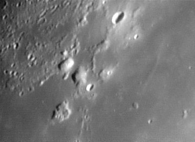
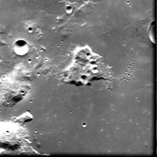
[http://www.lpod.org/coppermine/albums/userpics/zGruithuisen051015jp.jpg [[Image:normal_zGruithuisen051015jp.jpg|external image normal_zGruithuisen051015jp.jpg]]][http://esamultimedia.esa.int/images/smart_1/AMI_EAE3_001775_00019_00020_H.JPG [[Image:AMI_EAE3_001775_00019_00020_H.JPG|external image AMI_EAE3_001775_00019_00020_H.JPG]]]<br /> '''Left''': ''[http://lpod.org/coppermine/displayimage.php?pos=-1998 Howard Eskildsen]'' The 16-km diameter crater at the top of this north-up Earth-based image is '''[[Mairan|Mairan]] A'''. Following the ridge south from this one encounters two prominent blister-like peaks. The one on the left (in brighter sunlight) is [[Mons%20Gruithuisen%20Gamma|Mons Gruithuisen Gamma]]. '''Mons Gruithuisen Delta''' is to its right, and to the right of that, the 9-km crater '''[[Gruithuisen|Gruithuisen]] B'''. The more scab-like hill to the south of these, once known as '''[[Gruithuisen|Gruithuisen]] Zeta''', is no longer named.<br /> '''Right''': ''[http://esamultimedia.esa.int/images/smart_1/AMI_EAE3_001775_00019_00020_H.JPG SMART-1]'' This space-based view, with north roughly to the left, appears to have been taken from over '''[[Gruithuisen|Gruithuisen]] Zeta''' (the scab-like hill). [[Mons%20Gruithuisen%20Gamma|Mons Gruithuisen Gamma]] is partially visible in the lower left corner with '''Mons Gruithuisen Delta''' and '''[[Gruithuisen|Gruithuisen]] B''' above it. The northern rim of 15-km diameter [[Gruithuisen|Gruithuisen]] is visible near the top of the right margin.<br /> <br /> <div id="toc"> | [http://www.lpod.org/coppermine/albums/userpics/zGruithuisen051015jp.jpg [[Image:normal_zGruithuisen051015jp.jpg|external image normal_zGruithuisen051015jp.jpg]]][http://esamultimedia.esa.int/images/smart_1/AMI_EAE3_001775_00019_00020_H.JPG [[Image:AMI_EAE3_001775_00019_00020_H.JPG|external image AMI_EAE3_001775_00019_00020_H.JPG]]]<br /> '''Left''': ''[http://lpod.org/coppermine/displayimage.php?pos=-1998 Howard Eskildsen]'' The 16-km diameter crater at the top of this north-up Earth-based image is '''[[Mairan|Mairan]] A'''. Following the ridge south from this one encounters two prominent blister-like peaks. The one on the left (in brighter sunlight) is [[Mons%20Gruithuisen%20Gamma|Mons Gruithuisen Gamma]]. '''Mons Gruithuisen Delta''' is to its right, and to the right of that, the 9-km crater '''[[Gruithuisen|Gruithuisen]] B'''. The more scab-like hill to the south of these, once known as '''[[Gruithuisen|Gruithuisen]] Zeta''', is no longer named.<br /> '''Right''': ''[http://esamultimedia.esa.int/images/smart_1/AMI_EAE3_001775_00019_00020_H.JPG SMART-1]'' This space-based view, with north roughly to the left, appears to have been taken from over '''[[Gruithuisen|Gruithuisen]] Zeta''' (the scab-like hill). [[Mons%20Gruithuisen%20Gamma|Mons Gruithuisen Gamma]] is partially visible in the lower left corner with '''Mons Gruithuisen Delta''' and '''[[Gruithuisen|Gruithuisen]] B''' above it. The northern rim of 15-km diameter [[Gruithuisen|Gruithuisen]] is visible near the top of the right margin.<br /> <br /> <div id="toc"> | ||
| − | + | ||
| − | |||
==Images== | ==Images== | ||
| − | [http://www.lpod.org/coppermine/thumbnails.php?album=search&type=full&search=Mons%20Gruithuisen%20Delta LPOD Photo Gallery] [http://www.lpi.usra.edu/resources/lunar_orbiter/bin/srch_nam.shtml?Mons%20Gruithuisen%20Delta%7C0 Lunar Orbiter Images] [http://www.lpi.usra.edu/resources/apollo/search/feature/?feature=Mons%20Gruithuisen%20Delta Apollo Images]<br /> Lunar Orbiter 5's [http://www.lpi.usra.edu/resources/lunarorbiter/frame/?5183 Frame 183] shows both '''Gruithuisen Gamma''' and '''Delta''', and also the chain of teardrop-shaped craterlets near the concentric crater '''Gruithuisen K''' (near the photograph's upper left corner).<span class="membersnap">- | + | [http://www.lpod.org/coppermine/thumbnails.php?album=search&type=full&search=Mons%20Gruithuisen%20Delta LPOD Photo Gallery] [http://www.lpi.usra.edu/resources/lunar_orbiter/bin/srch_nam.shtml?Mons%20Gruithuisen%20Delta%7C0 Lunar Orbiter Images] [http://www.lpi.usra.edu/resources/apollo/search/feature/?feature=Mons%20Gruithuisen%20Delta Apollo Images]<br /> Lunar Orbiter 5's [http://www.lpi.usra.edu/resources/lunarorbiter/frame/?5183 Frame 183] shows both '''Gruithuisen Gamma''' and '''Delta''', and also the chain of teardrop-shaped craterlets near the concentric crater '''Gruithuisen K''' (near the photograph's upper left corner).<span class="membersnap">- DannyCaes <small>Mar 23, 2008</small></span><br /> <br /> |
==Maps== | ==Maps== | ||
''([[LAC%20zone|LAC zone]] 23C3)'' [http://www.lpi.usra.edu/resources/mapcatalog/LAC/lac23/ LAC map] [http://www.lpi.usra.edu/resources/mapcatalog/usgs/I805/ Geologic map]<br /> <br /> | ''([[LAC%20zone|LAC zone]] 23C3)'' [http://www.lpi.usra.edu/resources/mapcatalog/LAC/lac23/ LAC map] [http://www.lpi.usra.edu/resources/mapcatalog/usgs/I805/ Geologic map]<br /> <br /> | ||
| Line 41: | Line 40: | ||
<br /> | <br /> | ||
---- | ---- | ||
| − | + | </div> | |
Revision as of 16:38, 15 April 2018
Contents
Mons Gruithuisen Delta
(current IAU name; former IAU name: Gruithuisen Delta)
|
Lat: 36.0°N, Long: 39.5°W, Diam: 20 km, Height: km, Rükl: 9 |


Left: Howard Eskildsen The 16-km diameter crater at the top of this north-up Earth-based image is Mairan A. Following the ridge south from this one encounters two prominent blister-like peaks. The one on the left (in brighter sunlight) is Mons Gruithuisen Gamma. Mons Gruithuisen Delta is to its right, and to the right of that, the 9-km crater Gruithuisen B. The more scab-like hill to the south of these, once known as Gruithuisen Zeta, is no longer named.
Right: SMART-1 This space-based view, with north roughly to the left, appears to have been taken from over Gruithuisen Zeta (the scab-like hill). Mons Gruithuisen Gamma is partially visible in the lower left corner with Mons Gruithuisen Delta and Gruithuisen B above it. The northern rim of 15-km diameter Gruithuisen is visible near the top of the right margin.
Images
LPOD Photo Gallery Lunar Orbiter Images Apollo Images
Lunar Orbiter 5's Frame 183 shows both Gruithuisen Gamma and Delta, and also the chain of teardrop-shaped craterlets near the concentric crater Gruithuisen K (near the photograph's upper left corner).- DannyCaes Mar 23, 2008
Maps
(LAC zone 23C3) LAC map Geologic map
Description
Diviner IR data identifies this as one of the most silica-rich volcanic regions of the Moon. (Glotch et al, , 2010).
Description: Elger
(IAU Directions) GRUITHUISEN DELTA AND GAMMA.--On the N. of this bright crater, in N. lat. 36 deg., W. long. 40 deg., rises a fine mountain, delta, nearly 6,000 feet in height, and on the N.W. of it the larger mass gamma, almost as lofty.
Description: Wikipedia
Additional Information
- Age estimate of 3.85 to 3.7 billion years based on crater counts (Wagner et al, 2002, Stratigraphic sequence and ages of volcanic units in the Gruithuisen region of the Moon. J. Geophys. Res. 107, E11, 5104 ).
- Unexplored Areas of the Moon: Nonmare Domes A White Paper submitted to the Planetary Science Decadal Survey 2013-2022 - astrokat astrokat Aug 8, 2010
- Primary Author: Sarah E. Braden
- School of Earth and Space Exploration, Arizona State University
Nomenclature
- Named from nearby crater. (Gruithuisen)
- In the original IAU Nomenclature of Named Lunar Formations this feature was known as Gruithuisen Delta. Although all such Greek-lettered names were discontinued in IAU Transactions XVB (1973), this name was restored (with the addition of the Latinized "Mons" prefix) in IAU Transactions XVIB (1976).
- In his informal 1953 tour of Mare Imbrium, Leland Copeland referred to the Gruithuisen domes as the Three Rocks. D.Caes research.
LPOD Articles
Lunar 100
L49: Volcanic domes formed with viscous lavas.
Bibliography
- Glotch, T.D. and others (2010) Highly Silicic Compositions on the Moon. Science 329 no. 5998 pp. 1510-1513.
- Harold Hill. A Portfolio of Lunar Drawings, pages 90, 91.