South Pole - Aitken Basin
Contents
South Pole - Aitken Basin
(unofficial name)
| Lat: 56°S, Long: 180°E, Main ring diam: 2500 km, Depth: 8.5-12 km, Rukl: farside |

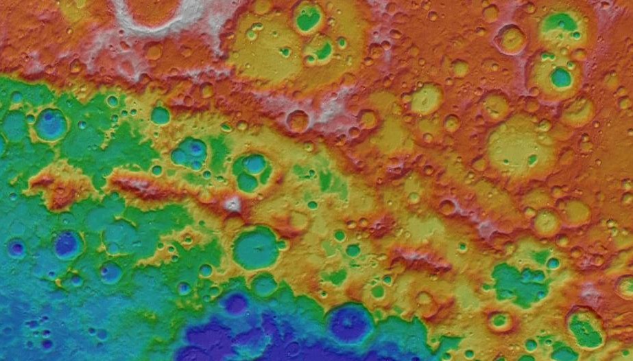
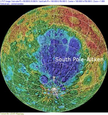
left: Clementine Altimeter Data (plotted on shaded relief background) . right: LROC .North east rim of SPA basin, where double ring structure is best preserved.
Images
LPOD Photo Gallery Lunar Orbiter Images
- The South Pole-Aitken Basin shows up very nicely in a recent JAXA/Kaguya topography image map. See LPOD link below. - JohnMoore2
Maps
(LAC zone 132C1) USGS Digital Atlas PDF LRO LOLA Topo Map (See 4.09.2010)
Basin Classification
(description of terms and most numeric basin data from Wood, C.A. (2004) Impact Basin Database)
| Certainty of Existence |
USGS Age |
Wilhelms Age Group |
Ring Diameters |
Mare Thickness |
Mascon |
| Certain |
pre-Nectarian |
1 |
2000, 2500 km |
Description
According to Wilhelms (1987, p. 145), Hartmann and Kuiper were the first to speculate that the Moon's south polar mountains might form the ring of a farside basin, but their prediction was forgotten until several investigators came to a similar conclusion while reviewing spacecraft imagery in the 1970's. In a recent review, Spudis et al. (2008), citing Wilhelms as their authority, say the SPA is "the largest and oldest impact feature on the Moon." Wilhelms actually says that although many older impacts must have been obliterated, he was able to locate 30 pre-Nectarian basins of uncertain age, and specifically assigned a slightly older age (p. 278) and considerably larger diameter (p. 245) to the Procellarum Basin. Wilhelms (Fig. 1.9) identified peaks between Casatus and Drygalski, as well as those near Cabeus as SPA massifs. He also thinks certain peaks photographed by Apollo 8 near the center of the Moon's farside are part of SPA rings (Fig. 8.9). Spudis et al. (2008) quote a diameter of "over 2600 km" from Spudis et al. (1994) and identify Leibnitz Beta as one of the most prominent peaks on the outer rim, rising 8 km above the "interior shelf" of the basin, and Shackleton as lying on a smaller peak on an inner ring some 3.5 to 4 km lower than the outer one. How these identifications were made is not clearly explained, and the fact that Leibnitz Beta is 185 km from Shackleton is somewhat difficult to reconcile with claims that the SPA rings are separated by 250-300 km in radius.. - JimMosher
Additional Information
- Mare area of 190,725 km^2 according to measurements by Jim Whitford-Stark.
- When there's favourable libration at the moon's southern limb, it is sometimes possible to observe subtle traces of the most southern boundaries of the Southpole-Aitken Basin (at the near side of the moon's south polar regions). There's some sort of parallel arrangement running over the cratered surface.- DannyCaes Feb 8, 2009 See also: Montes Leibnitz
- A recent article by Pugacheva et al. deduces from mineralogical analysis a ring structure rather different from that of earlier reports. The south polar peaks are identified as part of a 3500 km outer ring that includes the craters Tsiolkovskiy and Chebyshev within its perimeter. Aitken is on a ~1940 km diameter, slightly elliptical inner ring which falls just short of including Schrödinger and Zeeman near the south pole. Inside this are two additional rings with diameters of 1280 and 420 km. The latter of these is centered on the deepest part of the basin. The other rings are systematically shifted in position, the outermost ring having its center 730 km from the center of the innermost ring.
- ASU Image of the Week.
- ArcGIS tool (a somewhat similar tool as used for the Act-React Quickmap) for evaluating proposed landing site within the South Pole Aitken (SPA) basin. Scroll down in this linked page, and click on each thumbnail image for an interactive, zoomable experience. Future updates in base maps and feature layers are forecast as the tool matures.
Nomenclature
- The name is derived from the convention of naming certain basins using the names of features at opposite ends of a diameter. In this case, a north-south line through the basin roughly span's the distance from the Moon's South Pole to the crater Aitken.
LPOD Articles
- The Best Farside Map of the Moon (by Kaguya).
Bibliography
- Nakamura, R. et al (2012). Compositional evidence for an impact origin of the Moon’s Procellarum basin – Nature Geoscience, Vol 5, No 10, DOI:10.1038/ngeo1614. Published 28 Oct, 2012.
- Hagerty, J. J. et al (2011). Thorium Abundances of Basalt Ponds in South-Pole Aitken Basin: Insights into the Composition and Evolution of the Far Side Lunar Mantle – 42nd LPSC Conference (Mar), 2011.
- Uemoto, K. et al (2011). Geological Structure from Anorthosite Distribution of the Lunar South Pole-Aitken Basin Based on Data Derived from Selene Multiband Imager – 42nd LPSC Conference (Mar), 2011.
- Yamamoto, S. et al (2011). Distribution of Olivine-Rich Sites in the South-Pole Aitken Basin Revealed by Selene Spectral Profiler – 42nd LPSC Conference (Mar), 2011.
- Pugacheva, S. G., Shevchenko, V. V., Chikmachev V.I. 2009. The Dependence of the Chemistry on the Depth for the South Pole – Aitken Lunar Basin (PDF). 40th Lunar and Planetary Science Conference. 1109
- Spudis, P. D., Bussey, B., Plescia, J., Josset, J.-L., Beauvivre, S. 2008. Geology of Shackleton Crater and the south pole of the Moon. Geophysical Research Letters 35, L14201.
- Spudis, P. D.; Reisse, R. A.; Gillis, J. J. 1994. Ancient Multiring Basins on the Moon Revealed by Clementine Laser Altimetry. Science 266, p..1848.
- Stuart-Alexander, D. E., and Howard, K.A., 1970, Lunar maria and circular basins-a review. Icarus, v. 12, no. 3, p. 440-456.
- Hartmann, W. K. and Kuiper, G. 1962. Concentric structures surrounding lunar basins: Tucson, University of Arizona, Lunar and Planetary Laboratory Communications, v. 1, no. 12, 51-66.
