Rimae Stadius
Contents
[hide]Rimae Stadius
(discontinued(?) IAU name)
|
Lat: 14.8°N, Long: 16.6°W, Diam: 120 km, Depth: , Rükl: 32 |

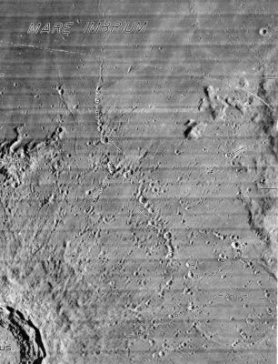
NASA SP-241 Labels for the two named Stadius rilles defined in the System of Lunar Craters can be seen by clicking on the photo. Stadius is the ghost-like ring in the lower right. Copernicus is partially visible in the lower left corner.
Images
LPOD Photo Gallery Lunar Orbiter Images Apollo Images
Maps
(LAC zone 58B3) LAC map Geologic map
Description
These classically-named rilles were intended to denote particularly prominent chains of craters in an area battered with secondaries from the Copernicus impact. As noted in the IAU Planetary Gazetteer, they should more properly be called catenae.
Additional Information
Nomenclature
- Named after the nearby crater (Stadius).
- Mary Blagg's Collated List (1913) included four rilles named after Stadius (Catalog entries 1477-1480).
- These were incorporated into Named Lunar Formations (1935) as Stadius Ir through IVr (see map).
- The System of Lunar Craters reduced the number to two. Rima Stadius I runs north from Stadius M and corresponds to the former Stadius IVr. Rima Stadius II is depicted as running southwest from Stadius W and corresponds to the former Stadius IIIr. Stadius Ir and IIr (which were closer to Stadius) were dropped.
- LAC 58 defines Rima Stadius II as extending in both directions from Stadius W
- The features depicted in the System of Lunar Craters were initially listed as Rimae Stadius in the new IAU Planetary Gazetteer, but that name was latter dropped. The on-line Gazetteer lists the drop date as 1985 and the reason as "a catena, not a rima." No mention of the dropping of this, and several other names listed as having been dropped in that year, appears to have been made in the IAU Transactions for 1985.
- Often called the Stadius Craterlets in lots of popular moonbooks.
LPOD Articles
Bibliography