Rükl 15
Contents
[hide]Rükl Zone 15 - ATLAS
Neighboring maps on the Rükl Nearside Map:
| 15 |
||
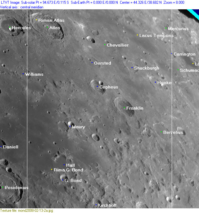
Photographic Map
(This map is based on an Earth-based photograph that has been computer-corrected to zero libration. The vertical white lines indicate the left and right boundaries of the Rükl rectangle)

  Background image source
Named Features
- Atlas (Van Langren's Blitterswyckii, J.Hewelcke's Montes Macrocemnii) (note: indeed, Riccioli's Atlas sounds a lot more mouth-friendly).
- Atlas companion (an unofficial name from B.Dembowski for the exceptionally bright ray-craterlet east of Atlas) (one of the signposts for observations of lunar eclipses) (see also LROC article Brush Strokes on a Lunar Canvas; shows a close-up of a small section of the ejectablanket of B.Dembowski's Atlas companion).
- Atlas P, an irregular "crater" east-northeast of Atlas itself (northwest of Lacus Temporis, see the lower part of Rukl's chart 7) has a pronounced hill on the eastern part of its rim. According to SLC map B1, that hill received the Greek letter designation Epsilon (Atlas Epsilon?). See SLC-B1 (System of Lunar Craters, 1966).
- Barlaei (Van Langren's disallowed name for Atlas A or Atlas Alpha).
- Basin U4 (unofficial name, see description near bottom of this Rukl page).
- Berzelius
- Carrington
- Cepheus (Van Langren's Vossii) (J.Hewelcke's Mons Bodinus, together with the IAU's Franklin).
- Chevallier (and the exceptionally bright ray-craterlet north of it, unofficially called Atlas companion by B.Dembowski).
- Franklin (Van Langren's Hensii) (J.Hewelcke's Mons Bodinus, together with the IAU's Cepheus).
- G. Bond
- Hall
- Hooke
- Kirchhoff
- Lacus Somniorum (the eastern part of it was called Sinus Carcinites by J.Hewelcke, it's occupying the lower left section of Chart 15, for wiki-link see Chart 14).
- Lacus Temporis (once called Mare Horologii by J.P.H.Fauth and E.Debes).
- Mercurius (Van Langren's Hugenii, Riccioli's Osymandies).
- Oersted
- Paludes Hyperboreae (J.Hewelcke's disallowed name for the vague dark area north of Berzelius).
- Rima G. Bond
- Rima Newcomb (discontinued IAU name) (the southern three-fourths of Newcomb itself are depicted on Rukl Zone 25).
- Rimae Atlas
- Shuckburgh
- Sinus Carcinites (J.Hewelcke's disallowed name for the eastern part of Lacus Somniorum).
- Terra Sapientiae (Van Langren's disallowed name for the region at the lower right part of Chart 15).
- Terra Vitae (Riccioli's discontinued name for the region at the lower right part of Chart 15).
- Touchet (a disallowed name from F.C.Lamech for Maury A, southeast of Maury itself).
Lettered Crater Locations
(click on the thumbnails to display full-sized images; use browser BACK button to return - the dashed white lines are the midpoints of the Rükl zones)

  Full zone with lettered craters:


  Lettered craters by quadrants:
| North West |
North East |
| South West |
South East |
Additional Information
- Other online descriptions of features in this Rükl map section:
Basin U4
The upper right corner of Rukl's Zone 15 seems to be the location of the centre of an unnamed basin, known as U4. See nearside chart in page Lunar Basins List. - DannyCaes Sep 22, 2013


