Alhazen
Contents
Alhazen
|
Lat: 15.9°N, Long: 71.8°E, Diam: 32 km, Depth: 2.17 km, Rükl: 27 |
Table of Contents

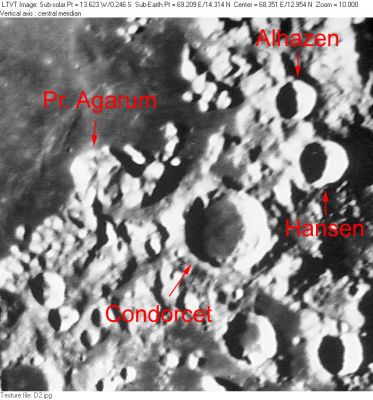
Consolidated Lunar Atlas plate D2 The labeled features in this rectified version of the Consolidated Lunar Atlas plate are Condorcet, Promontorium Agarum, Alhazen and Hansen. Also visible, but not labeled, are Dorsa Harker (to the west of Pr. Agarum); Mons Usov; Auzout, van Albada and Krogh; the northeast part of Firmicus (in the lower left corner), and the northern part of Mare Undarum (along most of the lower margin).
Images
LPOD Photo Gallery Lunar Orbiter Images Apollo Images
It would be interesting to know one or more science-related facts related to the two black arrows near the right margin of Apollo 17's orbital ITEK-panoramic frame AS17-P-2172. Both arrows are pointing to something on the dark floor of Alhazen B.
Detection of Alhazen B plus two black arrows on frame AS17-P-2172: Danny Caes
Maps
(LAC zone 63A1) USGS Digital Atlas PDF
Description
Description: Elger
(IAU Directions) ALHAZEN.--This ring-plain, rather smaller than Hansen, is the most northerly of the linear chain of formations, associated with the highlands bordering the S.E. and the E. flanks of the Mare Crisium. It has a central mountain and other minor elevations on the floor. There is a little ring between Alhazen and Hansen, never very conspicuous in the telescope, which is plainly traceable in good photographs.
Description: Wikipedia
Additional Information
Depth data from Kurt Fisher database
- Westfall, 2000: 2.17 km
- Cherrington, 1969: 1.58 km
Nomenclature
- Named for Abu ‘Ali al-Hasan ibn al-Hasan ibn al-Haytham (965–1039) (Alhazen), a Muslim polymath, astronomer, engineer, mathematician, physicist, and scientist, who made significant contributions to the principles of optics, as well as motion, number theory, analytical geometry, and integral calculus, and established the use of the experimental scientific method.
- Alhazen E was called Recorde by Wilkins and Moore, but the IAU did not accept that name. Recordewas a Welsh scientist (1510-1558).
- Alhazen Alpha and Alhazen Beta (two prominent mountains at the eastern part of Mare Crisium's (or the Crisium basin's) rim, northwest of Alhazen) (see Chart 34 in the Times Atlas of the Moon).
The Alhazen Controversy
The name Alhazen seems to have been a matter of some controversy in the 19th century. Johann Schröter introduced the name as a label for what appears to be a prominent crater in the eastern rim of Mare Crisium (Schröter's illustration is south up), and in the text of his book evidently mentions having frequently used it as a reference point for measuring and describing the positions of nearby features. However, later some later observers were unable to detect a crater at this location. The debate between Kunowsky and Köhler over whether Schröter’s Alhazen had disappeared or not is recounted in Webb and in Neison. It led Beer and Mädler to reassign the name to the crater presently recognized as Alhazen by the IAU. In 1862, the British selenographer W. R. Birt concluded, with good reason, that Schröter’s Alhazen simply referred to a pair of ridges still prominent in the location indicated by Schröter. When the waxing crescent Moon is observed with moderate to low resolution (as Schröter depicted it in his illustration), this feature looks very much like a crater, as does a more isolated peak to its south, also depicted by Schröter as a crater. The two ridges forming Schröter’s Alhazen seem to have been called Mare Anguis Xi and Alhazen Alpha in Blagg and Müller, with the more southerly crater-like appearance corresponding to Alhazen Beta. Similar controversies about real changes happening on the Moon over the time span between various historic maps arose in connection with Linné and Hyginus N, as well as the Plato craterlets.
LPOD Articles
A Single Peak
Mountains by the Sea
Bibliography
- Birt, W. R. 1862. On a Re-discovery of the missing Lunar Crater, Alhazen, situated on the western border of the Mare Crisium. Monthly Notices of the Royal Astronomical Society, Vol. 22, pp. 229-231.
- Birt, W. R. 1867. The Lunar Crater Alhazen. Astronomical register, vol. 5, p. 170.
- Harold Hill. A Portfolio of Lunar Drawings, pages 28, 29 (Alhazen alpha).
- Wilkins and Moore: Alhazen E ("Recorde").
This page has been edited 1 times. The last modification was made by - tychocrater tychocrater on Jun 13, 2009 3:24 pm - afx3u2