Samir
Contents
[hide]Samir (about halfway between Delisle and Diophantus)
|
Lat: 28.5°N, Long: 34.29°W, Diam: 1.86 km, Depth: 0.418 km, Rükl: 19 | |
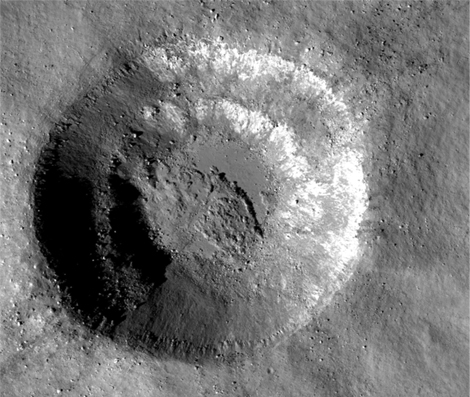
Right: LROC NAC image - M104740941LE.
Images
LPOD Photo Gallery Lunar Orbiter Images Apollo Images
- Apollo 15's orbital Hasselblad photograph AS15-92-12460 shows a close-up of both Samir and its small nearby companion Louise.
- Apollo 15's orbital ITEK-panoramic frames which show Samir and Louise:
- AS15-P-10295 and AS15-P-10290 (on both frames: scroll to the right (north) of the pronounced crater Diophantus).
- Research Apollo 15 photographs: Danny Caes
Maps
(LAC zone 39B2) LAC map Geologic map LM map LTO map Topophotomap
Description
The larger of a pair of craters situated to the SW of a bend in the Diophantus Rille. The smaller crater, 2.5 km to the east, is Louise. The pair is surrounded by a blanket of bright ejecta, suggesting that at least one of them resulted from a relatively fresh impact. Samir has a relatively flat floor, a little less than 1 km in diameter.
 - JimMosher
Elger
(IAU Directions) S. of DELISLE there is a tolerably bright spot on the site of some hills.
Wikipedia
Additional Information
- IAU page: Samir
- In comparison to the current official IAU data listed in the title line, the position and dimensions in the older coordinate system of the topophotomap as read by LTVT were: Lat: 28.492°N, Long: 34.306°W, Diam: 1.9 km. The depth listed in the title line was read from the highest point on the rim to the lowest point on the floor. On the topophotomap, the deepest point is indicated as falling at 28.498N/34.302W. The elevation of that point is listed as 5176 m. Strangely, on the lower resolution LTO-39B2, the elevation is given as 5163 m. Usually the LTO copies the information from the topophotomap.
- From the shadows in AS15-M-2332, Samir is about 400 m deep, roughly confirming the validity of the topophotomap contours. Louise is about 140 m deep. - JimMosher
- The pairing of Samir and Louise, with their surrounding bright ejecta, is reminiscent of the pairing of Censorinus and Censorinus A. In the latter case it seems clear that the bright ejecta originate in the smaller of the two craters (Censorinus). In the present case, it appears (but is much less clear) that the reverse is true: the larger crater, Samir (similar in size, incidentally, to Censorinus), seems to be the source of the ejecta. - JimMosher
- Moore et al, 1980 lists the "small crater between Delisle and Diophantus" as a thermal anomaly crater, implying youthful age - - but which is the anomaly crater, Louise or Samir?
Nomenclature
- Samir is a generic Arabic male name. It honors no particular person.
- According to NASA RP-1097, Samir is a Minor Feature whose name was originally intended only for use in connection with Topophotomap 39B2/S1(on which it is plotted).
- In addition to Samir and Louise, the other Minor Features labeled on Topophotomap 39B2/S1 are Isabel and Walter.
All these names were among 95 Topophotomap Minor Feature names approved by the IAU in 1976 (IAU Transactions XVIIB). - Much confusion about Samir exists because in Antonin Rükl's popular Atlas of the Moon only a single crater is plotted at this location, and it is labeled Louise with a special arrow pointing to it. Similarly, in the popular Virtual Moon Atlas freeware program, only a single name is given in this region, and that name is "Louise". Rükl's reason for choosing the name Louise is unknown. In all likelihood, the crater he drew and labeled is Samir.
- In the original IAU nomenclature of Blagg and Müller there was a Greek-lettered peak known as Diophantus Alpha in this vicinity. This is probably the bright spot refered to by Elger, the spot being produced by the bright ejecta around Samir and Louise.
- JimMosher
LPOD Articles
Bibliography
Named Features -- Prev: Saha -- Next: Sampson

