Lacus Veris
Contents
Lacus Veris
(original IAU name: Mare Veris)
|
Lat: 16.5°S, Long: 86.1°W, Diam: 396 km, Depth: km, Rükl: 50 |

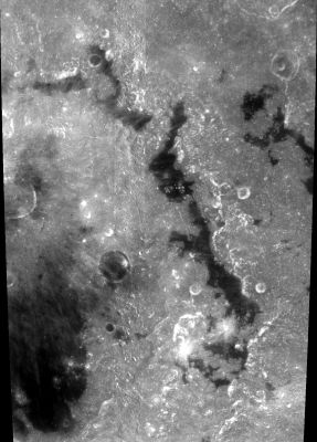
Clementine Lacus Veris refers to the long skinny chain of mare "lakes" extending through the center of this image. The detached part in the upper right is separately known as Lacus Autumni, while the much broader piece in the lower left is Mare Orientale (the central mare of the Orientale Basin). The circular dark-floored 41-km crater Kopff lies between Lacus Veris and the central mare.
Images
LPOD Photo Gallery Lunar Orbiter Images
Orbital Apollo photographs of Lacus Veris (in Earthshine) are online in Apollo 17's Nikon Magazine 158-WW.- DannyCaes Feb 20, 2014
Maps
(LAC zone 91A1) USGS Digital Atlas PDF
Description
Description: Wikipedia
Additional Information
Nomenclature
- The IAU name means "Lake of Spring", a modernized form of Mare Veris ("Spring Sea") one of a set of "four seasons" names given by Franz in his Die Randlandschaften des Mondes (1913) to previously unnamed dark patches in this area. The others were Mare Aestatis (Summer), Mare Autumni (Fall), and Mare Hiemis (Winter). The relevant section of Franz' map is reproduced as Figure 7 in Baum and Whitaker, 2007 (p. 132).
- In 1961 (IAU Transactions XIB) the IAU approved certain changes in the boundary of the feature meant by this name, as introduced in Table III of the Photographic Lunar Atlas (1960). These were said to be necessary to restore it to the feature intended by Franz.
- In 1970 the IAU changed the name from "Mare" to "Lacus" (IAU Transactions XIVB, Menzel, 1971).
LPOD Articles
Bibliography