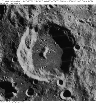
Bettinus
Contents
Bettinus
|
Lat: 63.4°S, Long: 44.8°W, Diam: 71 km, Depth: 3.69 km, Rükl: 71 |
LO-IV-154H Several lettered craters named after Bettinus are visible here. These include Bettinus F, the 6-km crater on the main crater's northeast floor, nearly covered by shadow; 7-km Bettinus E, on the rim nearby; 8-km Bettinus H, also on the rim at 5 o'clock; 9-km Bettinus D, outside the rim at 7 o'clock; and ragged 26-km Bettinus A in the lower left corner. The 12-km crater along the lower right margin (below Bettinus H) is Kircher B, named for the nearby crater to the south.
Images
LPOD Photo Gallery Lunar Orbiter Images
Maps
(LAC zone 125D4) LAC map Geologic map USGS Nomenclature maps (PDF): north south
Description
Description: Elger
(IAU Directions) BETTINUS.--Another ring-plain of the same type and size, some distance S. of Zuchius, with a massive border, terraced within, and rising on the E. more than 13,000 feet above the floor, on which stands a grand central mountain, whose brilliant summit is in sunlight a long time before a ray reaches any part of the deep interior.
Description: Wikipedia
Additional Information
- Depth data from Kurt Fisher database
- Westfall, 2000: 3.69 km
- Viscardy, 1985: 3.3 km
- Cherrington, 1969: 3.81 km
- Central peak composition: Anorthosite & GNTA1 (Tompkins & Pieters, 1999)
Nomenclature
- Named for Mario Bettinus (February 6, 1582 - November 7, 1657), an Italian Jesuit philosopher, mathematician and astronomer. His Apiaria Universae Philosophiae Mathematicae is an encyclopedic collection of mathematical curiosities.
- According to Whitaker (p. 211), this was one of the original names from Riccioli's map, where it was listed as Bettinus Soc. I (the "Soc. I" standing for "Society of Jesus" -- see the list of Jesuit astronomers).
LPOD Articles
Bibliography
