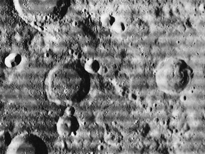
Abulfeda crater chain
Contents
Catena Abulfeda
(official IAU name, also known informally as Abulfeda crater chain)
|
Lat: 16.61°S, Long: 16.68°E, Length: 209.97 km, Depth: km, Rükl: 56 and 57 |

LOIV 089 H2 The Abulfeda crater chain starts in the upper left corner and goes to the lower right corner of this image.
Images
LPOD Photo Gallery Lunar Orbiter Images Apollo Images
- Most of Apollo 16's southward-looking orbital photographs of Catena Abulfeda are online in the LPI's list of crater Abulfeda itself.
- Lunar Orbiter 5's Frame 084 shows a close-up of the northern part of Catena Abulfeda and the southern half of the adjacent crater Abulfeda.
- Research: Danny Caes
Maps
(LAC zone 96A2) LAC map Geologic map
Description
Wikipedia
Additional Information
- IAU page: Catena Abulfeda
- List of Lunar Catenae.
- Abulfeda crater chain is thought to have formed from impacts of a disrupted comet. - tychocrater Jun 23, 2007
Nomenclature
Named from nearby crater. (Abulfeda)
LPOD Articles
Bibliography
- Apollo Over the Moon, Chapter 3: The Terrae (Part 2), Figure 45.
- Don E. Wilhelms, To a Rocky Moon: a Geologist's History of Lunar Exploration, Page 286 (Abulfeda Chain).
Named Features -- Prev: Abulfeda -- Next: Acosta