Alpine Valley
Contents
Alpine Valley
(current IAU name: Vallis Alpes)
|
Lat: 49.21°N, Long: 3.63°E, Length: 155.42 km, Depth: km, Rükl: 12 |


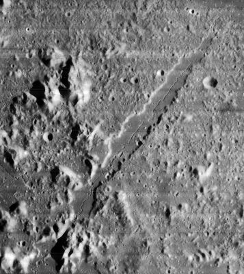
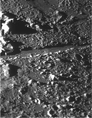
Left: Lunar Orbiter IV submitted by Stefan Lammel, Right: Wes Higgins
Table of Contents
Images
LPOD Photo Gallery Lunar Orbiter Images SMART-1
Kaguya flyover
- An impressive orbital photograph of the Alpine Valley (made by Lunar Orbiter 5, Frame 102) was included on pages 236-237 in the National Geographic of February 1969 (Awesome Views of the Forbidding Moonscape; a nine-page portfolio). Research: Danny Caes.
Paintings and drawings of the Alpine Valley
The book The Conquest of Space (Willy Ley, 1951) contains a wonderful illustration of the Alpine Valley, painted by Chesley Bonestell. It shows an earthlit oblique west-southwest view of the valley's southwestern part and adjacent Mare Imbrium with Mons Pico in the distance. Although well painted, there seems to be an error in it, because there's a solar eclipse caused by the distant mountain Pico at the horizon, while Pico's shadow runs too much "to the right" instead of "toward the observer". I want to know why Chesley Bonestell painted it this way.
  The Dutch translation of this book (De Sprong in het Heelal) shows this illustration as Plate XXIII, between pages 38 and 39.
 - DannyCaes DannyCaes Apr 15, 2012
Maps
(LAC zone 12C3) LAC map Geologic map
Description
Elger
(IAU Directions) THE GREAT ALPINE VALLEY.--A great wedge-shaped depression, cutting through the Alps E. of Plato, from E.N.E. to W.S.W. It is more than 80 miles in length, and varies in breadth from 6 miles on the S. to less than 4 miles on the N., where it approaches the S. border of the Mare Frigoris. For a greater part of its extent it is bounded on the S.E. side by a precipitous linear cliff, which, under a low evening sun, is seen to be fringed by a row of bright little hills. These are traceable up to one of the great mountain masses of the Alps, forming the S.E. side of the great oval-shaped expansion of the valley, whose shape has been appropriately compared to that of a Florence oil-flask, and which Webb terms a grand amphitheatre. On the opposite or N.W. side, the boundary of the valley is less regular, following a more or less undulating line up to a point opposite, and a little N. of, the great mountain mass, where it abuts on a shallow quasi enclosure with lofty walls, which, projecting eastwards, considerably diminish the width of the valley. South of this lies another curved mountain ring, which still farther narrows it. This curtailment in width represents the neck of the flask, and is apparently about 16 or 17 miles in length, and from 3 to 4 miles in breadth, forming a gorge, bordered on the E. by nearly vertical cliffs, towering thousands of feet above the bottom of the valley; and on the W. by many peaked mountains of still greater altitude. At the entrance to the amphitheatre, the actual distance between the colossal rocks which flank the defile is certainly not much more than 2 miles. From this standpoint the view across the level interior of the elliptical plain would be of extraordinary magnificence. Towards the S., but more than 12 miles distant, the outlook of an observer would be limited by some of the loftiest peaks of the Alps, whose flanks form the boundary of the enclosure, through which, however, by at least three narrow passes he might perchance get a glimpse of the Mare Imbrium beyond. The broadest of these aligns with the axis of the valley. It is hardly more than a mile wide at its commencement on the S. border of the amphitheatre, but expands rapidly into a trumpet-shaped gorge, flanked on either side by the towering heights of the Alps as it opens out on to the Mare. The bottom, both of the amphitheatre and of the long wedge-shaped valley, appears to be perfectly level, and, as regards the central portion of the latter, without visible detail. Under morning illumination I have, however, frequently seen something resembling a ridge partially crossing the neck, and, near sunset, a tongue of rock jutting out from the W. flank of the constriction, and extending nearly from side to side. At the base of the cliff bordering the valley on the S.E., five or six little circular pits have been noted, some of which appear to have rims. They were seen very perfectly with powers of 350 and 400 on an 8 1/2 inch Calver reflector at 8 h. on January 25, 1885, and have been observed, but less perfectly, on subsequent occasions. The most northerly is about 10 miles from the N.E. end of the formation, and the rest occur at nearly regular intervals between it and the neck. In the neighbourhood of the valley, on either side, there are several bright craters. Three stand near the N.W. edge, and one of considerable size near the N.E. end on the opposite side. A winding cleft crosses the valley about midway, which, strange to say, is not shown in the maps, though it may be seen in a 4 inch achromatic. It originates apparently at a bright triangular mountain on the plain S.E. of the valley, and, after crossing the latter somewhat obliquely, is lost amid the mountains on the opposite side. That portion of it on the bottom of the valley is easily traceable under a high light as a white line. The region N. of the Alps on the S.E. side of the valley presents many details worthy of examination. Among them, parallel rows of little hills, all extending from N.E. to S.W. There is also a number of still smaller objects of the same type on the W. side. The great Alpine valley, though first described by Schroter, is said to have been discovered on September 22, 1727, by Bianchini, but it is very unlikely that an object which is so prominent when near the terminator was not often remarked before this.
Wikipedia
Additional Information
- IAU page: Vallis Alpes
- Discovered by Bianchini Sept 27, 1727 in Rome with a 75 ft aerial telescope. Sheehan & Dobbins, p 40. But note that Elger above said Sept 22!?
- According to stereo mapping the Valley walls are <1 km high.
- For the dimensions of the rille that runs down the middle of the valley, see Alpine Valley central rille.
Nomenclature
- Named after the "Montes Alpes" range in which it is found, which are in turn named after the Alps Mountains on Earth.
- Whitaker (p 229) reports that Neison is apparently the originator of this name.
- Although listed as Alpine Valley in the original IAU nomenclature of Blagg and Muller's Named Lunar Features, the current official name is Vallis Alpes. The name change probably occurred in connection with the adoption of Arthur's System of Lunar Craters in about 1963. - JimMosher JimMosher
- I was a coauthor of the Arthur catalog. The 1961 IAU meeting authorized the latinization of names of types of features, such as vallis, mons, montes. Our System of Lunar Craters was probably the first place these new Latin abominations (I still don't like them) were introduced. - TychoCrater TychoCrater
- Amphitheatre and Florence oil-flask are two nicknames for the southwestern end of the Alpine valley (see T.G.Elger's description above).
LPOD Articles
Sinuous rille History A Gash and a River. Schroeter & Pickering & Keene Early News About a Remarkable Object Valley of the Alpes Lacus Niger MajorA Classic View Charcoal Excursion A New Idea Slip-Sliding Away Unfamiliar View
LROC Articles
Lunar 100
L19: Lunar graben.
Bibliography
- Cook, A.C. and Hiesinger, H (1996) Preliminary Analysis of Clementine Imagery of the Alpine Valley LPSC volume 27, page 249.
- Wood, C.A. 11/2006. Imbrium Mayhem. S&T 112(5)54-55
Named Featues -- Prev: Montes Alpes -- Next: Alpetragius
This page has been edited 1 times. The last modification was made by - tychocrater tychocrater on Jun 13, 2009 3:24 pm - afx3u3