Difference between revisions of "Archytas"
(Created page with "<div id="content_view" class="wiki" style="display: block"> =Archytas= {| class="wiki_table" | Lat: 58.7°N, Long: 5.0°E, Diam: 31 km, Depth: 2.94 km, [/R%C3%BCkl%204 Rü...") |
|||
| Line 3: | Line 3: | ||
{| class="wiki_table" | {| class="wiki_table" | ||
| | | | ||
| − | Lat: 58.7°N, Long: 5.0°E, Diam: 31 km, Depth: 2.94 km, [ | + | Lat: 58.7°N, Long: 5.0°E, Diam: 31 km, Depth: 2.94 km, [[R%C3%BCkl%204|Rükl: 4]], [[Stratigraphy|Eratosthenian,]]<br /> |
| | | | ||
| − | [ | + | [[Crater%20Classification|Tri]]<br /> |
|} | |} | ||
<div id="toc"> | <div id="toc"> | ||
| Line 13: | Line 13: | ||
[http://www.lpod.org/coppermine/thumbnails.php?album=search&type=full&search=Archytas LPOD Photo Gallery] [http://www.lpi.usra.edu/resources/lunar_orbiter/bin/srch_nam.shtml?Archytas%7C0 Lunar Orbiter Images] [http://www.lpi.usra.edu/resources/lunar_orbiter/images/aimg/iv_116_h1.jpg Location]<br /> '''Archytas G''', the first item in C.A.Wood's list of Concentric Craters (1978) is noticeable near the centre of Lunar Orbiter 4's photograph [http://www.lpi.usra.edu/resources/lunarorbiter/images/preview/4116_h1.jpg LOIV-116-h1].<br /> Research: Danny Caes<br /> <br /> | [http://www.lpod.org/coppermine/thumbnails.php?album=search&type=full&search=Archytas LPOD Photo Gallery] [http://www.lpi.usra.edu/resources/lunar_orbiter/bin/srch_nam.shtml?Archytas%7C0 Lunar Orbiter Images] [http://www.lpi.usra.edu/resources/lunar_orbiter/images/aimg/iv_116_h1.jpg Location]<br /> '''Archytas G''', the first item in C.A.Wood's list of Concentric Craters (1978) is noticeable near the centre of Lunar Orbiter 4's photograph [http://www.lpi.usra.edu/resources/lunarorbiter/images/preview/4116_h1.jpg LOIV-116-h1].<br /> Research: Danny Caes<br /> <br /> | ||
==Maps== | ==Maps== | ||
| − | ''([ | + | ''([[LAC%20zone|LAC zone]] 12B3)'' [http://www.lpi.usra.edu/resources/mapcatalog/LAC/lac12/ LAC map] [http://www.lpi.usra.edu/resources/mapcatalog/usgs/I701/ Geologic map]<br /> <br /> |
==Description== | ==Description== | ||
<br /> | <br /> | ||
==Description: Elger== | ==Description: Elger== | ||
| − | ''([ | + | ''([[IAU%20Directions|IAU Directions]])'' ARCHYTAS.--A bright ring-plain, 21 miles in diameter, on the edge of the [[Mare%20Frigoris|Mare Frigoris]], due N. of the [[Alpine%20Valley|Alpine Valley]], with regular walls rising about 5,000 feet above the interior on the N.E., and about 4,000 feet on the opposite side. It has a very bright central mountain. Several spurs radiate from the wall on the S., and a wide valley, flanked by lofty heights, forming the S.E. boundary of [[W.%20Bond|W.C. Bond]], originates on the N side. There is also a crater-rill running towards the N.E. On the Mare, S.E. of Archytas, is a somewhat smaller ring-plain, Archytas A (called by Schmidt, PROTAGORAS), with lofty walls and a central hill.<br /> <br /> |
==Description: Wikipedia== | ==Description: Wikipedia== | ||
[http://en.wikipedia.org/wiki/Archytas_(crater) Archytas]<br /> <br /> | [http://en.wikipedia.org/wiki/Archytas_(crater) Archytas]<br /> <br /> | ||
==Additional Information== | ==Additional Information== | ||
| − | * Depth data from [ | + | * Depth data from [[Kurt%20Fisher%20crater%20depths|Kurt Fisher database]] |
** Westfall, 2000: 2.94 km | ** Westfall, 2000: 2.94 km | ||
** Viscardy, 1985: 2.35 km | ** Viscardy, 1985: 2.35 km | ||
* Central peak height | * Central peak height | ||
| − | ** [ | + | ** [[Wood%2C%201971|Wood, 1971]]: 0.68 km <span class="membersnap">- [http://www.wikispaces.com/user/view/tychocrater [[Image:tychocrater-lg.jpg|16px|tychocrater]]] [http://www.wikispaces.com/user/view/tychocrater tychocrater] <small>Mar 17, 2008</small></span> |
| − | ** [ | + | ** [[Sekiguchi%2C%201972|Sekiguchi, 1972]]: 0.6 km <span class="membersnap">- [http://www.wikispaces.com/user/view/fatastronomer [[Image:fatastronomer-lg.jpg|16px|fatastronomer]]] [http://www.wikispaces.com/user/view/fatastronomer fatastronomer]</span> |
| − | * '''[http://lpod.org/coppermine/displayimage.php?pos=-707 Archytas G]''' is a [ | + | * '''[http://lpod.org/coppermine/displayimage.php?pos=-707 Archytas G]''' is a [[concentric%20crater|concentric crater]]. |
| − | * TSI = 25, CPI = 20, FI = 20; MI =65 [ | + | * TSI = 25, CPI = 20, FI = 20; MI =65 [[Smith%20and%20Sanchez%2C%201973|Smith and Sanchez, 1973]] |
<br /> | <br /> | ||
==Nomenclature== | ==Nomenclature== | ||
Revision as of 14:39, 15 April 2018
Contents
Archytas
|
Lat: 58.7°N, Long: 5.0°E, Diam: 31 km, Depth: 2.94 km, Rükl: 4, Eratosthenian, |
Table of Contents

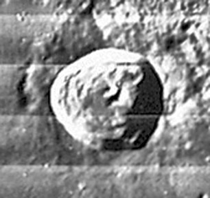
LO-IV-116-h1
Images
LPOD Photo Gallery Lunar Orbiter Images Location
Archytas G, the first item in C.A.Wood's list of Concentric Craters (1978) is noticeable near the centre of Lunar Orbiter 4's photograph LOIV-116-h1.
Research: Danny Caes
Maps
(LAC zone 12B3) LAC map Geologic map
Description
Description: Elger
(IAU Directions) ARCHYTAS.--A bright ring-plain, 21 miles in diameter, on the edge of the Mare Frigoris, due N. of the Alpine Valley, with regular walls rising about 5,000 feet above the interior on the N.E., and about 4,000 feet on the opposite side. It has a very bright central mountain. Several spurs radiate from the wall on the S., and a wide valley, flanked by lofty heights, forming the S.E. boundary of W.C. Bond, originates on the N side. There is also a crater-rill running towards the N.E. On the Mare, S.E. of Archytas, is a somewhat smaller ring-plain, Archytas A (called by Schmidt, PROTAGORAS), with lofty walls and a central hill.
Description: Wikipedia
Additional Information
- Depth data from Kurt Fisher database
- Westfall, 2000: 2.94 km
- Viscardy, 1985: 2.35 km
- Central peak height
- Wood, 1971: 0.68 km - tychocrater tychocrater Mar 17, 2008
- Sekiguchi, 1972: 0.6 km - fatastronomer fatastronomer
- Archytas G is a concentric crater.
- TSI = 25, CPI = 20, FI = 20; MI =65 Smith and Sanchez, 1973
Nomenclature
Archytas (428 BC – 347 BC) was an Ancient Greek philosopher, mathematician, astronomer, statesman, and strategist.
LPOD Articles
Bibliography
This page has been edited 1 times. The last modification was made by - tychocrater tychocrater on Jun 13, 2009 3:24 pm - afx3u2