Difference between revisions of "Montes Taurus"
| Line 6: | Line 6: | ||
|} | |} | ||
<div id="toc"> | <div id="toc"> | ||
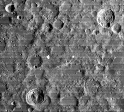
| − | [http://www.lpod.org/coppermine/displayimage.php?pid=239&fullsize=1 [[Image: | + | [http://www.lpod.org/coppermine/displayimage.php?pid=239&fullsize=1 [[Image:Normal_Taurus%20Mts-LOIV-074-H1.jpg|external image normal_Taurus%20Mts-LOIV-074-H1.jpg]]]<br /> ''[http://lpod.org/coppermine/displayimage.php?pos=-239 LOIV-074-H1]'' This view extends from 39-km diameter [[R%C3%B6mer|Römer]] (in the lower right) to 41-km [[Newcomb|Newcomb]] in the upper right. '''Montes Taurus''' refers to most of the hilly region between these two craters. The 20-km crater in the upper left is [[G.%20Bond|G. Bond]]. It lies outside the '''Montes Taurus''' area, whose boundary (according to the IAU position and diameter) is apparently closer to [[Kirchhoff|Kirchhoff]], the more deeply shadowed of the 24-km craters at about 4 o'clock from [[G.%20Bond|G. Bond]].<br /> <br /> |
==Images== | ==Images== | ||
[http://www.lpod.org/coppermine/thumbnails.php?album=search&type=full&search=Montes%20Taurus LPOD Photo Gallery] [http://www.lpi.usra.edu/resources/lunar_orbiter/bin/srch_nam.shtml?Montes%20Taurus%7C0 Lunar Orbiter Images] [http://www.lpi.usra.edu/resources/apollo/search/feature/?feature=Montes%20Taurus Apollo Images]<br /> <br /> | [http://www.lpod.org/coppermine/thumbnails.php?album=search&type=full&search=Montes%20Taurus LPOD Photo Gallery] [http://www.lpi.usra.edu/resources/lunar_orbiter/bin/srch_nam.shtml?Montes%20Taurus%7C0 Lunar Orbiter Images] [http://www.lpi.usra.edu/resources/apollo/search/feature/?feature=Montes%20Taurus Apollo Images]<br /> <br /> | ||
| Line 14: | Line 14: | ||
<br /> | <br /> | ||
==Description: Elger== | ==Description: Elger== | ||
| − | ''([[IAU% | + | ''([[IAU%20directions|IAU Directions]])'' THE TAURUS MOUNTAINS.--extend from the east side of the [[Mare%20Serenitatis|Mare Serenitatis]], near [[Le%20Monnier|Le Monnier]] and [[Littrow|Littrow]], in a north-easterly direction towards [[Geminus|Geminus]] and [[Berzelius|Berselius]], bordering the east side of the [[Lacus%20Somniorum|Lacus Somniorum]]. They are a far less remarkable system than any of the preceding, and consist rather of a wild irregular mountain region than a range. In the neighbourhood of [[Berzelius|Berselius]] are some peaks which, according to Neison, cannot be less than 10,000 feet in height.<br /> |
* ''Note: the range described by Elger spans a length of more than 700 km -- far more expansive than the current IAU definition.'' | * ''Note: the range described by Elger spans a length of more than 700 km -- far more expansive than the current IAU definition.'' | ||
<br /> | <br /> | ||
| Line 20: | Line 20: | ||
[http://en.wikipedia.org/wiki/Montes_Taurus Montes Taurus]<br /> <br /> | [http://en.wikipedia.org/wiki/Montes_Taurus Montes Taurus]<br /> <br /> | ||
==Additional Information== | ==Additional Information== | ||
| − | Depth data from [[Kurt%20Fisher% | + | Depth data from [[Kurt%20Fisher%20Crater%20Depths|Kurt Fisher database]]<br /> |
* Viscardy, 1985: 3 km | * Viscardy, 1985: 3 km | ||
Latest revision as of 02:06, 16 April 2018
Contents
Montes Taurus
|
Lat: 28.4°N, Long: 41.1°E, Diam: 172 km, Height: 3 km, Rükl: 25 |

LOIV-074-H1 This view extends from 39-km diameter Römer (in the lower right) to 41-km Newcomb in the upper right. Montes Taurus refers to most of the hilly region between these two craters. The 20-km crater in the upper left is G. Bond. It lies outside the Montes Taurus area, whose boundary (according to the IAU position and diameter) is apparently closer to Kirchhoff, the more deeply shadowed of the 24-km craters at about 4 o'clock from G. Bond.
Images
LPOD Photo Gallery Lunar Orbiter Images Apollo Images
Maps
(LAC zone 43B1) LAC map Geologic map
Description
Description: Elger
(IAU Directions) THE TAURUS MOUNTAINS.--extend from the east side of the Mare Serenitatis, near Le Monnier and Littrow, in a north-easterly direction towards Geminus and Berselius, bordering the east side of the Lacus Somniorum. They are a far less remarkable system than any of the preceding, and consist rather of a wild irregular mountain region than a range. In the neighbourhood of Berselius are some peaks which, according to Neison, cannot be less than 10,000 feet in height.
- Note: the range described by Elger spans a length of more than 700 km -- far more expansive than the current IAU definition.
Description: Wikipedia
Additional Information
Depth data from Kurt Fisher database
- Viscardy, 1985: 3 km
- Cherrington, 1969: 2.98 km
Nomenclature
- Named after the terrestrial Taurus Mts in southern Turkey.
- According to Whitaker (p. 208), the name Mons Taurus was used by Hevelius, but he used the name for a bright ray running east from Tycho. It is not clear from Whitaker's book who first associated the name with the modern feature.
- In the original IAU Nomenclature of Blagg and Müller (1935), this range was known as the Taurus Mts.
- The name was Latinized to Montes Taurus in IAU Transactions XIIB (1964).
LPOD Articles
Bibliography
For those who might be interested in geophysical luminous phenomena which appear in the terrestrial Taurus mountains: Lights in the Taurus Mountains.