Difference between revisions of "Liouville"
| Line 23: | Line 23: | ||
==Additional Information== | ==Additional Information== | ||
| − | * Depth data from [[Kurt%20Fisher% | + | * Depth data from [[Kurt%20Fisher%20Crater%20Depths|Kurt Fisher database]] |
** Westfall, 2000: 2.91 km | ** Westfall, 2000: 2.91 km | ||
* [[Concentric%20crater|Concentric crater]] south of '''Liouville''' (mentioned as Number 12: "near '''[[Schubert|Schubert]] N'''" in C.A.Wood's list of 1978). | * [[Concentric%20crater|Concentric crater]] south of '''Liouville''' (mentioned as Number 12: "near '''[[Schubert|Schubert]] N'''" in C.A.Wood's list of 1978). | ||
Latest revision as of 02:01, 16 April 2018
Contents
Liouville
(current IAU name; formerly Dubyago S)
|
Lat: 2.6°N, Long: 73.5°E, Diam: 16 km, Depth: 2.91 km, Rükl 38 |
Images
LPOD Photo Gallery Lunar Orbiter Images Apollo Images
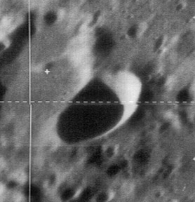
- Lunar Orbiter 1's Frame 026 shows craters Liouville and Respighi (north of the dark mare-like region Schubert N), and Dubyago (near the top left corner of photograph). Note the concentric crater south of Liouville! (almost touching the eastern part of the dark region Schubert N).
- Apollo 11's orbital Hasselblad AS11-42-6298 shows a shadowless close up of Liouville. Warning: the coordinates mentioned in the LPI's caption (at this photograph) are totally wrong!- DannyCaes Aug 20, 2010
- Liouville was also captured on Apollo 16's orbital panoramic ITEK-frame AS16-P-5138. Scroll to the right, beyond the frame's centre, to see Liouville.
- Research Lunar Orbiter and Apollo photography: Danny Caes
Maps
(LAC zone 63D4) LTO map
IAU page
Description
Description: Wikipedia
Additional Information
- Depth data from Kurt Fisher database
- Westfall, 2000: 2.91 km
- Concentric crater south of Liouville (mentioned as Number 12: "near Schubert N" in C.A.Wood's list of 1978).
Nomenclature
- Named for Joseph Liouville (March 24, 1809 - September 8, 1882), a French mathematician. Liouville worked in a number of different fields in mathematics, including number theory, complex analysis, differential geometry and topology, but also mathematical physics and even astronomy.
- This replacement name for a formerly lettered crater was apparently first used on LTO 63D4 (June 1974).
- Since Dubyago was not part of the original IAU nomenclature of Named Lunar Formations, the former name (Dubyago S) probably appeared in the Rectified Lunar Atlas or the System of Lunar Craters.
- The replacement name was approved in IAU Transactions XVIB (1976).
- Not to be confused with Louville.
LPOD Articles
Bibliography
