Difference between revisions of "Louise"
| Line 3: | Line 3: | ||
{| class="wiki_table" | {| class="wiki_table" | ||
| colspan="3" | | | colspan="3" | | ||
| − | Lat: 28.49°N, Long: 34.2°W, Diam: 0.64 km, Depth: 0.126 km, [ | + | Lat: 28.49°N, Long: 34.2°W, Diam: 0.64 km, Depth: 0.126 km, [[R%C3%BCkl%2019|Rükl 19]]<br /> |
|- | |- | ||
| | | | ||
| Line 12: | Line 12: | ||
[http://the-moon.us/wiki/file/detail/louise.jpg [[Image:louise-small.jpg|louise-small.jpg]]]<br /> | [http://the-moon.us/wiki/file/detail/louise.jpg [[Image:louise-small.jpg|louise-small.jpg]]]<br /> | ||
|} | |} | ||
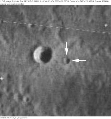
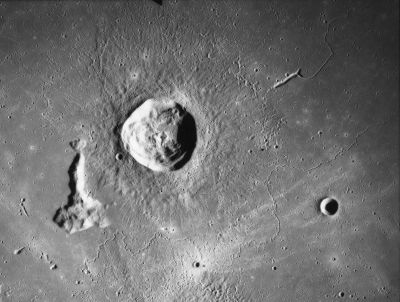
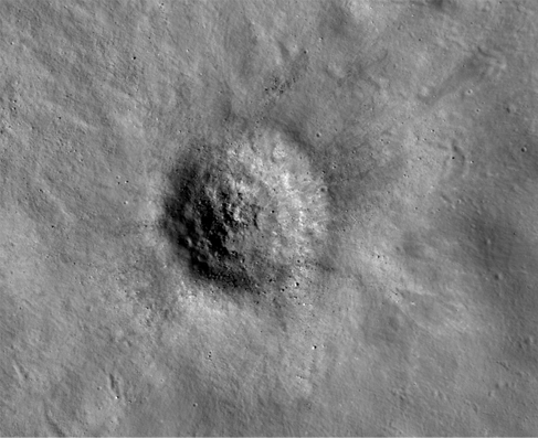
| − | '''Left''': ''[http://lpod.org/coppermine/displayimage.php?pos=-2056 LO-IV-156H]'' '''Louise''' (indicated by white arrows) is to the west of the much larger [ | + | '''Left''': ''[http://lpod.org/coppermine/displayimage.php?pos=-2056 LO-IV-156H]'' '''Louise''' (indicated by white arrows) is to the west of the much larger [[Samir|Samir]].<br /> '''Middle''': ''[http://lpod.org/coppermine/displayimage.php?pos=-459 Apollo 15 AS15-M2332]'' '''Louise''' and [[Samir|Samir]] are near the bottom of the frame, at the center of the region of bright ejecta to the south of [[Delisle|Delisle]].<br /> '''Right:''' [http://wms.lroc.asu.edu/ LROC NAC] image - [http://wms.lroc.asu.edu/lroc/view_lroc/LRO-L-LROC-2-EDR-V1.0/M104740941LE M104740941LE].<br /> <div id="toc"> |
=Table of Contents= | =Table of Contents= | ||
<div style="margin-left: 1em">[#Louise Louise]</div><div style="margin-left: 2em">[#Louise-Images Images]</div><div style="margin-left: 2em">[#Louise-Maps Maps]</div><div style="margin-left: 2em">[#Louise-Description Description]</div><div style="margin-left: 3em">[#Louise-Description-Wikipedia Wikipedia]</div><div style="margin-left: 2em">[#Louise-Additional Information Additional Information]</div><div style="margin-left: 2em">[#Louise-Nomenclature Nomenclature]</div><div style="margin-left: 2em">[#Louise-LPOD Articles LPOD Articles]</div><div style="margin-left: 2em">[#Louise-Bibliography Bibliography]</div></div><br /> | <div style="margin-left: 1em">[#Louise Louise]</div><div style="margin-left: 2em">[#Louise-Images Images]</div><div style="margin-left: 2em">[#Louise-Maps Maps]</div><div style="margin-left: 2em">[#Louise-Description Description]</div><div style="margin-left: 3em">[#Louise-Description-Wikipedia Wikipedia]</div><div style="margin-left: 2em">[#Louise-Additional Information Additional Information]</div><div style="margin-left: 2em">[#Louise-Nomenclature Nomenclature]</div><div style="margin-left: 2em">[#Louise-LPOD Articles LPOD Articles]</div><div style="margin-left: 2em">[#Louise-Bibliography Bibliography]</div></div><br /> | ||
==Images== | ==Images== | ||
[http://www.lpod.org/coppermine/thumbnails.php?album=search&type=full&search=Louise LPOD Photo Gallery] [http://www.lpi.usra.edu/resources/lunar_orbiter/bin/srch_nam.shtml?Louise%7C0 Lunar Orbiter Images] [http://www.lpi.usra.edu/resources/apollo/search/feature/?feature=Louise Apollo Images]<br /> | [http://www.lpod.org/coppermine/thumbnails.php?album=search&type=full&search=Louise LPOD Photo Gallery] [http://www.lpi.usra.edu/resources/lunar_orbiter/bin/srch_nam.shtml?Louise%7C0 Lunar Orbiter Images] [http://www.lpi.usra.edu/resources/apollo/search/feature/?feature=Louise Apollo Images]<br /> | ||
| − | * Apollo 15's orbital Hasselblad photograph [http://www.lpi.usra.edu/resources/apollo/frame/?AS15-92-12460 AS15-92-12460] shows a close-up of both [ | + | * Apollo 15's orbital Hasselblad photograph [http://www.lpi.usra.edu/resources/apollo/frame/?AS15-92-12460 AS15-92-12460] shows a close-up of both [[Samir|Samir]] and its small nearby companion '''Louise'''. |
** Research: Danny Caes | ** Research: Danny Caes | ||
<br /> | <br /> | ||
==Maps== | ==Maps== | ||
| − | ''([ | + | ''([[LAC%20zone|LAC zone]] 39B2)'' [http://www.lpi.usra.edu/resources/mapcatalog/LAC/lac39/ LAC map] [http://www.lpi.usra.edu/resources/mapcatalog/usgs/I465/ Geologic map] [http://www.lpi.usra.edu/resources/mapcatalog/LM/lm39/ LM map] [http://www.lpi.usra.edu/resources/mapcatalog/LTO/lto39b2_1/ LTO map] [http://www.lpi.usra.edu/resources/mapcatalog/topophoto/39B2S1/ Topophotomap]<br /> <br /> |
==Description== | ==Description== | ||
| − | The smaller of a pair of craters situated to the SW of a bend in the [ | + | The smaller of a pair of craters situated to the SW of a bend in the [[Rima%20Diophantus|Diophantus Rille]]. The larger and much more prominent crater 2.5 km to the west is [[Samir|Samir]]. Although the contours in [http://www.lpi.usra.edu/resources/mapcatalog/topophoto/39B2S1/ Topophotomap 39B2/S1] indicate a continuously descending bowl shape with a slightly raised lip, the shadows in the Apollo Metric image suggest '''Louise''' has a low central peak. <span class="membersnap">- [http://www.wikispaces.com/user/view/JimMosher [[Image:JimMosher-lg.jpg|16px|JimMosher]]] [http://www.wikispaces.com/user/view/JimMosher JimMosher]</span><br /> <br /> |
===Wikipedia=== | ===Wikipedia=== | ||
[http://en.wikipedia.org/wiki/Louise_%28crater%29 Louise]<br /> <br /> | [http://en.wikipedia.org/wiki/Louise_%28crater%29 Louise]<br /> <br /> | ||
| Line 29: | Line 29: | ||
* IAU page: [http://planetarynames.wr.usgs.gov/Feature/3483 Louise] | * IAU page: [http://planetarynames.wr.usgs.gov/Feature/3483 Louise] | ||
| − | * Depth data from [ | + | * Depth data from [[Kurt%20Fisher%20crater%20depths|Kurt Fisher database]] |
** Westfall, 2000: 0.26 km | ** Westfall, 2000: 0.26 km | ||
| − | * In comparison to the current official IAU data listed in the title line, the position and dimensions in the older coordinate system of the topophotomap as read by [ | + | * In comparison to the current official IAU data listed in the title line, the position and dimensions in the older coordinate system of the topophotomap as read by [[LTVT|LTVT]] were: Lat: 28.473°N, Long: 34.214°W, Diam: 0.7 km. The depth listed in the title line was read from the highest point on the rim to the "lowest" point on the floor (which, as indicated above, may be the summit of a central peak). |
| − | * Both '''Louise''' and [ | + | * Both '''Louise''' and [[Samir|Samir]] are so small that through Earth-based telescopes what is seen is primarily the dusting of bright ejecta that blankets this area -- most readily visible at high sun angles as in the Apollo metric and Clementine images. It is not entirely clear if the bright ejecta were produced by Louise or [[Samir|Samir]], but they seem centered on the latter. <span class="membersnap">- [http://www.wikispaces.com/user/view/JimMosher [[Image:JimMosher-lg.jpg|16px|JimMosher]]] [http://www.wikispaces.com/user/view/JimMosher JimMosher]</span> |
| − | * [ | + | * [[Moore%20et%20al%2C%201980|Moore et al, 1980]] lists the "small crater between [[Delisle|Delisle]] and [[Diophantus|Diophantus]]" as a thermal anomaly crater, implying youthful age - - but which is the anomaly crater, '''Louise''' or [[Samir|Samir]]? |
| − | * Included in [ | + | * Included in [[ALPO%20list%20of%20bright%20ray%20craters|ALPO list of bright ray craters]] |
<br /> | <br /> | ||
==Nomenclature== | ==Nomenclature== | ||
* '''Louise''' is a generic French female name. It is not meant to honor any particular person. | * '''Louise''' is a generic French female name. It is not meant to honor any particular person. | ||
| − | * According to [ | + | * According to [[NASA%20RP-1097|NASA RP-1097]], '''Louise''' is a [[Minor%20Feature|Minor Feature]] whose name was originally intended only for use in connection with [http://www.lpi.usra.edu/resources/mapcatalog/topophoto/39B2S1/ Topophotomap 39B2/S1](on which it is plotted). |
| − | * In addition to '''Louise''' and [ | + | * In addition to '''Louise''' and [[Samir|Samir]], the other [[Minor%20Feature|Minor Features]] labeled on [http://www.lpi.usra.edu/resources/mapcatalog/topophoto/39B2S1/ Topophotomap 39B2/S1] are [[Isabel|Isabel]] and [[Walter|Walter]]. |
| − | * All these names were among the 95 Topophotomap [ | + | * All these names were among the 95 Topophotomap [[Minor%20Feature|Minor Feature]] names approved by the IAU in 1976 ([[IAU%20Transactions%20XVIIB|IAU Transactions XVIIB]]). |
| − | * Much confusion about '''Louise''' exists because in Antonin Rükl's popular [ | + | * Much confusion about '''Louise''' exists because in Antonin Rükl's popular [[R%C3%BCkl|Atlas of the Moon]] only a single crater is plotted at this location, and it is labeled "Louise" with a special arrow pointing to it. Similarly, in the popular [http://www.astrosurf.com/avl/UK_index.html Virtual Moon Atlas] freeware program, only a single name is given in this region, and that name is "Louise". Rükl's reason for choosing the name '''Louise''' is unknown. In all likelihood, the crater he drew and labeled is [[Samir|Samir]]. |
<br /> | <br /> | ||
==LPOD Articles== | ==LPOD Articles== | ||
| Line 49: | Line 49: | ||
<br /> <br /> | <br /> <br /> | ||
---- | ---- | ||
| − | [ | + | [[Alphabetical%20Index|Named Features]] -- Prev: [[Lorentz|Lorentz]] -- Next: [[Louville|Louville]]<br /> |
---- | ---- | ||
This page has been edited 1 times. The last modification was made by <span class="membersnap">- [http://www.wikispaces.com/user/view/tychocrater [[Image:tychocrater-lg.jpg|16px|tychocrater]]] [http://www.wikispaces.com/user/view/tychocrater tychocrater]</span> on Jun 13, 2009 3:24 pm - ''afx3u3''</div> | This page has been edited 1 times. The last modification was made by <span class="membersnap">- [http://www.wikispaces.com/user/view/tychocrater [[Image:tychocrater-lg.jpg|16px|tychocrater]]] [http://www.wikispaces.com/user/view/tychocrater tychocrater]</span> on Jun 13, 2009 3:24 pm - ''afx3u3''</div> | ||
Revision as of 15:01, 15 April 2018
Contents
Louise
|
Lat: 28.49°N, Long: 34.2°W, Diam: 0.64 km, Depth: 0.126 km, Rükl 19 | ||
Middle: Apollo 15 AS15-M2332 Louise and Samir are near the bottom of the frame, at the center of the region of bright ejecta to the south of Delisle.
Right: LROC NAC image - M104740941LE.
Table of Contents
[#Louise Louise]
[#Louise-Images Images]
[#Louise-Maps Maps]
[#Louise-Description Description]
[#Louise-Description-Wikipedia Wikipedia]
[#Louise-Additional Information Additional Information]
[#Louise-Nomenclature Nomenclature]
[#Louise-LPOD Articles LPOD Articles]
[#Louise-Bibliography Bibliography]
Images
LPOD Photo Gallery Lunar Orbiter Images Apollo Images
- Apollo 15's orbital Hasselblad photograph AS15-92-12460 shows a close-up of both Samir and its small nearby companion Louise.
- Research: Danny Caes
Maps
(LAC zone 39B2) LAC map Geologic map LM map LTO map Topophotomap
Description
The smaller of a pair of craters situated to the SW of a bend in the Diophantus Rille. The larger and much more prominent crater 2.5 km to the west is Samir. Although the contours in Topophotomap 39B2/S1 indicate a continuously descending bowl shape with a slightly raised lip, the shadows in the Apollo Metric image suggest Louise has a low central peak. - JimMosher JimMosher
Wikipedia
Additional Information
- IAU page: Louise
- Depth data from Kurt Fisher database
- Westfall, 2000: 0.26 km
- In comparison to the current official IAU data listed in the title line, the position and dimensions in the older coordinate system of the topophotomap as read by LTVT were: Lat: 28.473°N, Long: 34.214°W, Diam: 0.7 km. The depth listed in the title line was read from the highest point on the rim to the "lowest" point on the floor (which, as indicated above, may be the summit of a central peak).
- Both Louise and Samir are so small that through Earth-based telescopes what is seen is primarily the dusting of bright ejecta that blankets this area -- most readily visible at high sun angles as in the Apollo metric and Clementine images. It is not entirely clear if the bright ejecta were produced by Louise or Samir, but they seem centered on the latter. - JimMosher JimMosher
- Moore et al, 1980 lists the "small crater between Delisle and Diophantus" as a thermal anomaly crater, implying youthful age - - but which is the anomaly crater, Louise or Samir?
- Included in ALPO list of bright ray craters
Nomenclature
- Louise is a generic French female name. It is not meant to honor any particular person.
- According to NASA RP-1097, Louise is a Minor Feature whose name was originally intended only for use in connection with Topophotomap 39B2/S1(on which it is plotted).
- In addition to Louise and Samir, the other Minor Features labeled on Topophotomap 39B2/S1 are Isabel and Walter.
- All these names were among the 95 Topophotomap Minor Feature names approved by the IAU in 1976 (IAU Transactions XVIIB).
- Much confusion about Louise exists because in Antonin Rükl's popular Atlas of the Moon only a single crater is plotted at this location, and it is labeled "Louise" with a special arrow pointing to it. Similarly, in the popular Virtual Moon Atlas freeware program, only a single name is given in this region, and that name is "Louise". Rükl's reason for choosing the name Louise is unknown. In all likelihood, the crater he drew and labeled is Samir.
LPOD Articles
Bibliography
Named Features -- Prev: Lorentz -- Next: Louville
This page has been edited 1 times. The last modification was made by - tychocrater tychocrater on Jun 13, 2009 3:24 pm - afx3u3


