Difference between revisions of "Bohnenberger"
| Line 3: | Line 3: | ||
{| class="wiki_table" | {| class="wiki_table" | ||
| | | | ||
| − | Lat: 16.2°S, Long: 40.0°E, Diam: 33 km, Depth: 2.4 km, [ | + | Lat: 16.2°S, Long: 40.0°E, Diam: 33 km, Depth: 2.4 km, [[R%C3%BCkl%2058|Rükl: 58]]<br /> |
|} | |} | ||
<div id="toc"> | <div id="toc"> | ||
| Line 11: | Line 11: | ||
[http://www.lpod.org/coppermine/thumbnails.php?album=search&type=full&search=Bohnenberger LPOD Photo Gallery] [http://www.lpi.usra.edu/resources/lunar_orbiter/bin/srch_nam.shtml?Bohnenberger%7C0 Lunar Orbiter Images] [http://www.lpi.usra.edu/resources/apollo/search/feature/?feature=Bohnenberger Apollo Images]<br /> <br /> | [http://www.lpod.org/coppermine/thumbnails.php?album=search&type=full&search=Bohnenberger LPOD Photo Gallery] [http://www.lpi.usra.edu/resources/lunar_orbiter/bin/srch_nam.shtml?Bohnenberger%7C0 Lunar Orbiter Images] [http://www.lpi.usra.edu/resources/apollo/search/feature/?feature=Bohnenberger Apollo Images]<br /> <br /> | ||
==Maps== | ==Maps== | ||
| − | ''([ | + | ''([[LAC%20zone|LAC zone]] 97A2)'' [http://www.lpi.usra.edu/resources/mapcatalog/LAC/lac97/ LAC map] [http://www.lpi.usra.edu/resources/mapcatalog/usgs/I720/ Geologic map]<br /> <br /> |
==Description== | ==Description== | ||
<br /> | <br /> | ||
==Description: Elger== | ==Description: Elger== | ||
| − | ''([ | + | ''([[IAU%20Directions|IAU Directions]])'' BOHNENBERGER.--A ring-plain about 22 miles in diameter, situated on the E. side of the [[Mare%20Nectaris|Mare Nectaris]], under the precipitous flanks of [[Montes%20Pyrenaeus|the Pyrenees]], whose prominent shadows partially conceal it for many hours after sunrise. The circular border is comparatively low, and, except on the N., continuous. Here there is a gap, and on the E. of it an intrusive mass of rock. From its very peculiar shadow at sunrise, the wall on the W. appears to be very irregular. The club-shaped central mountain is of considerable size, but not conspicuous. S. of Bohnenberger stands the very attenuated ring, Bohnenberger A. It is of about the same diameter, has a large deep crater on its N. rim, and a smaller one, distinguished with difficulty, on its S.W. rim. On the N. of Bohnenberger there is a bright little ring-plain connected with the formation by a lofty ridge, under the W. flank of which Schmidt shows a crater-chain. An especially fine cleft originates on the W. side of this crater, which, following an undulating course over the [[Mare%20Nectaris|Mare Nectaris]], terminates at [[Rosse|Rosse]], N. of [[Fracastorius|Fracastorius]].<br /> <br /> |
==Description: Wikipedia== | ==Description: Wikipedia== | ||
[http://en.wikipedia.org/wiki/Bohnenberger_(crater) Bohnenberger]<br /> <br /> | [http://en.wikipedia.org/wiki/Bohnenberger_(crater) Bohnenberger]<br /> <br /> | ||
==Additional Information== | ==Additional Information== | ||
| − | * Depth data from [ | + | * Depth data from [[Kurt%20Fisher%20crater%20depths|Kurt Fisher database]] |
** Pike, 1976: 2.4 km | ** Pike, 1976: 2.4 km | ||
** Westfall, 2000: 2.4 km | ** Westfall, 2000: 2.4 km | ||
| Line 26: | Line 26: | ||
* Central peak height | * Central peak height | ||
** Twin peaks on the south--0.4 km, two tall peaks--0.7km, one low hill--0.2 km <span class="membersnap">- [http://www.wikispaces.com/user/view/fatastronomer [[Image:fatastronomer-lg.jpg|16px|fatastronomer]]] [http://www.wikispaces.com/user/view/fatastronomer fatastronomer]</span> | ** Twin peaks on the south--0.4 km, two tall peaks--0.7km, one low hill--0.2 km <span class="membersnap">- [http://www.wikispaces.com/user/view/fatastronomer [[Image:fatastronomer-lg.jpg|16px|fatastronomer]]] [http://www.wikispaces.com/user/view/fatastronomer fatastronomer]</span> | ||
| − | * Satellite crater '''Bohnenberger G''' is on the [ | + | * Satellite crater '''Bohnenberger G''' is on the [[ALPO%20list%20of%20bright%20ray%20craters|ALPO list of bright ray craters]] and on the [[ALPO%20list%20of%20banded%20craters|ALPO list of banded craters]] |
<br /> | <br /> | ||
==Nomenclature== | ==Nomenclature== | ||
Revision as of 14:41, 15 April 2018
Contents
Bohnenberger
|
Lat: 16.2°S, Long: 40.0°E, Diam: 33 km, Depth: 2.4 km, Rükl: 58 |
Table of Contents

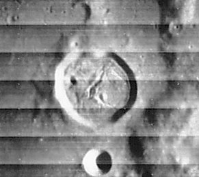
LOIV 065 H2
Note the system of rilles on Bohnenberger's floor.
Images
LPOD Photo Gallery Lunar Orbiter Images Apollo Images
Maps
(LAC zone 97A2) LAC map Geologic map
Description
Description: Elger
(IAU Directions) BOHNENBERGER.--A ring-plain about 22 miles in diameter, situated on the E. side of the Mare Nectaris, under the precipitous flanks of the Pyrenees, whose prominent shadows partially conceal it for many hours after sunrise. The circular border is comparatively low, and, except on the N., continuous. Here there is a gap, and on the E. of it an intrusive mass of rock. From its very peculiar shadow at sunrise, the wall on the W. appears to be very irregular. The club-shaped central mountain is of considerable size, but not conspicuous. S. of Bohnenberger stands the very attenuated ring, Bohnenberger A. It is of about the same diameter, has a large deep crater on its N. rim, and a smaller one, distinguished with difficulty, on its S.W. rim. On the N. of Bohnenberger there is a bright little ring-plain connected with the formation by a lofty ridge, under the W. flank of which Schmidt shows a crater-chain. An especially fine cleft originates on the W. side of this crater, which, following an undulating course over the Mare Nectaris, terminates at Rosse, N. of Fracastorius.
Description: Wikipedia
Additional Information
- Depth data from Kurt Fisher database
- Pike, 1976: 2.4 km
- Westfall, 2000: 2.4 km
- Viscardy, 1985: 1.06 km
- Cherrington, 1969: 2.34 km
- Central peak height
- Twin peaks on the south--0.4 km, two tall peaks--0.7km, one low hill--0.2 km - fatastronomer fatastronomer
- Satellite crater Bohnenberger G is on the ALPO list of bright ray craters and on the ALPO list of banded craters
Nomenclature
- Johann Gottlieb Friedrich von Bohnenberger (15 June 1765 – 19 April 1831) was a German astronomer. In 1798, he was appointed professor of mathematics and astronomy at the University of Tübingen. In 1817, he discovered the gyroscope effect.
- Bohnenberger Eta (elongated hill north of Bohnenberger and Bohnenberger F) (see page 87 in Tony Dethier's Maanmonografieen).
- Bohnenberger Lambda (small hill between Bohnenberger A and Santbech M) (south of Bohnenberger) (see Chart 86 in the Times Atlas of the Moon).
- Rimae Bohnenberger could be (?) a name for the system of rilles on the floor of Bohnenberger.
- Rimae Bohnenberger F (an unofficial name for the system of concentric rilles northwest of Bohnenberger F). http://bit.ly/2CLRmAI
LPOD Articles
Bibliography
This page has been edited 1 times. The last modification was made by - tychocrater tychocrater on Jun 13, 2009 3:24 pm - afx3u2