Difference between revisions of "Zach"
| Line 28: | Line 28: | ||
** Viscardy, 1985: 3.7 km | ** Viscardy, 1985: 3.7 km | ||
** Cherrington, 1969: 3.59 km | ** Cherrington, 1969: 3.59 km | ||
| − | * From the shadows in LO-IV-106H, '''Zach''' is up to 3760-4140 m deep <span class="membersnap">- | + | * From the shadows in LO-IV-106H, '''Zach''' is up to 3760-4140 m deep <span class="membersnap">- JimMosher</span> |
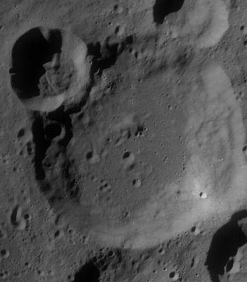
* High-albedo raycraterlet near the southeastern part of '''Zach''''s rim. Slightly northwest of this raycraterlet (and very near it) there are two boulders with tracks (a large boulder and a small one). <span class="membersnap">- DannyCaes <small>Jun 28, 2012</small></span> (Act-React Quick Map, LRO). | * High-albedo raycraterlet near the southeastern part of '''Zach''''s rim. Slightly northwest of this raycraterlet (and very near it) there are two boulders with tracks (a large boulder and a small one). <span class="membersnap">- DannyCaes <small>Jun 28, 2012</small></span> (Act-React Quick Map, LRO). | ||
<br /> | <br /> | ||
Latest revision as of 20:47, 16 April 2018
Contents
Zach
|
Lat: 60.99°S, Long: 5.35°E, Diam: 70.37 km, Depth: 4.46 km, Rükl: 73 | |
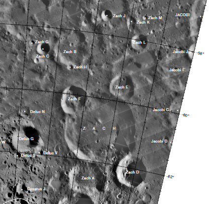
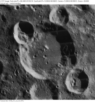
Right: LO-IV-106H Around the rim of Zach are the lettered craters (see lettered image also below) 24-km Zach E (at 1 o’clock), 32-km Zach D (at 4 o’clock), 36-km Zach A (at 6 o’clock), and 28-km Zach F (at 10 o’clock).
Images
LPOD Photo Gallery Lunar Orbiter Images
Maps
(LAC zone 126C3) LAC map Geologic map USGS Digital Atlas PDF
Description
Elger
(IAU Directions) ZACH.--A massive formation, 46 miles in diameter, on the S. of Lilius, with prominently terraced walls, rising on the W. to 13,000 feet above the interior. A small ring-plain, whose wall stands 6,000 feet above the floor, is associated with the N. border. Two other rings, on the S.E. and N.W. respectively, have craters on their ramparts and central hills.
Wikipedia
Additional Information
- IAU page: Zach
- Depth data from Kurt Fisher database
- Westfall, 2000: 4.46 km
- Viscardy, 1985: 3.7 km
- Cherrington, 1969: 3.59 km
- From the shadows in LO-IV-106H, Zach is up to 3760-4140 m deep - JimMosher
- High-albedo raycraterlet near the southeastern part of Zach's rim. Slightly northwest of this raycraterlet (and very near it) there are two boulders with tracks (a large boulder and a small one). - DannyCaes Jun 28, 2012 (Act-React Quick Map, LRO).
Nomenclature
- Baron Franz Xaver von Zach (June 4, 1754 – September 2, 1832) was a Hungarian astronomer.
- According to Whitaker (p. 220), this name was introduced by Mädler. Whitaker (p. 211) believes the same feature may have been previously known as Arzet to Riccioli.
- Near crater Zach is a crater which was once called Pollek (or perhaps... Pollock)(?). The name "Pollek" is mentioned in the additional volume to NAMED LUNAR FORMATIONS by Mary Blagg (see below; bibliography).
- The name "Pollock" (which was one of W.R. Birt's names) is mentioned in Ewen A. Whitaker's book (see below; bibliography).
- "Pollock" was printed on the moonmap of LPOD for February 11, 2004. It should have been a crater between Deluc and Zach.
- Between Clavius and Zach was W.R.Birt's Terra Photographica. This name was also printed on the moonmap of LPOD February 11, 2004.
- Research "Pollek", "Pollock", and "Terra Photographica": Danny Caes.
Lettered craters

Graphic LAC No. 126. Excerpt from the USGS Digital Atlas of the Moon.
LPOD Articles
Bibliography
- "Pollek" and "Terra Photographica": COLLATED LIST OF LUNAR FORMATIONS, NAMED AND LETTERED ON THE MAPS OF NEISON, SCHMIDT, AND MADLER, Mary Blagg.
- "Pollock" (and "Terra Photographica"): MAPPING AND NAMING THE MOON, Ewen A. Whitaker (page 221, Appendix J).
Named Features -- Prev: Catena Yuri -- Next: Zagut

