Difference between revisions of "Chadwick"
| (2 intermediate revisions by the same user not shown) | |||
| Line 2: | Line 2: | ||
=Chadwick= | =Chadwick= | ||
''(formerly '''[[De%20Roy|De Roy]] X''')''<div id="toc"> | ''(formerly '''[[De%20Roy|De Roy]] X''')''<div id="toc"> | ||
| − | + | <br /> | |
| − | |||
{| class="wiki_table" | {| class="wiki_table" | ||
| Lat: 52.85°S, Long: 101.31°W, Diam: 29.88 km, Depth: km, Rükl: ''(farside)''<br /> | | Lat: 52.85°S, Long: 101.31°W, Diam: 29.88 km, Depth: km, Rükl: ''(farside)''<br /> | ||
|} | |} | ||
| − | [http://www.mapaplanet.org/explorer-bin/explorer.cgi?map=Moon&layers=moon_clementine_multi&R=5&G=3&B=1&info=NO&advoption=YES&lines=300&samples=300&sizeSelector=resolution&Resolution=119&projection=MERC&grid=none&stretch=auto&north=-52.4&south=-53.8&west=-102.5&east=-99.9¢er=-101.2&defaultcenter=on¢er_lat=0 [[Image: | + | [http://www.mapaplanet.org/explorer-bin/explorer.cgi?map=Moon&layers=moon_clementine_multi&R=5&G=3&B=1&info=NO&advoption=YES&lines=300&samples=300&sizeSelector=resolution&Resolution=119&projection=MERC&grid=none&stretch=auto&north=-52.4&south=-53.8&west=-102.5&east=-99.9¢er=-101.2&defaultcenter=on¢er_lat=0 [[Image:Chadwick.t.jpg|external image jpg&height=300&width=300&bbox=-102.5,-53.8,-99.9,-52.4&resamp_method=nearest_neighbor]]]<br /> '''''Clementine UV-VIS Multispectral Mosaic''''': Mercator projection dynamically created by USGS lunar [http://www.mapaplanet.org/explorer/help/wmsUserDoc.html Web Map Service]. Click [http://planetarynames.wr.usgs.gov/jsp/AdvanceSearch2.jsp?body=Moon&ft=ALL&nlat=-52.4&slat=-53.8&wlon=-102.5&elon=-99.9&lonDirection=EAST&as=ANY&sort=AName&ShowType=Yes&ShowDiam=Yes&ShowLat=Yes&ShowLon=Yes&ShowAD=Yes here] for a USGS-generated list of all [[IAU|IAU]]-named features with centers in the current field.<br /> <br /> |
==Images== | ==Images== | ||
[http://www.lpod.org/coppermine/thumbnails.php?album=search&type=full&search=Chadwick LPOD Photo Gallery] [http://www.lpi.usra.edu/resources/lunar_orbiter/bin/srch_nam.shtml?Chadwick%7C0 Lunar Orbiter Images]<br /> <br /> | [http://www.lpod.org/coppermine/thumbnails.php?album=search&type=full&search=Chadwick LPOD Photo Gallery] [http://www.lpi.usra.edu/resources/lunar_orbiter/bin/srch_nam.shtml?Chadwick%7C0 Lunar Orbiter Images]<br /> <br /> | ||
| Line 33: | Line 32: | ||
[[Alphabetical%20Index|Named Features]] -- Prev: [[Rimae%20Chacornac|Rimae Chacornac]] -- Next: [[Chaffee|Chaffee]]<br /> | [[Alphabetical%20Index|Named Features]] -- Prev: [[Rimae%20Chacornac|Rimae Chacornac]] -- Next: [[Chaffee|Chaffee]]<br /> | ||
---- | ---- | ||
| − | + | </div> | |
Latest revision as of 18:38, 18 April 2018
Contents
Chadwick
(formerly De Roy X)
| Lat: 52.85°S, Long: 101.31°W, Diam: 29.88 km, Depth: km, Rükl: (farside) |

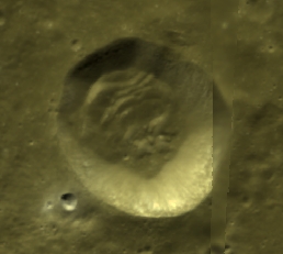
Clementine UV-VIS Multispectral Mosaic: Mercator projection dynamically created by USGS lunar Web Map Service. Click here for a USGS-generated list of all IAU-named features with centers in the current field.
Images
LPOD Photo Gallery Lunar Orbiter Images
Maps
(LAC zone 135A3) USGS Digital Atlas PDF
Description
Wikipedia
Additional Information
- IAU page: Chadwick
Nomenclature
- Named for Sir James Chadwick (1891-1974), a British physicist.
- Chadwick was added to a bank of names for future use on the Moon in IAU Transactions XVIB (1976).
- The name was approved for use in connection with the present crater in IAU Transactions XIXB (1985).
- Although the IAU Planetary Gazetteer lists this as a replacement name for De Roy X, the latter name would appear to have never been IAU approved since the farside lettered crater names introduced by Ewen Whitaker were not approved by the IAU until 2006, by which time this crater had been given its present name.
LPOD Articles
Bibliography
Named Features -- Prev: Rimae Chacornac -- Next: Chaffee