Difference between revisions of "Dorsa Mawson"
| Line 6: | Line 6: | ||
<div id="toc"> | <div id="toc"> | ||
=Table of Contents= | =Table of Contents= | ||
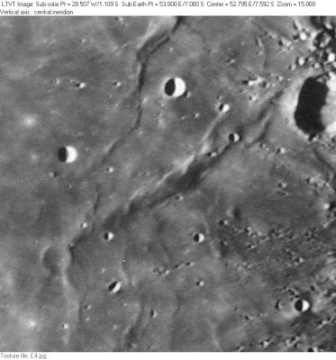
| − | <div style="margin-left: 1em">[#Dorsa Mawson Dorsa Mawson]</div><div style="margin-left: 2em">[#Dorsa Mawson-Images Images]</div><div style="margin-left: 2em">[#Dorsa Mawson-Maps Maps]</div><div style="margin-left: 2em">[#Dorsa Mawson-Description Description]</div><div style="margin-left: 2em">[#Dorsa Mawson-Description: Wikipedia Description: Wikipedia]</div><div style="margin-left: 2em">[#Dorsa Mawson-Additional Information Additional Information]</div><div style="margin-left: 2em">[#Dorsa Mawson-Nomenclature Nomenclature]</div><div style="margin-left: 2em">[#Dorsa Mawson-LPOD Articles LPOD Articles]</div><div style="margin-left: 2em">[#Dorsa Mawson-Bibliography Bibliography]</div></div>[http://www.lpod.org/coppermine/albums/userpics/Dorsa-Mawson_CLA-E4_LTVT.JPG [[Image:normal_Dorsa-Mawson_CLA-E4_LTVT.JPG|external image normal_Dorsa-Mawson_CLA-E4_LTVT.JPG]]]<br /> ''[http://lpod.org/coppermine/displayimage.php?pos=-2760 Consolidated Lunar Atlas; Plate E4]'' (remapped to aerial view) The large crater in the upper right is 43-km [ | + | <div style="margin-left: 1em">[#Dorsa Mawson Dorsa Mawson]</div><div style="margin-left: 2em">[#Dorsa Mawson-Images Images]</div><div style="margin-left: 2em">[#Dorsa Mawson-Maps Maps]</div><div style="margin-left: 2em">[#Dorsa Mawson-Description Description]</div><div style="margin-left: 2em">[#Dorsa Mawson-Description: Wikipedia Description: Wikipedia]</div><div style="margin-left: 2em">[#Dorsa Mawson-Additional Information Additional Information]</div><div style="margin-left: 2em">[#Dorsa Mawson-Nomenclature Nomenclature]</div><div style="margin-left: 2em">[#Dorsa Mawson-LPOD Articles LPOD Articles]</div><div style="margin-left: 2em">[#Dorsa Mawson-Bibliography Bibliography]</div></div>[http://www.lpod.org/coppermine/albums/userpics/Dorsa-Mawson_CLA-E4_LTVT.JPG [[Image:normal_Dorsa-Mawson_CLA-E4_LTVT.JPG|external image normal_Dorsa-Mawson_CLA-E4_LTVT.JPG]]]<br /> ''[http://lpod.org/coppermine/displayimage.php?pos=-2760 Consolidated Lunar Atlas; Plate E4]'' (remapped to aerial view) The large crater in the upper right is 43-km [[Bilharz|Bilharz]]. '''Dorsa Mawson''' extends diagonally from just west of [[Bilharz|Bilharz]] to the 22-km ghost crater '''[[Goclenius|Goclenius]] U''' in the lower left. The 8-km crater in the pockmarked area in the lower right is [[Al-Marrakushi|Al-Marrakushi]], Above '''Dorsa Mawson''' can be seen 11-km [[Ibn%20Battuta|Ibn Battuta]] (left) and 12-km [[Lindbergh|Lindbergh]] (center). The ridge extending northward from between [[Ibn%20Battuta|Ibn Battuta]] and [[Lindbergh|Lindbergh]] is the southern part of [[Dorsa%20Geikie|Dorsa Geikie]].<br /> <br /> |
==Images== | ==Images== | ||
[http://www.lpod.org/coppermine/thumbnails.php?album=search&type=full&search=Dorsa%20Mawson LPOD Photo Gallery] [http://www.lpi.usra.edu/resources/lunar_orbiter/bin/srch_nam.shtml?Dorsa%20Mawson%7C0 Lunar Orbiter Images]<br /> Because '''Dorsa Mawson''' is running south of '''Messier G''' ('''Lindbergh''') and '''Goclenius A''' ('''Ibn Battuta'''), all orbital Apollo photographs which show '''Dorsa Mawson''' (or parts of '''Dorsa Mawson''') should be online in the LPI's lists of [http://www.lpi.usra.edu/resources/apollo/search/feature/?feature=Messier+G&sort= Messier G] and [http://www.lpi.usra.edu/resources/apollo/search/feature/?feature=Goclenius+A&sort= Goclenius A]. <span class="membersnap">- [http://www.wikispaces.com/user/view/DannyCaes [[Image:DannyCaes-lg.jpg|16px|DannyCaes]]] [http://www.wikispaces.com/user/view/DannyCaes DannyCaes] <small>Aug 22, 2011</small></span><br /> <br /> | [http://www.lpod.org/coppermine/thumbnails.php?album=search&type=full&search=Dorsa%20Mawson LPOD Photo Gallery] [http://www.lpi.usra.edu/resources/lunar_orbiter/bin/srch_nam.shtml?Dorsa%20Mawson%7C0 Lunar Orbiter Images]<br /> Because '''Dorsa Mawson''' is running south of '''Messier G''' ('''Lindbergh''') and '''Goclenius A''' ('''Ibn Battuta'''), all orbital Apollo photographs which show '''Dorsa Mawson''' (or parts of '''Dorsa Mawson''') should be online in the LPI's lists of [http://www.lpi.usra.edu/resources/apollo/search/feature/?feature=Messier+G&sort= Messier G] and [http://www.lpi.usra.edu/resources/apollo/search/feature/?feature=Goclenius+A&sort= Goclenius A]. <span class="membersnap">- [http://www.wikispaces.com/user/view/DannyCaes [[Image:DannyCaes-lg.jpg|16px|DannyCaes]]] [http://www.wikispaces.com/user/view/DannyCaes DannyCaes] <small>Aug 22, 2011</small></span><br /> <br /> | ||
==Maps== | ==Maps== | ||
| − | ''([ | + | ''([[LAC%20zone|LAC zone]] 80A4)'' [http://www.lpi.usra.edu/resources/mapcatalog/LAC/lac80/ LAC map] [http://www.lpi.usra.edu/resources/mapcatalog/usgs/I739/ Geologic map] [http://www.lpi.usra.edu/resources/mapcatalog/LTO/lto80a4_1/ LTO map]<br /> <br /> |
==Description== | ==Description== | ||
<br /> | <br /> | ||
| Line 19: | Line 19: | ||
==Nomenclature== | ==Nomenclature== | ||
Douglas; English-Australian Antarctic explorer (1882-1958).<br /> | Douglas; English-Australian Antarctic explorer (1882-1958).<br /> | ||
| − | * This name was approved, along with one other unrelated [ | + | * This name was approved, along with one other unrelated [[dorsum|dorsa]], in 1979 ([[IAU%20Transactions%20XVIIB|IAU Transactions XVIIB]]). The citation mentions that the feature extends from "09.0S, 050.5E to 06.0S, 054.0E" giving an unusually clear indication for what the name is meant to represent. The name does not appear on [http://www.lpi.usra.edu/resources/mapcatalog/LTO/lto80a4_1/ LTO 80A4] (November, 1974), which depicts (somewhat vaguely) '''Dorsa Mawson''''s northeastern end. <span class="membersnap">- [http://www.wikispaces.com/user/view/JimMosher [[Image:JimMosher-lg.jpg|16px|JimMosher]]] [http://www.wikispaces.com/user/view/JimMosher JimMosher]</span> |
<br /> <br /> | <br /> <br /> | ||
==LPOD Articles== | ==LPOD Articles== | ||
Revision as of 14:46, 15 April 2018
Contents
Dorsa Mawson
| Lat: 7.0°S, Long: 53.0°E, Length: 132 km, Height: km, Rükl: 48 |
Table of Contents
[#Dorsa Mawson Dorsa Mawson]
[#Dorsa Mawson-Images Images]
[#Dorsa Mawson-Maps Maps]
[#Dorsa Mawson-Description Description]
[#Dorsa Mawson-Description: Wikipedia Description: Wikipedia]
[#Dorsa Mawson-Additional Information Additional Information]
[#Dorsa Mawson-Nomenclature Nomenclature]
[#Dorsa Mawson-LPOD Articles LPOD Articles]
[#Dorsa Mawson-Bibliography Bibliography]

Consolidated Lunar Atlas; Plate E4 (remapped to aerial view) The large crater in the upper right is 43-km Bilharz. Dorsa Mawson extends diagonally from just west of Bilharz to the 22-km ghost crater Goclenius U in the lower left. The 8-km crater in the pockmarked area in the lower right is Al-Marrakushi, Above Dorsa Mawson can be seen 11-km Ibn Battuta (left) and 12-km Lindbergh (center). The ridge extending northward from between Ibn Battuta and Lindbergh is the southern part of Dorsa Geikie.
Images
LPOD Photo Gallery Lunar Orbiter Images
Because Dorsa Mawson is running south of Messier G (Lindbergh) and Goclenius A (Ibn Battuta), all orbital Apollo photographs which show Dorsa Mawson (or parts of Dorsa Mawson) should be online in the LPI's lists of Messier G and Goclenius A. - DannyCaes DannyCaes Aug 22, 2011
Maps
(LAC zone 80A4) LAC map Geologic map LTO map
Description
Description: Wikipedia
Additional Information
Nomenclature
Douglas; English-Australian Antarctic explorer (1882-1958).
- This name was approved, along with one other unrelated dorsa, in 1979 (IAU Transactions XVIIB). The citation mentions that the feature extends from "09.0S, 050.5E to 06.0S, 054.0E" giving an unusually clear indication for what the name is meant to represent. The name does not appear on LTO 80A4 (November, 1974), which depicts (somewhat vaguely) Dorsa Mawson's northeastern end. - JimMosher JimMosher
LPOD Articles
Bibliography
This page has been edited 1 times. The last modification was made by - tychocrater tychocrater on Jun 13, 2009 3:24 pm - afx3u2