Difference between revisions of "Mare Parvum"
| Line 6: | Line 6: | ||
| Lat: 50°S, Long:94°W , Diam: 100 km, Depth: km, Rukl: (farside)<br /> | | Lat: 50°S, Long:94°W , Diam: 100 km, Depth: km, Rukl: (farside)<br /> | ||
|} | |} | ||
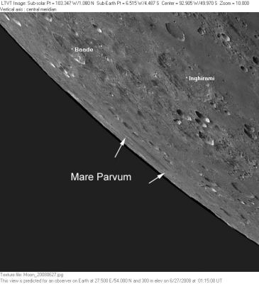
| − | [http://www.lpod.org/coppermine/albums/userpics/MareParvum_AstronMinsk_LTVT.JPG [[Image: | + | [http://www.lpod.org/coppermine/albums/userpics/MareParvum_AstronMinsk_LTVT.JPG [[Image:Normal_MareParvum_AstronMinsk_LTVT.JPG|external image normal_MareParvum_AstronMinsk_LTVT.JPG]]]<br /> ''[http://lpod.org/coppermine/displayimage.php?pos=-4154 AstronoMinsk imagers]'': This image of the Moon's southwest limb taken with a strong [[librations|libration]] shows which what was probably the feature intended by the discontinued IAU name '''Mare Parvum''', corresponding to the [http://lpod.org/coppermine/displayimage.php?pos=-2988 central mare] region of the [[Mendel-Rydberg%20Basin|Mendel-Rydberg Basin]].<br /> <br /> |
==Images== | ==Images== | ||
[http://www.lpod.org/coppermine/thumbnails.php?album=search&type=full&search=Mare%20Parvum LPOD Photo Gallery] [http://www.lpi.usra.edu/resources/lunar_orbiter/bin/srch_nam.shtml?Mendel%7C0 Lunar Orbiter Images]<br /> <br /> | [http://www.lpod.org/coppermine/thumbnails.php?album=search&type=full&search=Mare%20Parvum LPOD Photo Gallery] [http://www.lpi.usra.edu/resources/lunar_orbiter/bin/srch_nam.shtml?Mendel%7C0 Lunar Orbiter Images]<br /> <br /> | ||
Latest revision as of 02:03, 16 April 2018
Contents
Mare Parvum
(discontinued IAU name)| Lat: 50°S, Long:94°W , Diam: 100 km, Depth: km, Rukl: (farside) |
AstronoMinsk imagers: This image of the Moon's southwest limb taken with a strong libration shows which what was probably the feature intended by the discontinued IAU name Mare Parvum, corresponding to the central mare region of the Mendel-Rydberg Basin.
Images
LPOD Photo Gallery Lunar Orbiter Images
Maps
(LAC zone 135B1) USGS Digital Atlas PDF
Description
Additional Information
- The Mendel-Rydberg Basin has a mare area of 2,900 km^2 according to measurements by Jim Whitford-Stark.
Nomenclature
- "Parvum" is Latin for "small".
- The name Mare Parvum was introduced by Franz (Whitaker, p. 235). It most likely referred to the central mare of the Mendel-Rydberg Basin, but without seeing Franz' map it is difficult to be sure.
- Franz' name (attributed to his catalog numbers 1348-1350) was adopted into the original 1935 IAU nomenclature of Named Lunar Formations as entry 2257a (the "a" indicating it was note in the Collated List. It is described as "beyond" the southwest limb, with a latitude range of 49.1°S to 52.4°S (converted from the Xi-Eta values). This corresponds closely to the latitude range shown in the AstronoMinsk image from 2008 reproduced above. Mare Parvum is one of the very few features listed in Named Lunar Formations whose center is indicated as being beyond the mean limb.
- The name Mare Parvum was deleted by G. P. Kuiper in Table III of his 1960 Photographic Lunar Atlas, where it is listed as one of two "small patches of dark material not worthy of separate names" (the other being Mare Hiemis). Kuiper chose to retain other Franz names, such as Mare Aestatis, even though the dimensions are similar. His changes were approved by the IAU in 1961 (IAU Transactions XIB).
- Could have been called Palus Solitatis by the ALPO's amateur observers of the Luna Incognita project. Alas, this name was not approved by the IAU.
LPOD Articles
Bibliography
