Difference between revisions of "Curtius"
(Created page with "<div id="content_view" class="wiki" style="display: block"> =Curtius= {| class="wiki_table" | colspan="2" | Lat: 67.06°S, Long: 4.09°E, Diam: 96 km, Depth: 3.75 km, [/R%...") |
|||
| (3 intermediate revisions by the same user not shown) | |||
| Line 3: | Line 3: | ||
{| class="wiki_table" | {| class="wiki_table" | ||
| colspan="2" | | | colspan="2" | | ||
| − | Lat: 67.06°S, Long: 4.09°E, Diam: 96 km, Depth: 3.75 km, [ | + | Lat: 67.06°S, Long: 4.09°E, Diam: 96 km, Depth: 3.75 km, [[R%C3%BCkl%2073|Rükl: 73]]<br /> |
|- | |- | ||
| | | | ||
| − | [http://www.lpod.org/coppermine/displayimage.php?pid=5039&fullsize=1 [[Image: | + | [http://www.lpod.org/coppermine/displayimage.php?pid=5039&fullsize=1 [[Image:Normal_curtius.jpg|external image normal_curtius.jpg]]]<br /> |
| | | | ||
| − | [http://www.lpod.org/coppermine/albums/userpics/curtius2006-10-12a.jpg [[Image: | + | [http://www.lpod.org/coppermine/albums/userpics/curtius2006-10-12a.jpg [[Image:Normal_curtius2006-10-12a.jpg|external image normal_curtius2006-10-12a.jpg]]]<br /> |
|} | |} | ||
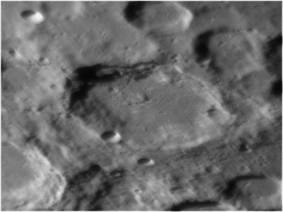
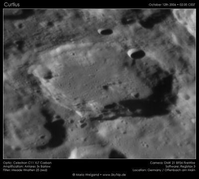
| − | '''Left:''' ''[http://lroc.sese.asu.edu/index.html LROC]'' WAC mosaic image (No.s [http://wms.lroc.asu.edu/lroc/view_lroc/LRO-L-LROC-2-EDR-V1.0/M119827656ME M119827656ME] and [http://wms.lroc.asu.edu/lroc/view_lroc/LRO-L-LROC-2-EDR-V1.0/M119834425ME M119834425ME]). Calibrated by [http://ltvt.wikispaces.com/Utility%20Programs#WAC_Viewer LROC_WAC_Previewer].<br /> '''Right''': ''[http://lpod.org/coppermine/displayimage.php?pos=-1004 Mario Weigand]'' This Earth-based view is oriented with sourth up. The 61-km crater in the lower left corner is '''Curtius D'''. In the extreme upper right corner, a small part of the sunlit inner wall of [ | + | '''Left:''' ''[http://lroc.sese.asu.edu/index.html LROC]'' WAC mosaic image (No.s [http://wms.lroc.asu.edu/lroc/view_lroc/LRO-L-LROC-2-EDR-V1.0/M119827656ME M119827656ME] and [http://wms.lroc.asu.edu/lroc/view_lroc/LRO-L-LROC-2-EDR-V1.0/M119834425ME M119834425ME]). Calibrated by [http://ltvt.wikispaces.com/Utility%20Programs#WAC_Viewer LROC_WAC_Previewer].<br /> '''Right''': ''[http://lpod.org/coppermine/displayimage.php?pos=-1004 Mario Weigand]'' This Earth-based view is oriented with sourth up. The 61-km crater in the lower left corner is '''Curtius D'''. In the extreme upper right corner, a small part of the sunlit inner wall of [[Moretus|Moretus]] can be seen. The 12-km diameter shadowed crater of '''Curtius''''s southwest rim (upper right in the Earth-based view) is '''Curtius A''', while the similarly-sized, but older, one on the east rim is '''Curtius E'''.<br /> <br /> <div id="toc"> |
| − | + | ||
| − | |||
==Images== | ==Images== | ||
[http://www.lpod.org/coppermine/thumbnails.php?album=search&type=full&search=Curtius LPOD Photo Gallery] [http://www.lpi.usra.edu/resources/lunar_orbiter/bin/srch_nam.shtml?Curtius%7C0 Lunar Orbiter Images]<br /> <br /> | [http://www.lpod.org/coppermine/thumbnails.php?album=search&type=full&search=Curtius LPOD Photo Gallery] [http://www.lpi.usra.edu/resources/lunar_orbiter/bin/srch_nam.shtml?Curtius%7C0 Lunar Orbiter Images]<br /> <br /> | ||
==Maps== | ==Maps== | ||
| − | ''([ | + | ''([[LAC%20zone|LAC zone]] 137B2)'' [http://planetarynames.wr.usgs.gov/images/Lunar/lac_137.pdf USGS Digital Atlas PDF] [http://www.mapaplanet.org/explorer-bin/explorer.cgi?map=Moon&layers=moon_clementine_multi&west=-9.22&south=-70.60&east=17.78&north=-60.84¢er_lat=0¢er=4.28&defaultcenter=on&grid=none&stretch=auto&projection=MERC&r=5&g=3&b=1&advoption=YES&info=NO&resolution=64&scale=0.47380&imageTopX=-204919.5326864719&imageTopY=-2497649.2868363857 Clementine UV-VIS Multispectral Mosaic]<br /> <br /> |
==Description== | ==Description== | ||
<br /> | <br /> | ||
===Elger=== | ===Elger=== | ||
| − | ''([ | + | ''([[IAU%20directions|IAU Directions]])'' CURTIUS.--A magnificent formation, about 50 miles in diameter, with one of the loftiest ramparts on the visible surface, rising at a mountain mass on the N.W. to more than 22,000 feet, an altitude which is only surpassed by peaks on the walls of [[Newton|Newton]] and [[Casatus|Casatus]]. There is a bright crater on the S.W. border and another on the E. The formation is too near the S. limb for satisfactory scrutiny. Between Curtius and [[Zach|Zach]] is a fine group of unnamed enclosures.<br /> <br /> |
===Wikipedia=== | ===Wikipedia=== | ||
[http://en.wikipedia.org/wiki/Curtius_(crater) Curtius]<br /> <br /> | [http://en.wikipedia.org/wiki/Curtius_(crater) Curtius]<br /> <br /> | ||
==Additional Information== | ==Additional Information== | ||
* IAU page: [http://planetarynames.wr.usgs.gov/Feature/1353 Curtius] | * IAU page: [http://planetarynames.wr.usgs.gov/Feature/1353 Curtius] | ||
| − | * Depth data from [ | + | * Depth data from [[Kurt%20Fisher%20Crater%20Depths|Kurt Fisher database]] |
** Westfall, 2000: 3.75 km | ** Westfall, 2000: 3.75 km | ||
** Cherrington, 1969: 3.96 km | ** Cherrington, 1969: 3.96 km | ||
| Line 31: | Line 30: | ||
==Nomenclature== | ==Nomenclature== | ||
| − | * Named for Albert Curtz (also known as [http://en.wikipedia.org/wiki/Albert_Curtz Curtius]) (1600-1671), a German astronomer. He expanded on the works of [ | + | * Named for Albert Curtz (also known as [http://en.wikipedia.org/wiki/Albert_Curtz Curtius]) (1600-1671), a German astronomer. He expanded on the works of [[Tycho|Tycho]] Brahe and used the pseudonym of Lucius Barrettus. |
| − | * This name has continued unchanged since its original use for this feature on [ | + | * This name has continued unchanged since its original use for this feature on [[Riccioli|Riccioli]]'s map (''[[Whitaker|Whitaker]]'', p. 211), except that it was there labeled '''Curtius Soc. I''', the '''Soc. I''' meaning "Society of Jesus" (see [[Nomenclature-Jesuits|Nomenclature-Jesuits]]). |
* '''Curtius B''', north of '''Curtius''' itself, was called '''Briggi''' by Van Langren (see page 195 in E.A.Whitaker's ''Mapping and Naming the Moon''). | * '''Curtius B''', north of '''Curtius''' itself, was called '''Briggi''' by Van Langren (see page 195 in E.A.Whitaker's ''Mapping and Naming the Moon''). | ||
<br /> | <br /> | ||
==Lettered craters== | ==Lettered craters== | ||
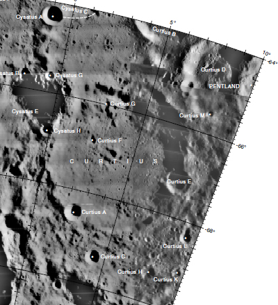
| − | [[Image: | + | [[Image:Curtius-letter.jpg|curtius-letter.jpg]]<br /> LAC [http://planetarynames.wr.usgs.gov/images/Lunar/lac_137_lo.pdf No. 137]. Excerpt from the ''[http://planetarynames.wr.usgs.gov/dAtlas.html USGS Digital Atlas of the Moon].''<br /> <br /> |
==LPOD Articles== | ==LPOD Articles== | ||
| − | [http://lpod.wikispaces.com/January%2017%2C%202011 Stray Chain]<br /> [http:// | + | [http://lpod.wikispaces.com/January%2017%2C%202011 Stray Chain]<br /> [http://www2.lpod.org/wiki/December_29,_2006 Pits and Plains.]<br /> <br /> |
==Bibliography== | ==Bibliography== | ||
| − | * Harold Hill. ''[ | + | * Harold Hill. ''[[A%20Portfolio%20of%20Lunar%20Drawings|A Portfolio of Lunar Drawings]]'', pages 186, 187. |
<br /> | <br /> | ||
---- | ---- | ||
| − | [ | + | [[Alphabetical%20Index|Named Features]] -- Prev: [[Curtis|Curtis]] -- Next: [[Cusanus|Cusanus]]<br /> |
---- | ---- | ||
| − | + | </div> | |
Latest revision as of 01:45, 16 April 2018
Contents
Curtius
|
Lat: 67.06°S, Long: 4.09°E, Diam: 96 km, Depth: 3.75 km, Rükl: 73 | |
Right: Mario Weigand This Earth-based view is oriented with sourth up. The 61-km crater in the lower left corner is Curtius D. In the extreme upper right corner, a small part of the sunlit inner wall of Moretus can be seen. The 12-km diameter shadowed crater of Curtius's southwest rim (upper right in the Earth-based view) is Curtius A, while the similarly-sized, but older, one on the east rim is Curtius E.
Images
LPOD Photo Gallery Lunar Orbiter Images
Maps
(LAC zone 137B2) USGS Digital Atlas PDF Clementine UV-VIS Multispectral Mosaic
Description
Elger
(IAU Directions) CURTIUS.--A magnificent formation, about 50 miles in diameter, with one of the loftiest ramparts on the visible surface, rising at a mountain mass on the N.W. to more than 22,000 feet, an altitude which is only surpassed by peaks on the walls of Newton and Casatus. There is a bright crater on the S.W. border and another on the E. The formation is too near the S. limb for satisfactory scrutiny. Between Curtius and Zach is a fine group of unnamed enclosures.
Wikipedia
Additional Information
- IAU page: Curtius
- Depth data from Kurt Fisher database
- Westfall, 2000: 3.75 km
- Cherrington, 1969: 3.96 km
Nomenclature
- Named for Albert Curtz (also known as Curtius) (1600-1671), a German astronomer. He expanded on the works of Tycho Brahe and used the pseudonym of Lucius Barrettus.
- This name has continued unchanged since its original use for this feature on Riccioli's map (Whitaker, p. 211), except that it was there labeled Curtius Soc. I, the Soc. I meaning "Society of Jesus" (see Nomenclature-Jesuits).
- Curtius B, north of Curtius itself, was called Briggi by Van Langren (see page 195 in E.A.Whitaker's Mapping and Naming the Moon).
Lettered craters

LAC No. 137. Excerpt from the USGS Digital Atlas of the Moon.
LPOD Articles
Bibliography
- Harold Hill. A Portfolio of Lunar Drawings, pages 186, 187.
Named Features -- Prev: Curtis -- Next: Cusanus

