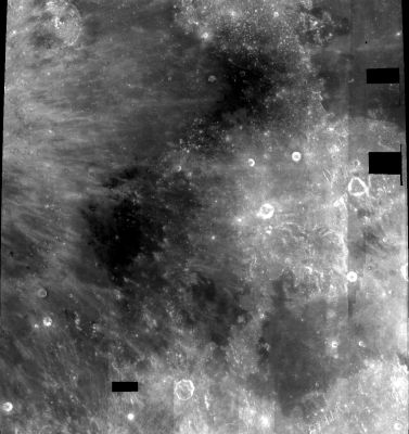
Sinus Medii
Contents
Sinus Medii (crash site of Surveyor 4 and landing site of Surveyor 6)
| Lat: 2.4°N, Long: 1.7°E, Diam: 335 km, Depth: km, Rükl: 33 |

Clementine Sinus Medii is the mare patch in the lower right. The crater touching the upper left corner is Eratosthenes. The large mare patch to its immediate lower right is Sinus Aestuum, with Mare Vaporum in the upper right. It is unclear if the smaller patches connecting Sinus Aestuum to Sinus Medii are regarded as part of one, the other, or neither.
Images
LPOD Photo Gallery Lunar Orbiter Images Apollo Images
- Close ups of Sinus Medii: Lunar Orbiter 3's frames 3086 to 3101. Research Danny Caes
Maps
(LAC zone 59C4) LAC map Geologic map AIC map
Description
Description: Wikipedia
Additional Information
- Mare area of 18,000 km^2 according to measurements by Jim Whitford-Stark.
- Frame 3084, an oblique image made by Lunar Orbiter 3, shows the part of Sinus Medii near the bowl-shaped craters Bruce and Blagg, and somewhere on LO3-084-h2 (a close-up of the area west-southwest of Bruce) should be the small impact-ejectablanket of Surveyor 4. Research Danny Caes
- See also: Lunar Heliotrope Project (Project PHAROS)
Possible swirl field west of Sinus Medii?
- The officially unnamed mare-like region west of Sinus Medii (between Sinus Medii and Schroter) might show a possible field of Reiner Gamma type swirls. It (this possible swirl field) could be investigated on the shadowless WAC mosaic of the LROC's Act-React Quick Map. See the short link to this (suspected) region: http://bit.ly/1Qwv2el (this possible swirl field was discovered, or perhaps re-discovered, by - DannyCaes Jan 26, 2016).
Nomenclature
- Sinus Medii was part of the original IAU nomenclature of Blagg and Müller (1935).
- The name is Latin for "Bay of the center".
- Section of the Face of the Woman in the Moon.
- Section of Ed Murray's C or Dark C.
- According to Whitaker the name has gone through many permutations: named Insula Medilunaria (Middlemoon Island) on a pre-telescopic sketch map by William Gilbert in ~1600 (p. 15), Sinus Medius (Middle Bay) by Van Langren (1645), Mare Adriaticum by Hevelius (1647), Sinus Aestuum by Riccioli (1651), Insula Sinus Medii (Island of the Middle Bay) by Cassini (1692), Sinus Medii by J. Bode (1780), Sinus Medius (again) by Gruithuisen (~1825), then Sinus Medii (again) by Beer and Mädler (~1837) and by Neison (1876).
LPOD Articles
Bibliography