Rima Krieger
Contents
Rima Krieger
|
Lat: 29.3°N, Long: 46.4°W, Length: 22 km, Depth: km, Rükl: 19 |
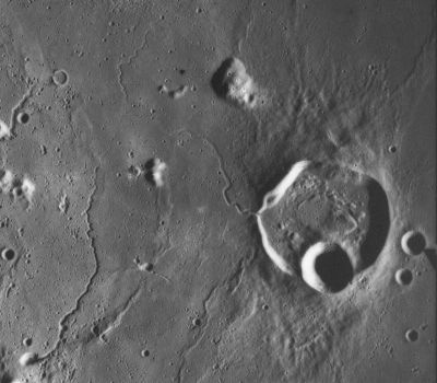
 AS-15-M2480 Rima Krieger snakes out of the west side of the polygonal crater Krieger. The crater on the south rim of Krieger is Van Biesbroeck, and the larger of the two to the east is Rocco. The rilles along the left side of the image are part of Rimae Aristarchus.
Images
LPOD Photo Gallery Lunar Orbiter Images Apollo Images
Maps
(LAC zone 39A1) LAC map Geologic map LM map LTO map Topophotomap
Description
This sinuous rille is thought to have been formed by lava flowing out from the floor of Krieger through the low point in the west rim. However, there is a possible faint extension of the rille onto the crater floor visible in the Apollo 15 panoramic photos used to construct Topophotomap 39A1S1, and the stereo mapping indicates that the apparent low point is actually about 20 m higher than the surface on either side. - JimMosher
Description: Wikipedia
Additional Information
- The coordinates given in the title line are measured from LTO 39A1. The position listed in the IAU Planetary Gazetteer is 29.0°N, 45.6°W, the same as Krieger. Since the rille is entirely to the west of Krieger they cannot be correct. However the length of 22 km appears accurate.
- Rima Krieger is a little under 800 m across, and its depth obviously diminishes to the east. Judging from the shadows in the Apollo 15 metric images used to construct LTO 39A1 (including the one reproduced above), apparently taken at around 12:48 UT on August 4, 1971, the deepest points, near the start about about 140 m deep, a value in reasonable agreement with the small section visible in Topophotomap 39A1S1. - JimMosher
Nomenclature
Named from nearby crater. (Krieger)
  Number 78 in Debra Hurwitz's Atlas and Catalog of Sinuous Rilles.
LPOD Articles
An invisible lava flow No Need to Draw Aperture
Bibliography