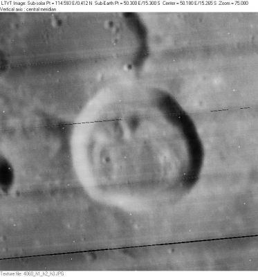
McClure
Contents
McClure
| Lat: 15.3°S, Long: 50.3°E, Diam: 23 km, Depth: 1.18 km, Rükl: 59 |
LO-IV-060H McClure is in the center. The 27-km crater partially visible in the upper left is McClure C. The shadow on the far left is from the east rim of 9-km McClure B.
Images
LPOD Photo Gallery Lunar Orbiter Images Apollo Images
WARNING: the name McClure is mentioned on many orbital frames of Apollo 12's three stereo-strips 56-B, 56-C, and 56-D. In fact, most of these frames don't show McClure at all! All the frames of these three stereo-strips show the same caption: DESCARTES - LALANDE - MCCLURE - THEOPHILUS (which seem to have been four of the most important "landmarks" on these stereo-strips).- DannyCaes Aug 15, 2010
- Apollo 8's oblique southward-looking Hasselblad frame AS08-13-2219 shows McClure near the frame's upper right corner.
Research: Danny Caes.
HiRes scan of Apollo 8 photograph: David Woods and Frank O'Brien (Apollo 8 Flight Journal).
Maps
(LAC zone 80D4) LAC map Geologic map
Description
Description: Elger
(IAU Directions) MACCLURE.--One of a curious group of formations situated in the Mare Fecunditatis some distance S.E. of Goclenius. It is a bright ring-plain, about 15 miles in diameter, with a narrow gap in the N.W. wall and a small central hill. A prominent ridge runs up to the N. border; and on the S.E. a rill-valley may be traced, extending S. to a bright deep little crater E. of Cook.
Description: Wikipedia
Additional Information
Depth data from Kurt Fisher database
- Westfall, 2000: 1.18 km
- Cherrington, 1969: 1.49 km
- Central peak height
- Sekiguchi, 1972: 0.7 km - fatastronomer
Nomenclature
Robert Le Mesurier; British explorer (1807-1873).
- According to Whitaker (p. 221), this name was introduced by Birt and Lee. Although Whitaker lists it as "McClure", the original spelling seems to have been "MacClure". - JimMosher
- McClure Delta (hill east of McClure, very near McClure P) (see Chart 75 in the Times Atlas of the Moon).
LPOD Articles
Bibliography
