Rupes Liebig
Contents
[hide]Rupes Liebig
|
Lat: 25.0°S, Long: 46.0°W, Length: 180 km, Height: km, Rükl 51 |

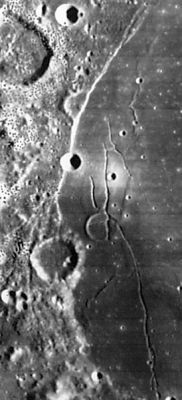
LOIV 149 H1 Rupes Liebig is the bright scarp above image center (passing through the relatively small circular crater (Liebig D). The scarp can be thought of as an extension of Rima Mersenius III, which extends out of it to the northeast.
Images
LPOD Photo Gallery Lunar Orbiter Images Apollo Images
- Oblique south-looking views of Rupes Liebig were captured during the mission of Apollo 16 in april 1972 (on color Hasselblad film). Several frames near the end of Magazine 120-V show the western "shoreline" of Mare Humorum with Rupes Liebig in it, photographed during local post-sunrise circumstances. Research Danny Caes
Maps
(LAC zone 93D1) LAC map Geologic map
Description
Description: Wikipedia
Additional Information
Nomenclature
- Named for the nearby crater (Liebig).
- This name was assigned in the System of Lunar Craters.
- Rupes Liebig was probably thought of as part of the Liebig Ir rille in the earlier IAU nomenclature.
- Nameless on Chart 79 in the Times Atlas of the Moon. Even the Rimae Doppelmayer south of Rupes Liebig is not named. - DannyCaes Apr 13, 2014
LPOD Articles
Cut by a Fault Humor Me Once More
Bibliography