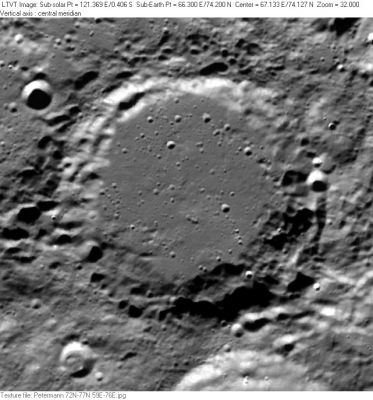
Petermann
Contents
[hide]Petermann
|
Lat: 74.37°N, Long: 67.74°E, Diam: 73.16 km, Depth: 3.0 km, Rükl 5, Nectarian |
Clementine The 8-km diameter circular crater in the upper right is Petermann S. The 11-km one in the lower left is Petermann B. The bright arch along the lower margin is the north rim of the neighboring crater Cusanus.
Images
LPOD Photo Gallery Lunar Orbiter Images
Maps
(LAC zone 5A3) USGS Digital Atlas PDF
Description
Wikipedia
Additional Information
- IAU page: Petermann
- Depth data from Kurt Fisher database
- Westfall, 2000: 3.33 km
- Cherrington, 1969: 3.68 km
- Measures on LRO QuickMap give depth range from about 1.8 to 3.5, ave about 43.0 km
- Remarkable flat mare-like region of Diameter 5 to 6 kilometers northeast of both Petermann A and Petermann Y. See: http://bit.ly/2Cf166g
Nomenclature
- Named for August Heinrich Petermann (1822-1878), a German cartographer and geographer especially noted for his contributions to knowledge about the then poorly known regions of Africa and the Arctic. Petermann contributed a nomenclature map of the Moon to Thomas Milner's 1850 book (republished in 1853). One of Petermann's students was Ernst Debes, who published a more extensive lunar guide.
- According to Whitaker (p. 224), this name was introduced by Schmidt.
LPOD Articles
Bibliography
- Anon. 1885. The House of Perthes, Of Gotha. The Publishers Weekly, Volume 28. p. 602.
- Milner, Thomas, and A. Petermann. 1850. A descriptive atlas of astronomy and of physical and political geography: with descriptive letter-press. London: Orr. (see also the reproduction of the lunar map in the International Planetary Cartography Database)
Named Features -- Prev: Rimae Petavius -- Next: Peters
