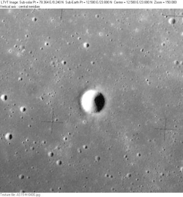
Hornsby
Contents
[hide]Hornsby
(formerly Aratus CB)
|
Lat: 23.78°N, Long: 12.5°E, Diam: 2.85 km, Depth: km, Rükl: 23 |
Images
LPOD Photo Gallery Lunar Orbiter Images Apollo Images
- Hornsby was also captured on Apollo 15's orbital ITEK-panoramic frames AS15-P-9346 and AS15-P-9351. In both frames, Hornsby is the largest one of the depicted craterlets.
- Research: Danny Caes
Maps
(LAC zone 42D1) LAC map Geologic map LM map LTO map
Description
Wikipedia
Additional Information
- IAU page: Hornsby
- The shadow in AS15-M-0406 indicates a depth of about 640 m. - Jim Mosher
Nomenclature
- Named for Thomas Hornsby (1733-1810), a British astronomer.
- This replacement name for a formerly lettered crater was introduced on LTO-42D1 (for which it served as the chart title). It appears in the cumulative list of approved names in IAU Transactions XVB (1973). Since it does not appear in any prior IAU Transactions, it was probably approved at the 1973 meeting. Biographical information was unofficially reported in Ashbrook, 1974. - Jim Mosher
LPOD Articles
Bibliography
Named Featues -- Prev: Horatio -- Next: Horrebow
