Difference between revisions of "Rima Byrgius"
| Line 7: | Line 7: | ||
|} | |} | ||
<div id="toc"> | <div id="toc"> | ||
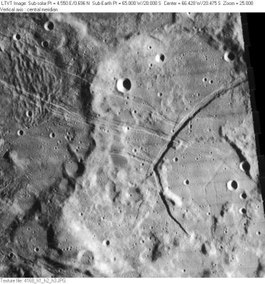
| − | [http://www.lpod.org/coppermine/displayimage.php?pid=3189&fullsize=1 [[Image: | + | [http://www.lpod.org/coppermine/displayimage.php?pid=3189&fullsize=1 [[Image:Normal_Rima_Byrgius_LO-IV-168H_LTVT.JPG|external image normal_Rima_Byrgius_LO-IV-168H_LTVT.JPG]]]<br /> ''[http://lpod.org/coppermine/displayimage.php?pos=-3189 LO-IV-168H]'' The discontinued name '''Rima Byrgius''' referred to the deeply shadowed arc-shaped [[rima|rille]] running vertically through the unnamed 130-km diameter enclosure to the right of center. The large crater partially visible on the left is [[Darwin|Darwin]] ([[Byrgius|Byrgius]] is just [http://lpod.org/coppermine/displayimage.php?pos=-4151 out of the field] to the lower right). The rilles that run horizontally across [[Darwin|Darwin]] and the unnamed enclosure are part of [[Rimae%20Darwin|Rimae Darwin]]. Just out of the field in the [http://the-moon.us/wiki/file/detail/Rukl_50_satellites_NE.jpg upper right] is the crater '''[[De%20Vico|De Vico]] A''' which the rille passes through. A wider angle view would show that '''Rima Byrgius''' is a natural and continuous extension of [[Rimae%20Sirsalis|Rimae Sirsalis]]; which, in the original [http://lpod.org/coppermine/displayimage.php?pos=-4152 IAU nomenclature] terminated at '''[[De%20Vico|De Vico]] A'''.<br /> <br /> |
==Images== | ==Images== | ||
[http://www.lpod.org/coppermine/thumbnails.php?album=search&type=full&search=Byrgius LPOD Photo Gallery] [http://www.lpi.usra.edu/resources/lunar_orbiter/bin/srch_nam.shtml?Byrgius%7C0 Lunar Orbiter Images]<br /> <br /> | [http://www.lpod.org/coppermine/thumbnails.php?album=search&type=full&search=Byrgius LPOD Photo Gallery] [http://www.lpi.usra.edu/resources/lunar_orbiter/bin/srch_nam.shtml?Byrgius%7C0 Lunar Orbiter Images]<br /> <br /> | ||
| Line 15: | Line 15: | ||
<br /> | <br /> | ||
==Description: Elger== | ==Description: Elger== | ||
| − | ''([[IAU% | + | ''([[IAU%20directions|IAU Directions]])'' [[Rimae%20Sirsalis|SIRSALIS]].-- ... One of the longest clefts on the visible surface runs immediately E. of this formation. Commencing at a minute crater on the N. of it, it grazes the foot of the E. <u>glacis</u>; then, passing a pair of small overlapping craters (resembling Sirsalis and its companion in miniature), it runs through a very rugged country to a ring-plain W. of [[De%20Vico|De Vico]] (De Vico <u>a</u>), which it traverses, and, still following a southerly course, extends towards [[Byrgius|Byrgius]], in the neighbourhood of which it is apparently lost at a ridge, though Schmidt and Gaudibert have traced it still farther in the same direction. <br /> <br /> |
==Additional Information== | ==Additional Information== | ||
<br /> | <br /> | ||
Latest revision as of 03:11, 16 April 2018
Contents
Rima Byrgius
(discontinued(?) IAU name; formerly Byrgius Cleft)
|
Lat: 20.5°S, Long: 65.0°W, Diam: 100 km, Depth: km, Rükl 50 |
LO-IV-168H The discontinued name Rima Byrgius referred to the deeply shadowed arc-shaped rille running vertically through the unnamed 130-km diameter enclosure to the right of center. The large crater partially visible on the left is Darwin (Byrgius is just out of the field to the lower right). The rilles that run horizontally across Darwin and the unnamed enclosure are part of Rimae Darwin. Just out of the field in the upper right is the crater De Vico A which the rille passes through. A wider angle view would show that Rima Byrgius is a natural and continuous extension of Rimae Sirsalis; which, in the original IAU nomenclature terminated at De Vico A.
Images
LPOD Photo Gallery Lunar Orbiter Images
Maps
(LAC zone 92A4) LAC map Geologic map
Description
Description: Elger
(IAU Directions) SIRSALIS.-- ... One of the longest clefts on the visible surface runs immediately E. of this formation. Commencing at a minute crater on the N. of it, it grazes the foot of the E. glacis; then, passing a pair of small overlapping craters (resembling Sirsalis and its companion in miniature), it runs through a very rugged country to a ring-plain W. of De Vico (De Vico a), which it traverses, and, still following a southerly course, extends towards Byrgius, in the neighbourhood of which it is apparently lost at a ridge, though Schmidt and Gaudibert have traced it still farther in the same direction.
Additional Information
Nomenclature
- Named after the nearby crater (Byrgius).
- Mary Blaggs's Collated List of 1913 noted three rilles near Byrgius: catalog entries 2055, 2056 and 2057.
- In the original IAU nomenclature of Blagg and Müller (1935), catalog entry 2057 became the Byrgius Cleft (a name attributed to Goodacre), while the other two rilles became Byrgius Ir and Byrgius IIr. Blagg and Müller were probably influenced by Neison, who had drawn catalog entry 2057 as an appoximately 330 km rille extending from De Vico A to Lagrage C (Elger suggests Schmidt and Gaudibert may also have imagined seeing it extending in that direction).
- Byrgius Cleft is listed as having been Latinized to Rima Byrgius in IAU Transactions XIIB (1964), which is supposed to be a summary of the changes introduced in the System of Lunar Craters. However, the name does not appear on the accompanying Quad Maps, and in fact the Byrgius Cleft is drawn there as an extension of Rimae Sirsalis, and the other two rilles seem to have assigned to a newly named Rimae Darwin. The depiction of the Byrgius Cleft as a continuous extension of the Sirsalis Cleft on the System of Lunar Craters maps is in accordance with Elger's description, and discounts Neison's claim of a further extension to the south (which seems to have been imaginary).
- Although there is no formal mention in the IAU Transactions of the name Rima Byrgius having been dropped, it is not listed in the IAU Planetary Gazetteer, where the position and dimensions of Rimae Sirsalis are large enough to encompass this region.
LPOD Articles
The Longest Rille A Rille Draped Across the Landscape A Long Graben
Bibliography
