Difference between revisions of "Debes"
| Line 6: | Line 6: | ||
|} | |} | ||
<div id="toc"> | <div id="toc"> | ||
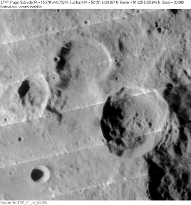
| − | + | [http://www.lpod.org/coppermine/albums/userpics/Debes-Tralles_LO-IV-191H_LTVT.JPG [[Image:normal_Debes-Tralles_LO-IV-191H_LTVT.JPG|external image normal_Debes-Tralles_LO-IV-191H_LTVT.JPG]]]<br /> ''[http://lpod.org/coppermine/displayimage.php?pos=-2714 LO-IV-191H]'' 30-km '''Debes''' is the uppermost crater in this grouping, with 43-km [[Tralles|Tralles]] to the right of center. Between them, below '''Debes''', is 33-km '''Debes A''', and to its left, the polygonal 19-km '''Debes B'''. The 11-km circular crater in the lower left is '''[[Tralles|Tralles]] B'''. The rugged inner wall of the west rim of 125-km [[Cleomedes|Cleomedes]] looms on the far right.<br /> <br /> | |
| − | |||
==Images== | ==Images== | ||
[http://www.lpod.org/coppermine/thumbnails.php?album=search&type=full&search=Debes LPOD Photo Gallery] [http://www.lpi.usra.edu/resources/lunar_orbiter/bin/srch_nam.shtml?Debes%7C0 Lunar Orbiter Images] [http://www.lpi.usra.edu/resources/apollo/search/feature/?feature=Debes Apollo Images]<br /> <br /> | [http://www.lpod.org/coppermine/thumbnails.php?album=search&type=full&search=Debes LPOD Photo Gallery] [http://www.lpi.usra.edu/resources/lunar_orbiter/bin/srch_nam.shtml?Debes%7C0 Lunar Orbiter Images] [http://www.lpi.usra.edu/resources/apollo/search/feature/?feature=Debes Apollo Images]<br /> <br /> | ||
| Line 43: | Line 42: | ||
[[Alphabetical%20Index|Named Featues]] -- Prev: [[De%20Vries|De Vries]] -- Next: [[Debus|Debus]]<br /> | [[Alphabetical%20Index|Named Featues]] -- Prev: [[De%20Vries|De Vries]] -- Next: [[Debus|Debus]]<br /> | ||
---- | ---- | ||
| − | + | </div> | |
Revision as of 17:19, 15 April 2018
Contents
Debes
|
Lat: 29.46°N, Long: 51.62°E, Diam: 31.92 km, Depth: 1.05 km, Rükl: 26 |
LO-IV-191H 30-km Debes is the uppermost crater in this grouping, with 43-km Tralles to the right of center. Between them, below Debes, is 33-km Debes A, and to its left, the polygonal 19-km Debes B. The 11-km circular crater in the lower left is Tralles B. The rugged inner wall of the west rim of 125-km Cleomedes looms on the far right.
Images
LPOD Photo Gallery Lunar Orbiter Images Apollo Images
Maps
(LAC zone 44A1) LAC map Geologic map
Description
Wikipedia
Additional Information
- IAU page: Debes
- Depth data from Kurt Fisher database
- Westfall, 2000: 1.05 km
Nomenclature
- Named for Ernst Debes (1840-1923), a German cartographer. "The Leipzig Geographical Institute of Wagner & Debes was the foremost German cartographic printer and publisher of cartographic work in the 19th- and early 20th century." Debes had been a student of Petermann. In 1922 he published a Moon atlas and "Handkarte." He is credited with adding one name later adopted by the IAU: the Jura Mountains.
- This feature is Catalog number 179 in Mary Blagg's Collated List where it is noted that it was called Tralles m by Julius Schmidt, but unnamed by the other authorities.
- In Named Lunar Formations the replacement name Debes is attributed to Karl Müller.
- Kuiper reports in Table III of his Photographic Lunar Atlas (approved by the IAU) that he has modified the IAU boundary of this feature: Now applies only to the northern component of the I.A.U. Debes.
- The designations Debes A and B for the southern components appear to have been introduced in the System of Lunar Craters.
LPOD Articles
Bibliography
- Debes, Ernst. 1922. Kleiner Mondatlas in 37 Einzeldatstellungen.
- The Linda Hall Library describes this as a 21-cm book with 12 double-page maps numbered 1-24 and two fold-out maps.
- Debes, Ernst. 1922. E. Debes' Handkarte des Mondes.
- Hinrichsen, Alex W. 2008. Baedeker’s Travel Guides: History of the publishing house (PDF, Debes in mentioned on page 41)
Named Featues -- Prev: De Vries -- Next: Debus
